File:Fusha e Tiranës 2008.jpg
出自Wikimedia Commons
跳至導覽
跳至搜尋

預覽大小:800 × 576 像素。 其他解析度:320 × 230 像素 | 640 × 461 像素 | 1,024 × 737 像素 | 1,280 × 922 像素 | 2,500 × 1,800 像素。
原始檔案 (2,500 × 1,800 像素,檔案大小:1.78 MB,MIME 類型:image/jpeg)
檔案資訊
結構化資料
說明
說明
添加單行說明來描述出檔案所代表的內容
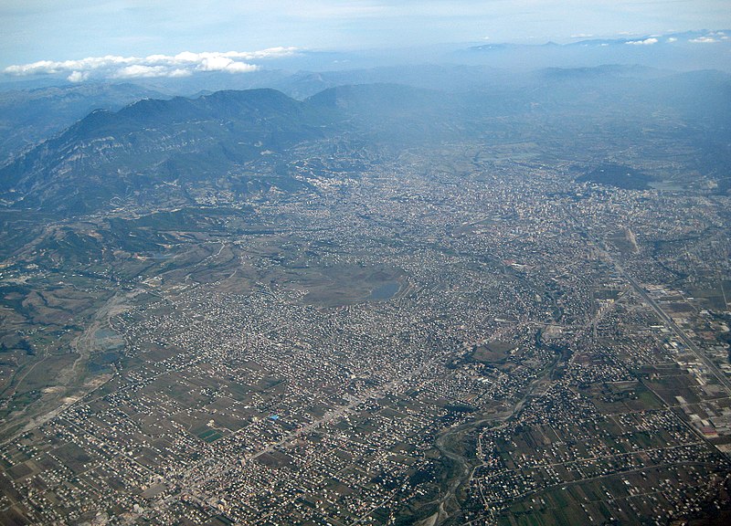
Aerial view of Tirana and surroundings
Luftaufnahme von Tirana und Umgebung
摘要
[編輯]| 描述Fusha e Tiranës 2008.jpg |
English: The Southern part of the Plain of Tirana (Albania). The mount Dajti at its Eastern end is in the upper left corner of the image. Tirana's high rise buildings and parks can be seen in the upper right corner. The motorway from Durrës in the West leading directly in Tirana's center is on the right hand side. From the lower left corner, the street from North Albania is heading to Tirana through the town of Kamza. Along this street, many new illegal settlements can be seen in the center of the picture. Between Kamza and Tirana, Tirana river makes its way to the Ocean (bottom center), as on the far left the River Zeza is to be recognized.
Deutsch: Der südliche Teil der Ebene von Tirana (Albanien) mit dem Berg Dajti links oben (Osten), den Hochhäusern und Grünflächen von Tirana rechts oben (Süden), der von Durrës im Westen herführenden Autobahn rechts, die als Hauptachse bis ins Stadtzentrum weitergeführt wird, dem Fluss Tirana unten, dem Fluss Zeza ganz links und der Strasse nach Norden unten links, entlang der rund um das Städtchen Kamza gewaltige Siedlungsflächen illegal überbaut wurden (Bildmitte) |
| 日期 | |
| 來源 | 自己的作品 |
| 作者 | Albinfo |
授權條款
[編輯]我,本作品的著作權持有者,決定用以下授權條款發佈本作品:
此檔案採用共享創意 姓名標示-相同方式分享 3.0 未在地化版本授權條款。
- 您可以自由:
- 分享 – 複製、發佈和傳播本作品
- 重新修改 – 創作演繹作品
- 惟需遵照下列條件:
- 姓名標示 – 您必須指名出正確的製作者,和提供授權條款的連結,以及表示是否有對內容上做出變更。您可以用任何合理的方式來行動,但不得以任何方式表明授權條款是對您許可或是由您所使用。
- 相同方式分享 – 如果您利用本素材進行再混合、轉換或創作,您必須基於如同原先的相同或兼容的條款,來分布您的貢獻成品。
| 註解 InfoField | 該圖片含有註解:在維基媒體共享資源上查看註解 |
128
325
869
272
2500
1800
Dajti
1969
544
422
122
2500
1800
Grand Park (Parku i madh) and Artificial Lake (Liqeni artificial)
528
981
753
344
2500
1800
Bathore
2188
1000
294
288
2500
1800
Motorway Tirana-Durrës
428
1547
513
213
2500
1800
Kamza
1775
922
184
456
2500
1800
Tirana River
1525
1069
306
153
2500
1800
Kodër Kamza
209
884
244
509
2500
1800
Zeza river
1619
506
253
53
2500
1800
Farka Lake
981
525
125
69
2500
1800
Linza
2225
753
259
97
2500
1800
Lana river
1719
613
359
144
2500
1800
center of Tirana
檔案歷史
點選日期/時間以檢視該時間的檔案版本。
| 日期/時間 | 縮圖 | 尺寸 | 用戶 | 備註 | |
|---|---|---|---|---|---|
| 目前 | 2008年11月12日 (三) 11:38 |  | 2,500 × 1,800(1.78 MB) | Albinfo(對話 | 貢獻) | {{Information |Description={{en|1=The Southern part of the Plain of Tirana (Albania). The mount Dajti at its Eastern end is in the upper left corner of the image. Tirana's high rise buildings and parks can be seen in the upper right corner. The motorway f |
無法覆蓋此檔案。
檔案用途
沒有使用此檔案的頁面。
全域檔案使用狀況
以下其他 wiki 使用了這個檔案:
- ba.wikipedia.org 的使用狀況
- be.wikipedia.org 的使用狀況
- bg.wikipedia.org 的使用狀況
- de.wikipedia.org 的使用狀況
- en.wikipedia.org 的使用狀況
- fa.wikipedia.org 的使用狀況
- lv.wikipedia.org 的使用狀況
- mdf.wikipedia.org 的使用狀況
- mk.wikipedia.org 的使用狀況
- mn.wikipedia.org 的使用狀況
- rm.wikipedia.org 的使用狀況
- ru.wikipedia.org 的使用狀況
- sco.wikipedia.org 的使用狀況
- sl.wikipedia.org 的使用狀況
- sq.wikipedia.org 的使用狀況
- sv.wikipedia.org 的使用狀況
- zh.wikipedia.org 的使用狀況
詮釋資料
此檔案中包含其他資訊,這些資訊可能是由數位相機或掃描器在建立或數位化過程中所新增的。若檔案自原始狀態已被修改,一些詳細資料可能無法完整反映出已修改的檔案。
| _error | 0 |
|---|