File:GOES-16 Geocolor Imagery of Hurricane Harvey Just Prior to Making Landfall (36816394625).jpg

元のファイル (1,338 × 894 ピクセル、ファイルサイズ: 178キロバイト、MIME タイプ: image/jpeg)
キャプション
キャプション
概要
[編集].jpg&action=edit§ion=1)
| 解説 |
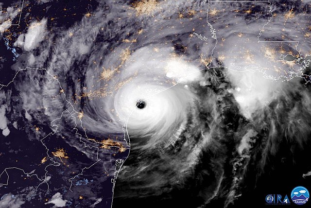
GOES-16 captured this geocolor imagery of Hurricane Harvey on the verge of making landfall on the Texas coast on August 25, 2017. The National Hurricane Center reported at 10:00 p.m. CDT that Harvey made landfall on the Texas coast. More info at goo.gl/b5gEAF Created by our partners at the Cooperative Institute for Research in the Atmosphere, the experimental geocolor enhancement displays geostationary satellite data in different ways depending on whether it is day or night. In nighttime imagery (shown here), liquid water clouds appear in shades of blue, ice clouds are grayish-white, water looks black, and land appears gray. The city lights are a static background created with VIIRS Day/Night Band imagery from the Suomi NPP satellite. Credit: CIRA Please note: GOES-16 data are currently experimental and under-going testing and hence should not be used operationally. |
| 日付 | |
| 原典 | GOES-16 Geocolor Imagery of Hurricane Harvey Just Prior to Making Landfall |
| 作者 | NOAA Satellites |
ライセンス
[編集].jpg&action=edit§ion=2)
|
|
| 当初、Flickrに投稿されたこの画像は、2017年9月10日に管理者又は画像査読者のWell-Informed Optimistによって査読され、その時点で、Flickr上で記載されたライセンスの下で利用可能であることが確認されました。 |
ファイルの履歴
過去の版のファイルを表示するには、その版の日時をクリックしてください。
| 日付と時刻 | サムネイル | 寸法 | 利用者 | コメント | |
|---|---|---|---|---|---|
| 現在の版 | 2017年9月3日 (日) 18:11 | | 1,338 × 894 (178キロバイト) | Victorgrigas (トーク | 投稿記録) | Transferred from Flickr via Flickr2Commons |
このファイルは上書きできません。
ファイルの使用状況
このファイルを使用しているページはありません。
グローバルなファイル使用状況
以下に挙げる他のウィキがこの画像を使っています:
- ja.wikipedia.org での使用状況
.jpg&oldid=854646677)