File:GOES-18 Monitors Wildfires Raging in Western Canada.png
পরিভ্রমণে চলুন
অনুসন্ধানে চলুন

এই প্রাকদর্শনের আকার: ৮০০ × ৪৫০ পিক্সেল। অন্যান্য আকারসমূহ: ৩২০ × ১৮০ পিক্সেল | ৬৪০ × ৩৬০ পিক্সেল | ১,০২৪ × ৫৭৬ পিক্সেল | ১,২৮০ × ৭২০ পিক্সেল | ১,৯২০ × ১,০৮০ পিক্সেল।
মূল ফাইল (১,৯২০ × ১,০৮০ পিক্সেল, ফাইলের আকার: ২.৬৭ মেগাবাইট, এমআইএমই ধরন: image/png)
ক্যাপশনসমূহ
ক্যাপশন
এই ফাইল কি প্রতিনিধিত্ব করছে তার এক লাইন ব্যাখ্যা যোগ করুন
সারাংশ
[সম্পাদনা]
| বিবরণ |
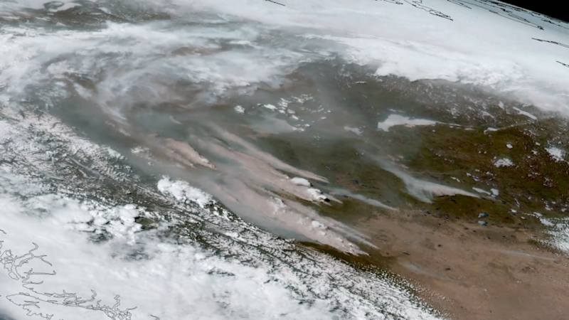
English: GOES-18 (GOES West) GeoColor imagery showing the smoke from wildfires raging in western Canada.
In early May 2023, fires ignited across western Canada due to unusually hot and dry weather. NOAA satellites watched as the fires raged, burning about one million acres. GOES-18 monitored the spread of the fires and smoke across the region. The ABI instrument on GOES-18 observed the formation of pyrocumulonimbus clouds from intense fires in Alberta. Learn more: www.nesdis.noaa.gov/news/wildfires-rage-western-canada |
| তারিখ | |
| উৎস | https://www.flickr.com/photos/noaasatellites/52888871147/ |
| লেখক | NOAA Satellites |
লাইসেন্স প্রদান
[সম্পাদনা]
| এই চিত্রটি প্রথম ফ্লিকারে NOAASatellites কর্তৃক https://flickr.com/photos/125201706@N06/52888871147 -এ প্রকাশ করা হয়েছিল। FlickreviewR 2 রোবট কর্তৃক ৬ জুন ২০২৩ তারিখে এটি পর্যালোচনা করা হয় এবং Public Domain Mark শর্তাবলীর অধীনে লাইসেন্স নিশ্চিত করা হয়। |
This image is in the public domain because it contains materials that originally came from the U.S. National Oceanic and Atmospheric Administration, taken or made as part of an employee's official duties.
|
ফাইলের ইতিহাস
যেকোনো তারিখ/সময়ে ক্লিক করে দেখুন ফাইলটি তখন কী অবস্থায় ছিল।
| তারিখ/সময় | সংক্ষেপচিত্র | মাত্রা | ব্যবহারকারী | মন্তব্য | |
|---|---|---|---|---|---|
| বর্তমান | ০৮:২৬, ৬ জুন ২০২৩ | | ১,৯২০ × ১,০৮০ (২.৬৭ মেগাবাইট) | Fumikas Sagisavas (আলোচনা | অবদান) | Uploaded a work by NOAA Satellites from https://www.flickr.com/photos/noaasatellites/52888871147/ with UploadWizard |
আপনি এই ফাইলটি প্রতিস্থাপন করতে পারবেন না।
ফাইলের ব্যবহার
এই ফাইল ব্যবহার করে এমন কোনো পাতা নেই।
ফাইলের বৈশ্বিক ব্যবহার
নিচের অন্যান্য উইকিগুলো এই ফাইলটি ব্যবহার করে:
- bn.wikipedia.org-এ ব্যবহার
- de.wikipedia.org-এ ব্যবহার
- es.wikipedia.org-এ ব্যবহার
- fa.wikipedia.org-এ ব্যবহার
- id.wikipedia.org-এ ব্যবহার
- ur.wikipedia.org-এ ব্যবহার