File:GOF Photo.jpg
Spring til navigation
Spring til søgning

Størrelse af denne forhåndsvisning: 800 × 600 pixels. Andre opløsninger: 320 × 240 pixels | 640 × 480 pixels | 1.024 × 768 pixels | 1.200 × 900 pixels.
Oprindelig fil (1.200 × 900 billedpunkter, filstørrelse: 189 KB, MIME-type: image/jpeg)
Captions
Captions
Tilføj en kort forklaring på en enkelt linje om hvad filen viser
| Beskrivelse |
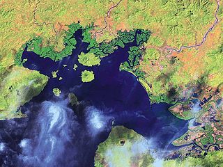
English: Satellite Image of the Gulf of Fonseca
Español: Imagen de satélite del Golfo de Fonseca |
| Dato | |
| Kilde | National Oceanic and Atmospheric Administration |
| Forfatter | NOAA |
| Andre versioner |

Licensering
[redigér]
This image is in the public domain because it contains materials that originally came from the U.S. National Oceanic and Atmospheric Administration, taken or made as part of an employee's official duties.
|
Oprindelig oplægningslog
[redigér]
The original description page was here. All following user names refer to en.wikipedia.
- 2008-01-31 19:23 Mwilburn38 1200×900× (193791 bytes) {{Information |Description=Satellite Image of the Gulf of Fonseca |Source=National Oceanic and Atmospheric Administration |Date=2001 |Location=http://www.noaa.gov |Author=NOAA |Permission= |other_versions= }}
Filhistorik
Klik på en dato/tid for at se filen som den så ud på det tidspunkt.
| Dato/tid | Miniaturebillede | Dimensioner | Bruger | Kommentar | |
|---|---|---|---|---|---|
| nuværende | 5. apr. 2010, 14:38 | | 1.200 × 900 (189 KB) | Urdangaray (diskussion | bidrag) | {{Information |Description={{en|Satellite Image of the Gulf of Fonseca}} |Source=Transferred from [http://en.wikipedia.org en.wikipedia]<br/> (Original text : ''National Oceanic and Atmospheric Administration'') |Date=2001<br/> ({{Date|2008|01|31}} (origi |
Du kan ikke overskrive denne fil.
Filanvendelse
De følgende 2 sider bruger denne fil:
Global filanvendelse
Følgende andre wikier anvender denne fil:
- Anvendelser på ar.wikipedia.org
- Anvendelser på ast.wikipedia.org
- Anvendelser på bg.wikipedia.org
- Anvendelser på ca.wikipedia.org
- Anvendelser på ceb.wikipedia.org
- Anvendelser på cs.wikipedia.org
- Anvendelser på de.wikipedia.org
- Anvendelser på en.wikipedia.org
- Anvendelser på eo.wikipedia.org
- Anvendelser på es.wikipedia.org
- Anvendelser på eu.wikipedia.org
- Anvendelser på fa.wikipedia.org
- Anvendelser på fi.wikipedia.org
- Anvendelser på fr.wikipedia.org
- Anvendelser på gl.wikipedia.org
- Anvendelser på hr.wikipedia.org
- Anvendelser på hy.wikipedia.org
- Anvendelser på id.wikipedia.org
- Anvendelser på ilo.wikipedia.org
- Anvendelser på it.wikipedia.org
- Anvendelser på ja.wikipedia.org
- Anvendelser på kk.wikipedia.org
- Anvendelser på ko.wikipedia.org
- Anvendelser på mk.wikipedia.org
- Anvendelser på mr.wikipedia.org
- Anvendelser på mt.wikipedia.org
- Anvendelser på nl.wikipedia.org
- Anvendelser på nn.wikipedia.org
- Anvendelser på no.wikipedia.org
- Anvendelser på pa.wikipedia.org
- Anvendelser på pl.wikipedia.org
- Anvendelser på pnb.wikipedia.org
- Anvendelser på pt.wikipedia.org
Vis flere globale anvendelser af denne fil.