File:Gabrielle 09 sept 2007 1800Z.jpg

原始檔案 (5,080 × 7,200 像素,檔案大小:6.11 MB,MIME 類型:image/jpeg)
說明
說明
摘要[編輯]
| 描述Gabrielle 09 sept 2007 1800Z.jpg |
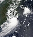
Tropical Storm Gabrielle briefly crossed land, touching North Carolina’s Outer Banks on September 9, 2007. The center of the storm came near Cape Lookout National Seashore, and after passing over Pamlico Sound briefly, headed back out to sea just twelve hours later near Kill Devil Hills. The storm system was not at all dramatic, with peak winds around 70 kilometers per hour (45 miles per hour) as it passed over the Outer Banks, according to the Associated Press. As of the afternoon of September 10, the storm was expected to stay out to sea and weaken as it crossed cooler water. In North Carolina, there were no reports of emergency calls or serious damage, and mostly the storm system was credited with light rains and some inconvenience. The MODIS on NASA's Aqua satellite acquired this photo-like image at 2:00 p.m. local time (18:00 UTC) on September 9, 2007. The loose structure of the storm system, with only a hint of spiral structure, and the patchy clouds show that Gabrielle was not a particularly dangerous or powerful storm. However, the storm did have a discernible if not dramatic eye. Here, the eye appears over Pamlico Sound, behind the barrier of islands that forms the Outer Banks of North Carolina. |
||||||
| 日期 | |||||||
| 來源 | http://modis.gsfc.nasa.gov/gallery/individual.php?db_date=2007-09-12 | ||||||
| 作者 | Jeff Schmaltz, MODIS Land Rapid Response Team, NASA GSFC | ||||||
| 授權許可 (重用此檔案) |
|
檔案歷史
點選日期/時間以檢視該時間的檔案版本。
| 日期/時間 | 縮圖 | 尺寸 | 使用者 | 備註 | |
|---|---|---|---|---|---|
| 目前 | 2018年12月3日 (一) 22:01 |  | 5,080 × 7,200(6.11 MB) | CooperScience(留言 | 貢獻) | Higher quality, corrected color |
| 2007年9月12日 (三) 13:41 |  | 3,556 × 4,000(2.82 MB) | Good kitty(留言 | 貢獻) | == Summary == {{Information |Description=Tropical Storm Gabrielle briefly crossed land, touching North Carolina’s Outer Banks on September 9, 2007. The center of the storm came near Cape Lookout National Seashore, and after passing over Pamlico Sound br |
無法覆蓋此檔案。
檔案用途
下列2個頁面有用到此檔案:
全域檔案使用狀況
以下其他 wiki 使用了這個檔案:
- de.wikipedia.org 的使用狀況
- en.wikipedia.org 的使用狀況
- es.wikipedia.org 的使用狀況
- ko.wikipedia.org 的使用狀況
- nl.wikipedia.org 的使用狀況
- pt.wikipedia.org 的使用狀況
- simple.wikipedia.org 的使用狀況
- sv.wikipedia.org 的使用狀況
- zh.wikipedia.org 的使用狀況
詮釋資料
此檔案中包含其他資訊,這些資訊可能是由數位相機或掃描器在建立或數位化過程中所新增的。若檔案自原始狀態已被修改,一些詳細資料可能無法完整反映出已修改的檔案。
| JPEG 檔案備註 | CREATOR: gd-jpeg v1.0 (using IJG JPEG v62), quality = 80 |
|---|

