File:Ganganagar district map.jpg
跳转到导航
跳转到搜索

本预览的尺寸:737 × 600像素。 其他分辨率:295 × 240像素 | 590 × 480像素 | 944 × 768像素 | 1,024 × 833像素。
原始文件 (1,024 × 833像素,文件大小:175 KB,MIME类型:image/jpeg)
说明
说明
添加一行文字以描述该文件所表现的内容
摘要
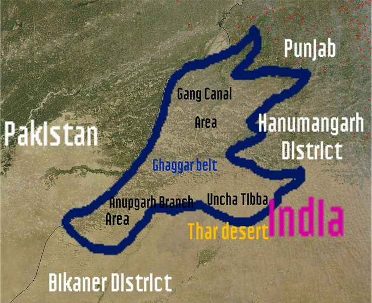
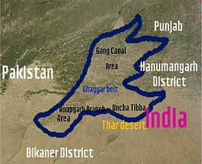
[编辑]| 描述 | I (wikiuser:Shemaroo aka Shivender Singh)have uploaded this photo and created by Nasa and this photo is in Public domain.In this photo you can see satellite image of Ganganagar district.Email:Sivendersingh@gmail.comShemaroo (talk) 07:25, 27 February 2012 (UTC) |
| 来源 | |
| 作者 | See below |


许可协议
[编辑]
| 本文件完全由NASA创作,在美国属于公有领域。根据NASA的版权方针,NASA的材料除非另有声明否则不受版权保护。(参见Template:PD-USGov/zh、NASA版权方针页面或JPL图片使用方针。) | ||
 |
警告:
|
原始上传日志
[编辑]
The original description page was here. All following user names refer to en.wikipedia.
| 日期/时间 | 大小 | 用户 | 备注 |
|---|---|---|---|
| 2012-02-27 07:25:31 | 1024× 833× | Shemaroo | I (wikiuser:Shemaroo aka Shivender Singh)have uploaded this photo and created by Nasa and this photo is in Public domain.In this photo you can see map of Ganganagar district.~~~~ |
文件历史
点击某个日期/时间查看对应时刻的文件。
| 日期/时间 | 缩略图 | 大小 | 用户 | 备注 | |
|---|---|---|---|---|---|
| 当前 | 2016年11月5日 (六) 20:23 | | 1,024 × 833(175 KB) | Zppix(留言 | 贡献) | Transferred from en.wikipedia (MTC!) |
您不可以覆盖此文件。
文件用途
没有页面使用本文件。
全域文件用途
以下其他wiki使用此文件:
- en.wikipedia.org上的用途
- zh.wikipedia.org上的用途