File:General map of the Spanish Civil War (1936–39).svg
跳至導覽
跳至搜尋

此 SVG 檔案的 PNG 預覽的大小:694 × 599 像素。 其他解析度:278 × 240 像素 | 556 × 480 像素 | 889 × 768 像素 | 1,186 × 1,024 像素 | 2,372 × 2,048 像素 | 938 × 810 像素。
原始檔案 (SVG 檔案,表面大小:938 × 810 像素,檔案大小:1.77 MB)
說明
說明
添加單行說明來描述出檔案所代表的內容
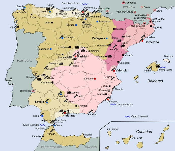
General map of the Spanish Civil War (1936–1939)
摘要
[編輯].svg&action=edit§ion=1)
| 描述 |
Español: Mapa general de la Guerra Civil Española (1936-1939).
Zona sublevada inicial - julio 1936
Avance sublevado hasta septiembre de 1936
Avance sublevado hasta octubre de 1937
Avance sublevado hasta noviembre de 1938
Avance sublevado hasta febrero de 1939
Última zona bajo control republicano
English: General map of the Spanish Civil War (1936-1939).
Initial Rebel zone - July 1936
Rebel advance until September 1936
Rebel advance until October 1937
Rebel advance until November 1938
Rebel advance until February 1939
Last area under Republican control
中文:1936年至1939年西班牙内战图示
1936年7月国民军初始控制范围
1936年9月国民军控制范围
1937年10月国民军控制范围
1938年11月国民军控制范围
1939年2月国民军控制范围
共和军最后控制范围
|
| 日期 | |
| 來源 | 自己的作品==> CORRECTED ALIGNMENT KEY COLORS-MAP COLORS from this source: File:Guerra Civil Española.svg. |
| 作者 | FDRMRZUSA |
| 授權許可 (重用此檔案) |
我,本作品的著作權持有者,決定用以下授權條款發佈本作品: 此檔案採用共享創意 姓名標示-相同方式分享 4.0 國際授權條款。
|
檔案歷史
點選日期/時間以檢視該時間的檔案版本。
| 日期/時間 | 縮圖 | 尺寸 | 用戶 | 備註 | |
|---|---|---|---|---|---|
| 目前 | 2021年10月14日 (四) 16:25 | | 938 × 810(1.77 MB) | Lojwe(對話 | 貢獻) | Elimino marco |
| 2018年12月20日 (四) 18:09 |  | 938 × 810(1.77 MB) | FDRMRZUSA(對話 | 貢獻) | Adjustments. | |
| 2018年12月20日 (四) 17:47 |  | 1,000 × 869(1.77 MB) | FDRMRZUSA(對話 | 貢獻) | User created page with UploadWizard |
無法覆蓋此檔案。
檔案用途
下列3個頁面有用到此檔案:
全域檔案使用狀況
以下其他 wiki 使用了這個檔案:
- ar.wikipedia.org 的使用狀況
- bg.wikipedia.org 的使用狀況
- de.wikipedia.org 的使用狀況
- en.wikipedia.org 的使用狀況
- es.wikipedia.org 的使用狀況
- fr.wikipedia.org 的使用狀況
- it.wikipedia.org 的使用狀況
- ja.wikipedia.org 的使用狀況
- ko.wikipedia.org 的使用狀況
- pnb.wikipedia.org 的使用狀況
- uk.wikipedia.org 的使用狀況
- ur.wikipedia.org 的使用狀況
- zh.wikipedia.org 的使用狀況
.svg&oldid=891445813)