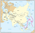
File:Geographic Boundaries of the First and Second Island Chains.png
出自Wikimedia Commons
跳至導覽
跳至搜尋

預覽大小:621 × 600 像素。 其他解析度:248 × 240 像素 | 497 × 480 像素 | 795 × 768 像素 | 1,060 × 1,024 像素 | 1,387 × 1,340 像素。
原始檔案 (1,387 × 1,340 像素,檔案大小:51 KB,MIME 類型:image/png)
檔案資訊
結構化資料
說明
說明
添加單行說明來描述出檔案所代表的內容
A map showing the first and second island chains along with related countries
| 描述Geographic Boundaries of the First and Second Island Chains.png | Figure 2. Geographic Boundaries of the First and Second Island Chains | ||||
| 日期 | 05/23/06 | ||||
| 來源 | Image:China Report 2006.pdf | ||||
| 作者 | DoD | ||||
| 授權許可 (重用此檔案) |
|
檔案歷史
點選日期/時間以檢視該時間的檔案版本。
| 日期/時間 | 縮圖 | 尺寸 | 使用者 | 備註 | |
|---|---|---|---|---|---|
| 目前 | 2018年3月8日 (四) 00:24 |  | 1,387 × 1,340(51 KB) | Ras67(留言 | 貢獻) | new extracted and cropped from the PDF |
| 2016年11月7日 (一) 11:32 |  | 1,434 × 1,378(104 KB) | Ricky22p(留言 | 貢獻) | Better quality version extracted from the same PDF file using GNOME Document Viewer. | |
| 2006年5月26日 (五) 08:29 |  | 1,431 × 1,121(89 KB) | Shizhao(留言 | 貢獻) | {{Information |Description=Figure 2. Geographic Boundaries of the First and Second Island Chains |Source=Image:China Report 2006.pdf |Date=05/23/06 |Author=DoD |Permission={{PD-USGov-Military}} |other_versions= }} [[Category:Chinas' Military Power Re |
無法覆蓋此檔案。
檔案用途
下列頁面有用到此檔案:
全域檔案使用狀況
以下其他 wiki 使用了這個檔案:
- ar.wikipedia.org 的使用狀況
- de.wikipedia.org 的使用狀況
- en.wikipedia.org 的使用狀況
- fa.wikipedia.org 的使用狀況
- fr.wikipedia.org 的使用狀況
- id.wikipedia.org 的使用狀況
- it.wikipedia.org 的使用狀況
- ja.wikipedia.org 的使用狀況
- ko.wikipedia.org 的使用狀況
- no.wikipedia.org 的使用狀況
- pt.wikipedia.org 的使用狀況
- uk.wikipedia.org 的使用狀況
- vi.wikipedia.org 的使用狀況
- www.wikidata.org 的使用狀況
- zh.wikipedia.org 的使用狀況
詮釋資料
此檔案中包含其他資訊,這些資訊可能是由數位相機或掃描器在建立或數位化過程中所新增的。若檔案自原始狀態已被修改,一些詳細資料可能無法完整反映出已修改的檔案。
| 水平解析度 | 107.92 dpc |
|---|---|
| 垂直解析度 | 107.92 dpc |
