File:Geologic map of Seymour Island, Antarctica.png
Aller à la navigation
Aller à la recherche

Taille de cet aperçu : 557 × 599 pixels. Autres résolutions : 223 × 240 pixels | 446 × 480 pixels | 714 × 768 pixels | 951 × 1 024 pixels | 1 350 × 1 453 pixels.
Fichier d’origine (1 350 × 1 453 pixels, taille du fichier : 268 kio, type MIME : image/png)
Légendes
Légendes
Ajoutez en une ligne la description de ce que représente ce fichier
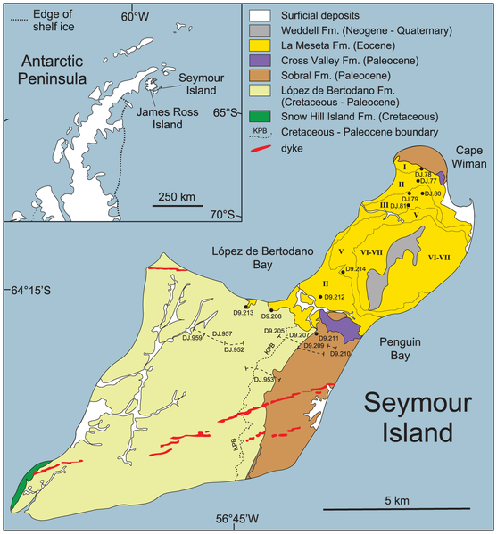
Geologic map of Seymour Island, Antarctica
Description
[modifier]
| Description |
English: Geologic map of Seymour Island, Antarctica with:
|
| Date | |
| Source | (2014). "The Early Origin of the Antarctic Marine Fauna and Its Evolutionary Implications". PLOS ONE 7. DOI:10.1371/journal.pone.0114743. |
| Auteur | Crame et al., 2014, PLoS ONE |
Conditions d’utilisation
[modifier]
Ce fichier est sous la licence Creative Commons Attribution – Partage dans les Mêmes Conditions 4.0 International.
- Vous êtes libre :
- de partager – de copier, distribuer et transmettre cette œuvre
- d’adapter – de modifier cette œuvre
- Sous les conditions suivantes :
- paternité – Vous devez donner les informations appropriées concernant l'auteur, fournir un lien vers la licence et indiquer si des modifications ont été faites. Vous pouvez faire cela par tout moyen raisonnable, mais en aucune façon suggérant que l’auteur vous soutient ou approuve l’utilisation que vous en faites.
- partage à l’identique – Si vous modifiez, transformez, ou vous basez sur cette œuvre, vous devez distribuer votre contribution sous la même licence ou une licence compatible avec celle de l’original.
Historique du fichier
Cliquer sur une date et heure pour voir le fichier tel qu'il était à ce moment-là.
| Date et heure | Vignette | Dimensions | Utilisateur | Commentaire | |
|---|---|---|---|---|---|
| actuel | 13 avril 2019 à 14:07 | | 1 350 × 1 453 (268 kio) | Tisquesusa (d | contributions) | User created page with UploadWizard |
Vous ne pouvez pas remplacer ce fichier.
Utilisations locales du fichier
La page suivante utilise ce fichier :
Utilisations du fichier sur d’autres wikis
Les autres wikis suivants utilisent ce fichier :
- Utilisation sur ca.wikipedia.org
- Utilisation sur de.wikipedia.org
- Utilisation sur en.wikipedia.org
- Utilisation sur es.wikipedia.org
- Utilisation sur fr.wikipedia.org
- Utilisation sur tr.wikipedia.org
- Utilisation sur vi.wikipedia.org
- Utilisation sur www.wikidata.org
- Utilisation sur zh.wikipedia.org
Métadonnées
Catégories :
- Geological maps of Antarctica
- Seymour Island, Antarctica
- Geologic formations in Antarctica
- La Meseta Formation (Antarctica)
- Cretaceous–Paleogene boundary
- Snow Hill Island Formation
- López de Bertadano Formation (Antarctica)
- Sobral Formation (Antarctica)
- Cross Valley Formation (Antarctica)
- Weddell Formation
- Magmatic dikes in Antarctica
- Surficial deposits in Antarctica