File:Geological map Britain William Smith 1815.jpg
თავდაპირველი ფაილი (1 200 × 1 769 პიქსელი, ფაილის ზომა: 456 კბ, MIME ტიპი: image/jpeg)
Captions
Captions
| აღწერა |
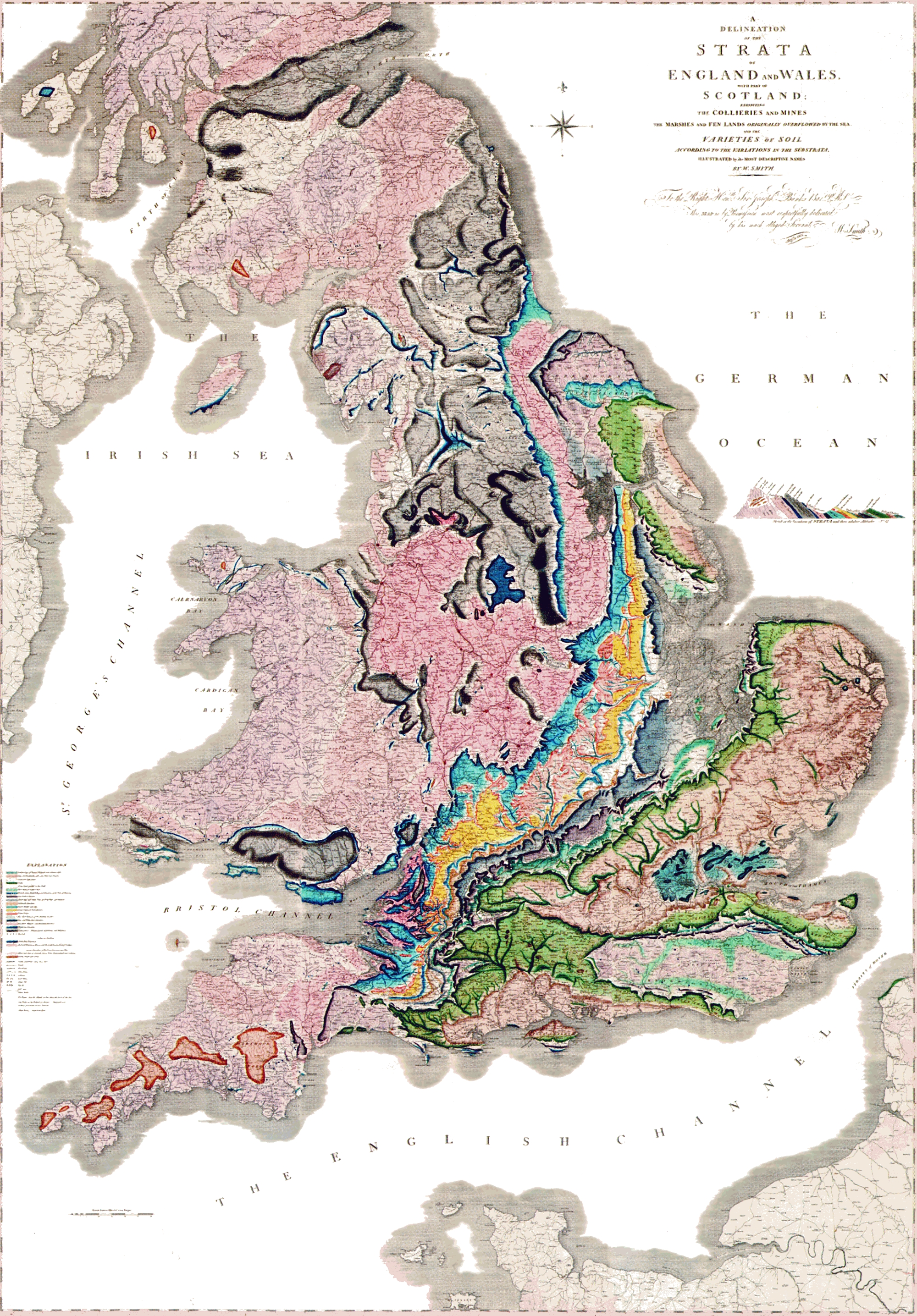
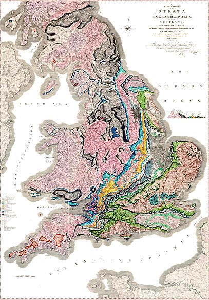
A delineation of the strata of England and Wales with part of Scotland. (The first geological map of Britain, published by William Smith in 1815) |
|||||
| თარიღი | ||||||
| წყარო |
უცნობი العربية: خريطةُ وليام سميث الجيولوجية لإنجلترا وويلز وجنوب اسكتلندا، والتي تم الانتهاء منها في عام 1815م، وتُعتبر ثاني خريطة جيولوجيّة على النطاق الوطني، وكانت أدقَّ خريطةٍ في وقتها |
|||||
| ავტორი | William Smith (1769-1839) | |||||
| უფლება (ფაილის მეორეული გამოყენება) |
|
|||||

ფაილის ისტორია
დააწკაპუნეთ თარიღზე/დროზე, რათა იხილოთ ფაილი, როგორც ის მაშინ გამოიყურებოდა.
| თარიღი/დრო | მინიატიურა | განზომილებები | მომხმარებელი | კომენტარი | |
|---|---|---|---|---|---|
| მიმდინარე | 21:03, 29 მაისი 2024 | | 1 200 × 1 769 (456 კბ) | Anticline (განხილვა | წვლილი) | Reverted to version as of 00:45, 11 December 2008 (UTC) as this image more accurately reflects the colouring and appearance of the map |
| 14:45, 20 ოქტომბერი 2014 |  | 2 000 × 2 871 (4,63 მბ) | Ivtorov (განხილვა | წვლილი) | edited colors, crop. | |
| 00:45, 11 დეკემბერი 2008 |  | 1 200 × 1 769 (456 კბ) | Gump Stump (განხილვა | წვლილი) | {{Information |Description=The first geological map of Britain, published by William Smith in 1815. |Source=[http://www.livescience.com/php/multimedia/imagedisplay/img_display.php?pic=051031_first_map_02.jpg LiveScience Image Gallery] Scan by the Library |
თქვენ არ შეგიძლიათ ამ ფაილზე გადაწერა.
ფაილის გამოყენება
მომდევნო გვერდები იყენებენ ამ ფაილს:
ფაილის გლობალური გამოყენება
ეს ფაილი გამოიყენება შემდეგ ვიკებში:
- გამოყენება ar.wikipedia.org-ში
- გამოყენება bg.wikipedia.org-ში
- გამოყენება bn.wikipedia.org-ში
- გამოყენება ca.wikipedia.org-ში
- გამოყენება de.wikipedia.org-ში
- გამოყენება en.wikipedia.org-ში
- გამოყენება es.wikipedia.org-ში
- გამოყენება fr.wikipedia.org-ში
- გამოყენება fy.wikipedia.org-ში
- გამოყენება gl.wikipedia.org-ში
- გამოყენება he.wikipedia.org-ში
- გამოყენება hy.wikipedia.org-ში
- გამოყენება it.wikipedia.org-ში
- გამოყენება ja.wikipedia.org-ში
- გამოყენება ka.wikipedia.org-ში
იხილეთ, ამ ფაილის გლობალური გამოყენება.