File:Georgia high detail map.png

Πρωτότυπο αρχείο (2.529 × 1.872 εικονοστοιχεία, μέγεθος αρχείου: 340 KB, τύπος MIME: image/png)
Λεζάντες
Λεζάντες

|
This map image could be re-created using vector graphics as an SVG file. This has several advantages; see Commons:Media for cleanup for more information. If an SVG form of this image is available, please upload it and afterwards replace this template with
{{vector version available|new image name}}.
It is recommended to name the SVG file “Georgia high detail map.svg”—then the template Vector version available (or Vva) does not need the new image name parameter. |
Σύνοψη
[επεξεργασία]| Περιγραφή |
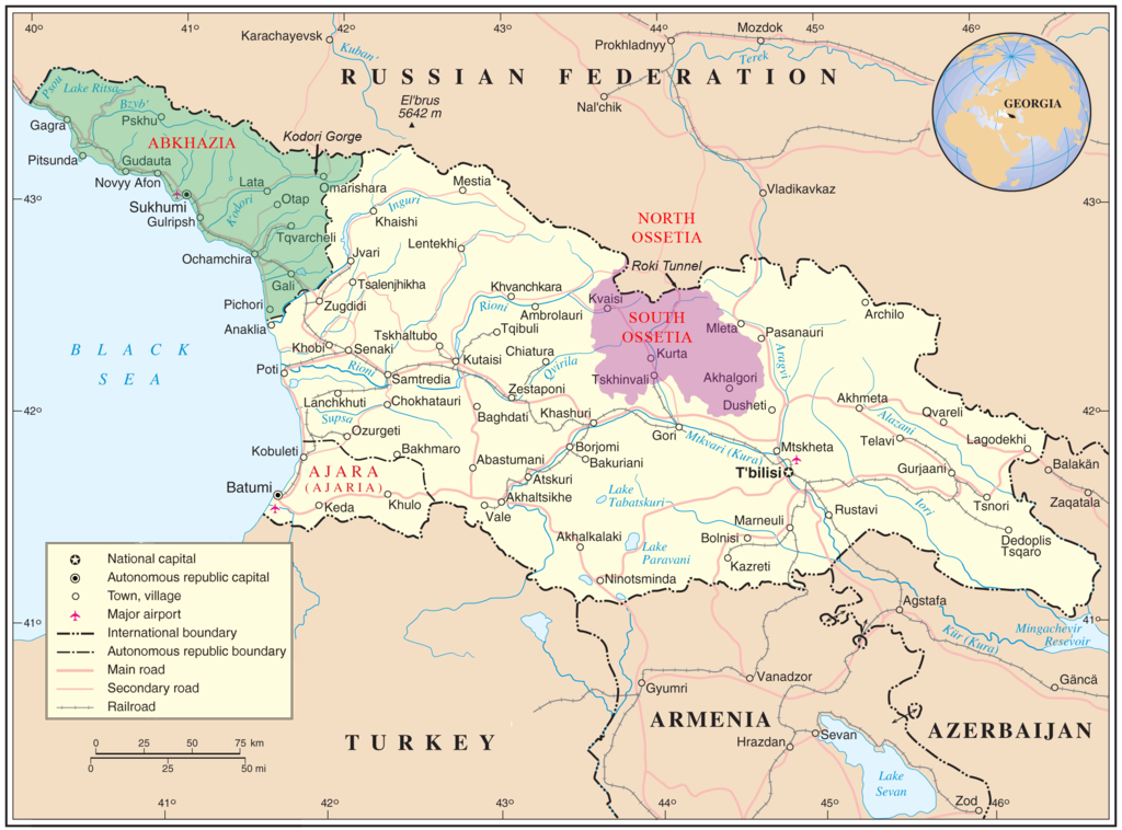
English: Map of Georgia showing the autonomous republics of Abkhazia (de facto independent) and Adjaria, and the de facto independent region of South Ossetia. |
|||
| Ημερομηνία | ||||
| Πηγή | United Nations Cartographic Section, Original unmodified map is at http://www.un.org/Depts/Cartographic/map/profile/georgia.pdf. | |||
| Δημιουργός | United Nations Cartographic Section, with amendments by User:ChrisO | |||
| Άδεια (Επαναχρησιμοποίηση αυτού του αρχείου) |
Public domain | |||
| άλλες εκδόσεις |
|


| This image is a map derived from a United Nations map.
Unless stated otherwise, UN maps are to be considered in the public domain. This applies worldwide. UN maps are, in principle, open source material and you can use them in your work or for making your own map. UN requests however that you delete the UN name, logo and reference number upon any modification to the map. Content of your map will be your responsibility. You can state in your publication, if you wish, something like: based on UN map … (map name, map number, revision number and date). See: Geospatial Information Section. And: Geospatial, location data for a better world. |
 |
Αδειοδότηση
[επεξεργασία]
| Εγώ, ο κάτοχος των πνευματικών δικαιωμάτων αυτού του έργου, δημοσιεύω αυτό το έργο ως κοινό κτήμα. Αυτό ισχύει σε παγκόσμια κλίμακα. Σε ορισμένες χώρες αυτό μπορεί να μην είναι νομικά εφικτό. Αν ναι: Παραχωρώ σε οποιονδήποτε το δικαίωμα να χρησιμοποιήσει αυτό το έργο "για οποιονδήποτε σκοπό", χωρίς κανέναν όρο, εκτός και αν τέτοιοι όροι τίθενται από την νομοθεσία |
Ιστορικό αρχείου
Πατήστε σε μια ημερομηνία/ώρα για να δείτε το αρχείο όπως εμφανιζόταν εκείνη την χρονική στιγμή.
| Ημερομηνία/Ώρα | Μικρογραφία | Διαστάσεις | Χρήστης | Σχόλιο | |
|---|---|---|---|---|---|
| τρέχον | 11:35, 11 Ιανουαρίου 2009 | | 2.529 × 1.872 (340 KB) | Bestalex (συζήτηση | Συνεισφορά) | {{Information |Description= |Source= |Date= |Author= |Permission= |other_versions= }} |
| 20:51, 12 Αυγούστου 2008 |  | 2.529 × 1.872 (330 KB) | ChrisO (συζήτηση | Συνεισφορά) | ||
| 19:12, 12 Αυγούστου 2008 |  | 2.529 × 1.872 (331 KB) | ChrisO (συζήτηση | Συνεισφορά) | {{Information |Description={{en|1=Map of Georgia showing the autonomous republics of Abkhazia and Adjaria, and the breakaway region of South Ossetia. Original unmodified map is at http://www.un.org/Depts/Cartographic/map/profile/georgia.pdf . }} |Source=U |
Δεν μπορείτε να αντικαταστήσετε αυτό το αρχείο.
Χρήση αρχείου
Η ακόλουθη σελίδα χρησιμοποιεί προς αυτό το αρχείο:
Καθολική χρήση αρχείου
Τα ακόλουθα άλλα wiki χρησιμοποιούν αυτό το αρχείο:
- Χρήση σε af.wikipedia.org
- Χρήση σε ar.wikipedia.org
- Χρήση σε azb.wikipedia.org
- Χρήση σε az.wikipedia.org
- Χρήση σε az.wiktionary.org
- Χρήση σε bn.wikipedia.org
- Χρήση σε bxr.wikipedia.org
- Χρήση σε ca.wikipedia.org
- Χρήση σε cs.wikipedia.org
- Χρήση σε cy.wikipedia.org
- Χρήση σε el.wikipedia.org
- Χρήση σε en.wikipedia.org
- Georgia (country)
- South Ossetia
- Georgian–Ossetian conflict
- Roki Tunnel
- Kosovo independence precedent
- Outline of Abkhazia
- Abkhazia
- Talk:Georgia (country)/Archive 5
- User:Kazkaskazkasako/Books/History
- Georgia–Russia border
- Wikipedia:Graphics Lab/Map workshop/Archive/Jul 2014
- User:Mschiffler/sandbox1
- Water supply and sanitation in Georgia
- Proposed Russian annexation of South Ossetia
- User:Royal Georgian/sandbox
- Χρήση σε eo.wikipedia.org
- Χρήση σε es.wikipedia.org
- Χρήση σε et.wikipedia.org
- Χρήση σε fa.wikipedia.org
- Χρήση σε fi.wikipedia.org
- Χρήση σε fi.wikivoyage.org
Δείτε περισσότερη καθολική χρήση αυτού του αρχείου.