File:Georgia high detail map.png

元のファイル (2,529 × 1,872 ピクセル、ファイルサイズ: 340キロバイト、MIME タイプ: image/png)
キャプション
キャプション

|
この地図画像は、ベクターイメージである SVG ファイルとして再作成されるべきです。これにはいくつかの利点があります。詳しくはCommons:Media for cleanupを参照してください。この画像の SVG 形式がすでに利用可能である場合は、アップロードしてください。アップロード後、この画像にあるこのテンプレートを{{Vector version available|新しい画像ファイル名.svg}}テンプレートで置き換えてください。
|
概要
[編集]| 解説 |
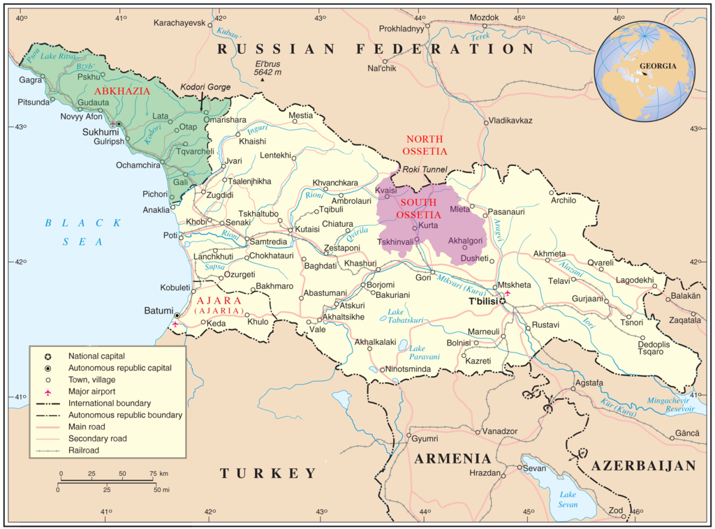
English: Map of Georgia showing the autonomous republics of Abkhazia (de facto independent) and Adjaria, and the de facto independent region of South Ossetia. |
|||
| 日付 | ||||
| 原典 | United Nations Cartographic Section, Original unmodified map is at http://www.un.org/Depts/Cartographic/map/profile/georgia.pdf. | |||
| 作者 | United Nations Cartographic Section, with amendments by User:ChrisO | |||
| 許可 (ファイルの再利用) |
Public domain | |||
| その他のバージョン |
|


| This image is a map derived from a United Nations map.
Unless stated otherwise, UN maps are to be considered in the public domain. This applies worldwide. UN maps are, in principle, open source material and you can use them in your work or for making your own map. UN requests however that you delete the UN name, logo and reference number upon any modification to the map. Content of your map will be your responsibility. You can state in your publication, if you wish, something like: based on UN map … (map name, map number, revision number and date). See: Geospatial Information Section. And: Geospatial, location data for a better world. |
 |
ライセンス
[編集]
| この著作物の著作権者である私は、この著作物における権利を放棄しパブリックドメインとします。これは全世界で適用されます。 一部の国では、これが法的に可能ではない場合があります。その場合は、次のように宣言します。 私は、あらゆる人に対して、法により必要とされている条件を除き、如何なる条件も課すことなく、あらゆる目的のためにこの著作物を使用する権利を与えます。 |
ファイルの履歴
過去の版のファイルを表示するには、その版の日時をクリックしてください。
| 日付と時刻 | サムネイル | 寸法 | 利用者 | コメント | |
|---|---|---|---|---|---|
| 現在の版 | 2009年1月11日 (日) 11:35 | | 2,529 × 1,872 (340キロバイト) | Bestalex (トーク | 投稿記録) | {{Information |Description= |Source= |Date= |Author= |Permission= |other_versions= }} |
| 2008年8月12日 (火) 20:51 |  | 2,529 × 1,872 (330キロバイト) | ChrisO (トーク | 投稿記録) | ||
| 2008年8月12日 (火) 19:12 |  | 2,529 × 1,872 (331キロバイト) | ChrisO (トーク | 投稿記録) | {{Information |Description={{en|1=Map of Georgia showing the autonomous republics of Abkhazia and Adjaria, and the breakaway region of South Ossetia. Original unmodified map is at http://www.un.org/Depts/Cartographic/map/profile/georgia.pdf . }} |Source=U |
このファイルは上書きできません。
ファイルの使用状況
以下のページがこのファイルを使用しています:
グローバルなファイル使用状況
以下に挙げる他のウィキがこの画像を使っています:
- af.wikipedia.org での使用状況
- ar.wikipedia.org での使用状況
- azb.wikipedia.org での使用状況
- az.wikipedia.org での使用状況
- az.wiktionary.org での使用状況
- bn.wikipedia.org での使用状況
- bxr.wikipedia.org での使用状況
- ca.wikipedia.org での使用状況
- cs.wikipedia.org での使用状況
- cy.wikipedia.org での使用状況
- el.wikipedia.org での使用状況
- en.wikipedia.org での使用状況
- Georgia (country)
- South Ossetia
- Georgian–Ossetian conflict
- Roki Tunnel
- Kosovo independence precedent
- Outline of Abkhazia
- Abkhazia
- Talk:Georgia (country)/Archive 5
- User:Kazkaskazkasako/Books/History
- Georgia–Russia border
- Wikipedia:Graphics Lab/Map workshop/Archive/Jul 2014
- User:Mschiffler/sandbox1
- Water supply and sanitation in Georgia
- Proposed Russian annexation of South Ossetia
- User:Royal Georgian/sandbox
- eo.wikipedia.org での使用状況
- es.wikipedia.org での使用状況
- et.wikipedia.org での使用状況
- fa.wikipedia.org での使用状況
- fi.wikipedia.org での使用状況
- fi.wikivoyage.org での使用状況
このファイルのグローバル使用状況を表示する。