File:Geostationaryjava3D.gif
Salta a la navegació
Salta a la cerca
No hi ha cap versió amb una resolució més gran.
Geostationaryjava3D.gif (220 × 220 píxels, mida del fitxer: 227 Ko, tipus MIME: image/gif, en bucle, 183 fotogrames, 14 s)
Llegendes
Llegendes
Afegeix una explicació d'una línia del que representa aquest fitxer
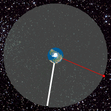
Top View of Geostationary orbit
Resum
[modifica]
| Descripció |
English: Top View of Geostationary orbit. To an observer on the rotating Earth (Africa on the Earth ), the satellite appears stationary in the sky as shown by the yellow radius. A red satellite is also geostationary above its own point on the Earth (Singapore)
http://weelookang.blogspot.com/2010/07/ejs-open-source-geostationary-satellite.html |
| Data | |
| Font | Treball propi |
| Autor | Lookang many thanks to author of original simulation = Francisco Esquembre author of Easy Java Simulation = Francisco Esquembre |
Llicència
[modifica]
Jo, el titular dels drets d'autor d'aquest treball, el public sota la següent llicència:
Aquest fitxer està subjecte a la llicència de Creative Commons Reconeixement i Compartir Igual 3.0 No adaptada.
- Sou lliure de:
- compartir – copiar, distribuir i comunicar públicament l'obra
- adaptar – fer-ne obres derivades
- Amb les condicions següents:
- reconeixement – Heu de donar la informació adequada sobre l'autor, proporcionar un enllaç a la llicència i indicar si s'han realitzat canvis. Podeu fer-ho amb qualsevol mitjà raonable, però de cap manera no suggereixi que l'autor us dóna suport o aprova l'ús que en feu.
- compartir igual – Si modifiqueu, transformeu, o generareu amb el material, haureu de distribuir les vostres contribucions sota una llicència similar o una de compatible com l'original
Historial del fitxer
Cliqueu una data/hora per veure el fitxer tal com era aleshores.
| Data/hora | Miniatura | Dimensions | Usuari/a | Comentari | |
|---|---|---|---|---|---|
| actual | 02:45, 12 juny 2013 | | 220 × 220 (227 Ko) | Lookang (discussió | contribucions) | updated to 2013 version |
| 01:22, 27 juny 2011 |  | 220 × 220 (480 Ko) | Lookang (discussió | contribucions) | Geostationary orbit.To an observer on the rotating Earth (fixed point on the Earth), the satellite appears stationary in the sky. A red satellite is also geostationary above its own point on Earth. Top Down View | |
| 01:14, 27 juny 2011 |  | 280 × 280 (677 Ko) | Lookang (discussió | contribucions) | trying to make the thumbnail animated by using comtasia 7 | |
| 01:08, 27 juny 2011 |  | 280 × 280 (624 Ko) | Lookang (discussió | contribucions) | Geostationary orbit.To an observer on the rotating Earth (fixed point on the Earth), the satellite appears stationary in the sky. A red satellite is also geostationary above its own point on Earth. Top Down View | |
| 01:06, 27 juny 2011 |  | 300 × 300 (625 Ko) | Lookang (discussió | contribucions) | Geostationary orbit.To an observer on the rotating Earth (fixed point on the Earth), the satellite appears stationary in the sky. A red satellite is also geostationary above its own point on Earth. Top Down View. | |
| 00:57, 27 juny 2011 |  | 300 × 300 (653 Ko) | Lookang (discussió | contribucions) |
No podeu sobreescriure aquest fitxer.
Ús del fitxer
La pàgina següent utilitza aquest fitxer:
Ús global del fitxer
Utilització d'aquest fitxer en altres wikis:
- Utilització a af.wikipedia.org
- Utilització a an.wikipedia.org
- Utilització a ar.wikipedia.org
- Utilització a ast.wikipedia.org
- Utilització a bn.wikipedia.org
- Utilització a bs.wikipedia.org
- Utilització a ca.wikipedia.org
- Utilització a en.wikipedia.org
- Utilització a es.wikipedia.org
- Utilització a et.wikipedia.org
- Utilització a fa.wikipedia.org
- Utilització a gl.wikipedia.org
- Utilització a he.wikipedia.org
- Utilització a hi.wikipedia.org
- Utilització a hr.wikipedia.org
- Utilització a hu.wikipedia.org
- Utilització a hy.wikipedia.org
- Utilització a io.wikipedia.org
- Utilització a kn.wikipedia.org
- Utilització a ml.wikipedia.org
- Utilització a ms.wikipedia.org
- Utilització a pl.wikipedia.org
- Utilització a pnb.wikipedia.org
- Utilització a pt.wikipedia.org
- Utilització a ru.wikipedia.org
- Utilització a ru.wikinews.org
- Utilització a simple.wikipedia.org
- Utilització a si.wikipedia.org
- Utilització a sl.wikipedia.org
- Utilització a sr.wikipedia.org
- Utilització a ta.wikipedia.org
- Utilització a te.wikipedia.org
- Utilització a tg.wikipedia.org
- Utilització a th.wikipedia.org
- Utilització a ur.wikipedia.org
- Utilització a vi.wikipedia.org
- Utilització a www.wikidata.org
- Utilització a zh-yue.wikipedia.org
Vegeu més usos globals d'aquest fitxer.