File:Geoviden-1-2011-Nordsøens-geologi.png
Spring til navigation
Spring til søgning
Størrelse af denne forhåndsvisning: 698 × 600 pixels. Andre opløsninger: 279 × 240 pixels | 559 × 480 pixels | 894 × 768 pixels | 1.024 × 880 pixels.
Oprindelig fil (1.024 × 880 billedpunkter, filstørrelse: 212 KB, MIME-type: image/png)
Captions
Captions
Tilføj en kort forklaring på en enkelt linje om hvad filen viser
Beskrivelse[redigér]
| Beskrivelse |
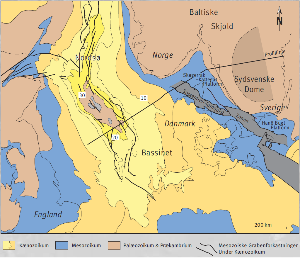
Dansk: Geologiske strukturer i det østlige Nordsø Bassin, side 6 |
| Dato | |
| Kilde | http://geocenter.dk/xpdf/geoviden-1-2011.pdf |
| Forfatter | Ole Graversen |
Licensering[redigér]
This file is licensed under the Creative Commons Attribution-Share Alike 4.0 International license.
- Du må frit:
- at dele – at kopiere, distribuere og overføre værket
- at remixe – at tilpasse værket
- Under følgende vilkår:
- kreditering – Du skal give passende kreditering, angive et link til licensen, og oplyse om der er foretaget ændringer. Du må gøre det på enhver fornuftig måde, men ikke på en måde der antyder at licensgiveren godkender dig eller din anvendelse.
- deling på samme vilkår – Hvis du bearbejder, ændrer eller bygger videre på dette værk, skal du distribuere dine bidrag under den samme eller en kompatibel licens som originalen.

|
This is a file uploaded through the Danish Wikipedia, which has not been reviewed on Commons:
|
Filhistorik
Klik på en dato/tid for at se filen som den så ud på det tidspunkt.
| Dato/tid | Miniaturebillede | Dimensioner | Bruger | Kommentar | |
|---|---|---|---|---|---|
| nuværende | 24. nov. 2016, 15:51 | | 1.024 × 880 (212 KB) | Jensga (diskussion | bidrag) | User created page with UploadWizard |
Du kan ikke overskrive denne fil.
Filanvendelse
Der er ingen sider der bruger denne fil.
Global filanvendelse
Følgende andre wikier anvender denne fil:
- Anvendelser på da.wikipedia.org
Metadata
Kategorier:
- North Sea Basin
- Tectonics maps
- Maps of structural basins
- Danish-language maps
- Structural basins of Europe
- Geological maps of Europe
- Geological maps of Schleswig-Holstein
- Geological maps of Lower Saxony
- Geological maps of Mecklenburg-Vorpommern
- Geological maps of Denmark
- Geological maps of Norway
- Geological maps of Sweden
- Geological maps of England
- Geological maps of the Netherlands
- Geological maps of the Baltic Sea
- Geological maps of the North Sea
- Baltic Shield
- Sorgenfrei-Tornquist Zone
- Denmark Basin