File:Germanic dialects ca. AD 1.png
Przejdź do nawigacji
Przejdź do wyszukiwania

Rozmiar podglądu – 536 × 600 pikseli. Inne rozdzielczości: 215 × 240 pikseli | 429 × 480 pikseli | 687 × 768 pikseli | 915 × 1024 pikseli | 2067 × 2312 pikseli.
Rozmiar pierwotny (2067 × 2312 pikseli, rozmiar pliku: 703 KB, typ MIME: image/png)
Podpisy
Podpisy
Dodaj jednolinijkowe objaśnienie tego, co ten plik pokazuje
| Opis |
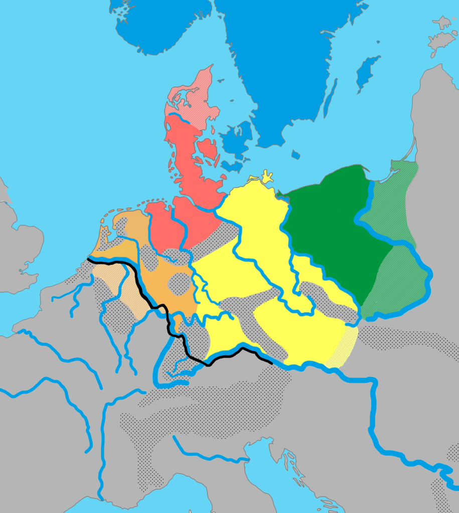
English: The distribution of the primary Germanic dialect groups in Europe around AD 0-100:
|
||
| Data | |||
| Źródło | Based on Germanic Groups ca. 0CE.jpg by Varoon Arya (source used is König, Werner (2001). dtv-Atlas Deutsche Sprache. München: Deutscher Taschenbuch Verlag 2001. ISBN: 3-423-03025-9; pp. 46, 52.), The Indo-European Languages, A G Ramat, P Ramat. Taylor & Francis, 1998. ISBN 041506449X. A Culture Cycle from the Early and Middle Bronze Age. Jan Dobrowski. Archaeologia Polonia. XVI, 1975, Hansjörg Küster: Geschichte des Waldes. Von der Urzeit bis zur Gegenwart. Beck, Munich, 1998, and, The Early Germans, Malcolm Todd (2004). | ||
| Autor | AKAKIOS | ||
| Licencja (Ponowne użycie tego pliku) |
Ten plik jest udostępniany na licencji Creative Commons Uznanie autorstwa – na tych samych warunkach 2.5 zlokalizowana, 2.0 zlokalizowana oraz 1.0 zlokalizowana.
|
||
| Inne wersje |
|

Historia pliku
Kliknij na odpowiedniej dacie/czasie, aby zobaczyć wersję pliku z tamtego okresu.
| Data/czas | Miniatura | Wymiary | Użytkownik | Opis | |
|---|---|---|---|---|---|
| aktualny | 10:28, 30 maj 2024 | | 2067 × 2312 (703 KB) | Vlaemink (dyskusja | edycje) | According to Seebold et al. the Rhine Weser dialects were spoken further east during the 1st century CE. The previous version seems to show a situation closer to the 3rd and 4th century. |
| 15:20, 14 kwi 2022 |  | 2067 × 2312 (776 KB) | Mårtensås (dyskusja | edycje) | Reverted to version as of 11:11, 11 January 2022 (UTC) | |
| 15:18, 14 kwi 2022 |  | 2067 × 2312 (767 KB) | Mårtensås (dyskusja | edycje) | Minor olor fix | |
| 11:11, 11 sty 2022 |  | 2067 × 2312 (776 KB) | Vlaemink (dyskusja | edycje) | This map seems to show a situation closer to 400-600 CE than 1CE, according to Seebold (Seebold, Elmar (2003): Die Herkunft der Franken, Friesen und Sachsen) the Northsea Germanic territories at this point in time did not yet include the Northern Netherlands. | |
| 15:43, 15 paź 2018 |  | 2067 × 2312 (791 KB) | Ax quinque (dyskusja | edycje) | Reverted to version as of 09:48, 4 May 2018 (UTC) Reverted to more detailed version of the map by AKAKIOS. | |
| 11:30, 22 sie 2018 |  | 419 × 431 (15 KB) | Shmurak (dyskusja | edycje) | Reverted to stable version | |
| 09:48, 4 maj 2018 |  | 2067 × 2312 (791 KB) | E-960 (dyskusja | edycje) | Reverted to version as of 20:02, 5 December 2017 (UTC) The other map's boundaries look suspiciously like the boundaries of the Greater Third Reich (see talk page) | |
| 11:12, 30 mar 2018 |  | 419 × 431 (36 KB) | Til Eulenspiegel (dyskusja | edycje) | Reverted to version as of 17:44, 5 December 2017 (UTC) used on 3 pages in am., we never wanted a new version, just make a new file instead of overwrite this one we use | |
| 20:02, 5 gru 2017 |  | 2067 × 2312 (791 KB) | AKAKIOS (dyskusja | edycje) | Reverted to version as of 20:06, 3 December 2017 (UTC) Assuming good faith, while waiting on sources for claims. | |
| 19:58, 5 gru 2017 |  | 2067 × 2312 (816 KB) | AKAKIOS (dyskusja | edycje) | Reverted to version as of 07:50, 4 December 2017 (UTC) |
Nie możesz nadpisać tego pliku.
Lokalne wykorzystanie pliku
Następujące strony korzystają z tego pliku:
- User:Chumwa/OgreBot/Travel and communication maps/2017 December 1-10
- User:Chumwa/OgreBot/Travel and communication maps/2017 February 10-18
- User:Chumwa/OgreBot/Travel and communication maps/2017 November 21-30
- User:Chumwa/OgreBot/Travel and communication maps/2018 August 21-31
- User:Chumwa/OgreBot/Travel and communication maps/2018 March 21-31
- User:Chumwa/OgreBot/Travel and communication maps/2018 May 1-10
- User:Chumwa/OgreBot/Travel and communication maps/2018 October 11-20
- User:Chumwa/OgreBot/Travel and communication maps/2022 April 11-20
- User:Chumwa/OgreBot/Travel and communication maps/2022 January 11-20
- User:Chumwa/OgreBot/Travel and communication maps/2024 May 21-31
Globalne wykorzystanie pliku
Ten plik jest wykorzystywany także w innych projektach wiki:
- Wykorzystanie na af.wikipedia.org
- Wykorzystanie na am.wikipedia.org
- Wykorzystanie na an.wikipedia.org
- Wykorzystanie na ar.wikipedia.org
- Wykorzystanie na be-tarask.wikipedia.org
- Wykorzystanie na bg.wikipedia.org
- Wykorzystanie na cs.wikipedia.org
- Wykorzystanie na de.wikipedia.org
- Wykorzystanie na el.wikipedia.org
- Wykorzystanie na en.wikipedia.org
- Suebi
- Proto-Germanic language
- Talk:Low Franconian
- East Germanic languages
- Ingaevones
- Istvaeones
- North Sea Germanic
- List of Indo-European languages
- Frankish language
- List of early Germanic peoples
- Talk:List of early Germanic peoples
- Elbe Germanic
- Weser–Rhine Germanic
- Dutch language
- User:Kazkaskazkasako/Books/All
- Ingvaeonic nasal spirant law
- North Germanic peoples
- Elbe Germanic peoples
- User:AKAKIOS/sandbox
- Early Germanic culture
- User:Falcaorib/Ancient Empires (01 AD-150 AD)
- Wykorzystanie na es.wikipedia.org
- Wykorzystanie na fa.wikipedia.org
- Wykorzystanie na fi.wikipedia.org
- Wykorzystanie na fr.wikipedia.org
- Wykorzystanie na fy.wikipedia.org
- Wykorzystanie na gl.wikipedia.org
- Wykorzystanie na he.wikipedia.org
- Wykorzystanie na hy.wikipedia.org
- Wykorzystanie na id.wikipedia.org
Pokaż listę globalnego wykorzystania tego pliku.
Metadane
Kategorie:
- East Germanic peoples
- East Germanic languages
- Linguistic maps of Germanic languages
- Maps of the European Iron Age
- Maps of Northern Europe
- Maps of the history of the Netherlands
- Maps of the history of Germany
- Poland in the 1st century
- Old Saxon
- Maps of Przeworsk culture in the 1st century
- Maps of Jastorf culture
- Kinship between human populations
- North Sea Germanic
- Linguistic theories and hypotheses