File:Ghaznavid Empire 975 - 1187 (AD).PNG
Salta a la navegació
Salta a la cerca
No hi ha cap versió amb una resolució més gran.
Ghaznavid_Empire_975_-_1187_(AD).PNG (620 × 428 píxels, mida del fitxer: 20 Ko, tipus MIME: image/png)
Llegendes
Llegendes
Afegeix una explicació d'una línia del que representa aquest fitxer
Resum[modifica]
.PNG&action=edit§ion=1)
| Descripció |
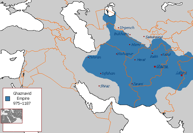
Polski: Państwo Ghaznawidów
English: Ghaznavid Empire |
| Data | |
| Font | Treball propi |
| Autor | Arab League |
| Altres versions | Arabic |
-ar.PNG)
Llicència[modifica]
.PNG&action=edit§ion=2)
| S'ha alliberat aquesta obra al domini públic pel seu autor Arab League de la Viquipèdia en anglès. Això s'aplica a tot el món. En alguns països això pot no ser legalment possible, en tal cas: Arab League concedeix a tothom el dret d'usar aquesta obra per a qualsevol propòsit, sense cap condició llevat d'aquelles requerides per la llei. |
Historial del fitxer
Cliqueu una data/hora per veure el fitxer tal com era aleshores.
.PNG&uselang=ca&dir=prev)
.PNG&uselang=ca&offset=20130607145450)
.PNG&uselang=ca&offset=&limit=20)
.PNG&uselang=ca&offset=&limit=50)
.PNG&uselang=ca&offset=&limit=100)
.PNG&uselang=ca&offset=&limit=250)
.PNG&uselang=ca&offset=&limit=500)
| Data/hora | Miniatura | Dimensions | Usuari/a | Comentari | |
|---|---|---|---|---|---|
| actual | 04:54, 7 jul 2015 | | 620 × 428 (20 Ko) | HistoryofIran (discussió | contribucions) | Of course Iranica doesn't, it states which areas they ruled at their extent, stop making reverts without discussing.. |
| 01:05, 4 jul 2015 |  | 619 × 428 (21 Ko) | Persia10101 (discussió | contribucions) | More accurate map after some research | |
| 01:05, 4 jul 2015 |  | 619 × 428 (21 Ko) | Persia10101 (discussió | contribucions) | More accurate map after some research | |
| 00:58, 4 jul 2015 |  | 620 × 428 (26 Ko) | Persia10101 (discussió | contribucions) | Iranica doesnt show a map. reverting to the more commonly agreed map | |
| 00:57, 4 jul 2015 |  | 620 × 428 (26 Ko) | Persia10101 (discussió | contribucions) | Reverted to version as of 08:05, 14 August 2011 | |
| 12:08, 9 maig 2014 |  | 620 × 428 (20 Ko) | HistoryofIran (discussió | contribucions) | Further fixed the map, i will be adding vassals later. | |
| 23:47, 28 gen 2014 |  | 620 × 428 (20 Ko) | HistoryofIran (discussió | contribucions) | Fars and Kerman remained under Buyid rule until the Seljuqs came. | |
| 15:01, 7 juny 2013 |  | 620 × 428 (20 Ko) | HistoryofIran (discussió | contribucions) | Fixed the map, according to Iranica the map was like this at it's greatest extent. | |
| 14:58, 7 juny 2013 |  | 620 × 428 (20 Ko) | HistoryofIran (discussió | contribucions) | Fixed the map, according to Iranica the map was like this at it's greatest extent. | |
| 14:54, 7 juny 2013 |  | 620 × 428 (20 Ko) | HistoryofIran (discussió | contribucions) | Fixed the map, according to Iranica the map was like this at it's greatest extent. |
No podeu sobreescriure aquest fitxer.
Ús del fitxer
Les 2 pàgines següents utilitzen aquest fitxer:
Ús global del fitxer
Utilització d'aquest fitxer en altres wikis:
- Utilització a arz.wikipedia.org
- Utilització a ast.wikipedia.org
- Utilització a av.wikipedia.org
- Utilització a azb.wikipedia.org
- Utilització a az.wikipedia.org
- Utilització a ba.wikipedia.org
- Utilització a be.wikipedia.org
- Utilització a bg.wikipedia.org
- Utilització a bn.wikipedia.org
- Utilització a ca.wikipedia.org
- Utilització a ceb.wikipedia.org
- Utilització a ckb.wikipedia.org
- Utilització a da.wikipedia.org
- Utilització a de.wikipedia.org
- Utilització a el.wikipedia.org
- Utilització a en.wikipedia.org
- Muslim conquests of Afghanistan
- History of Afghanistan
- Turkic peoples
- Greater Iran
- Jasrota
- User:Arab Hafez/Map
- Portal:Afghanistan
- Shia Islam in the Indian subcontinent
- User:Ottava Rima/Persian Empire
- User:Sobreira/Religion
- Muslim conquest of Khorasan
- Nurpur kingdom
- User:Northamerica1000/Portals of the world
- User:Kansas Bear/Ghaznavids
- User:Kypioys sx/sandbox
- User:Kansas Bear/Saffarid dynasty
- Utilització a eo.wikipedia.org
- Utilització a es.wikipedia.org
Vegeu més usos globals d'aquest fitxer.
.PNG)
.PNG&oldid=524721151)