File:Google Street View coverage.svg
Aller à la navigation
Aller à la recherche

Taille de cet aperçu PNG pour ce fichier SVG : 800 × 403 pixels. Autres résolutions : 320 × 161 pixels | 640 × 323 pixels | 1 024 × 516 pixels | 1 280 × 645 pixels | 2 560 × 1 291 pixels | 845 × 426 pixels.
Fichier d’origine (Fichier SVG, nominalement de 845 × 426 pixels, taille : 1,46 Mio)
Légendes
Légendes
Ajoutez en une ligne la description de ce que représente ce fichier
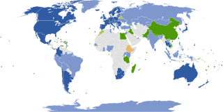
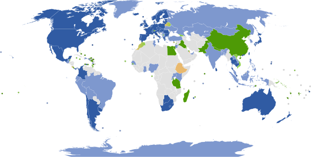
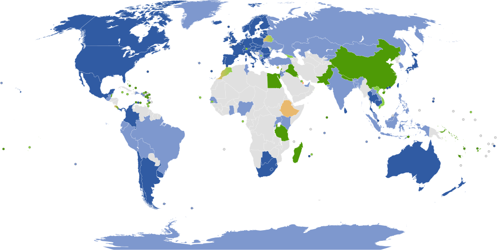
Coverage of Google Street View


|
Il est attendu que cette image soit la plus récente qui existe. N'hésitez pas à la mettre à jour au besoin.
|

|
Ce fichier peut être mis à jour pour contenir de nouvelles informations. Si vous voulez utiliser une version spécifique de ce fichier sans que les mises à jour ne s’affichent, merci d’importer la version en question dans un fichier séparé. |
Legend
[modifier]
English (en): Google Street View coverage
Countries and dependencies with mostly full coverage
Countries and dependencies with partial coverage
Countries and dependencies with full or partial coverage planned (official)
Countries and dependencies with full or partial coverage planned (unofficial)
Countries and dependencies with views of selected businesses and/or tourist attractions only
Countries and dependencies with views of private businesses only
Countries and dependencies with no current or planned coverage
العربية (ar): تغطية جوجل ستريت فيو (Google Street View)
البلدان والتبعيات مع تغطية معظمها كاملة
البلدان والتبعيات مع تغطية جزئية
البلدان والتبعيات المخطط لها لتغطية كاملة أو جزئية (اعلن بشكل رسمي)
البلدان والتبعيات المخطط لها لتغطية كاملة أو جزئية (اعلن بشكل غير رسمي)
البلدان والتبعيات مع إطلالة فقط لشركات مختارة و / أو مزارات سياحية
البلدان والتبعيات مع إطلالة فقك لشرات خاصة
البلدان والتبعيات التي من دون تغطية حالياً أو تغطية مخطط لها
čeština (cs): Pokrytí Street View
Země a území s největším pokrytím Street View
Země a území s částečným pokrytím Street View
Země a území s plánovaným pokrytím Street View (oficiálně)
Země a území s plánovaným pokrytím Street View (neoficiálně)
Země a území s oblastním pokrytím turistických zajímavostí a památek
Countries and dependencies with views of private businesses only
Země a území bez pokrytí Street View
dansk (da): Dækning på Google Street View
Lande og afhængigheder med fuld dækning
Lande og afhængigheder med delvis dækning
Lande og afhængigheder med fuld eller delvis dækning planlagt (officielt)
Lande og afhængigheder med fuld eller delvis dækning planlagt (uofficielt)
Lande og afhængigheder kun med dækning af turist attraktioner
Countries and dependencies with views of private businesses only
Lande og afhængigheder uden nuværende eller planlagt dækning
Deutsch (de): Verfügbarkeit von Google Street View Aufnahmen
Länder, von denen Aufnahmen komplett verfügbar sind
Länder, von denen Aufnahmen teilweise verfügbar sind
Länder, von denen vollständige oder teilweise Aufnahmen geplant sind (offiziell)
Länder, von denen vollständige oder teilweise Aufnahmen geplant sind (inoffiziell)
Länder, in denen nur von Museen Aufnahmen verfügbar sind
Länder, in denen nur Aufnahmen privater Unternehmen verfügbar sind
Länder, von denen Aufnahmen weder verfügbar, noch geplant sind
español (es): Cobertura de Google Street view
Países y dependencias con cobertura mayormente completa
Países y dependencias con cobertura parcial
Países y dependencias con cobertura completa o parcial prevista (oficial)
Países y dependencias con cobertura completa o parcial prevista (no oficial)
Países y dependencias con cobertura solamente de museos
Países y dependencias con cobertura únicamente de negocios
Países y dependencias sin cobertura actual o prevista
suomi (fi): Google Street View -palvelun kattavuus
Maa ja siihen kuuluvat alueet täysin katettuja
Maa ja siihen kuuluvat alueet osittain katettuja
Maa ja siihen kuuluvat alueet aiotaan kuvata täysin tai osittain (virallista tietoa)
Maa ja siihen kuuluvat alueet aiotaan kuvata täysin tai osittain (epävirallista tietoa)
Maa ja siihen kuuluvat alueet on katettu vain tärkeimpien kohteiden osalta
Countries and dependencies with views of private businesses only
Maata ja siihen kuuluvia alueita ei ole eikä ole tarkoitus kattaa lähiaikoina
français (fr): Couverture de Google Street View
Couverture complète
Couverture incomplète
Future (officielle)
Future (non-officielle)
Pays avec musées uniquement
Pays avec entreprises uniquement
Pays non-couvert
עברית (he): מפת כיסוי "גוגל תצוגת רחוב"
מדינות בהן הכיסוי כמעט מלא
מדינות בהן הכיסוי חלקי
מדינות בהן מתוכנן כיסוי מלא או חלקי (רשמי)
מדינות בהן מתוכנן כיסוי מלא או חלקי (לא רשמי)
מדינות בהן מוצגים עסקים ו\או אתרי תיירות נבחרים בלבד
Countries and dependencies with views of private businesses only
מדינות ללא כיסוי קיים או מתוכנן
magyar (hu): A Google Utcakép lefedettsége
Ország vagy függő terület teljes lefedettséggel
Ország vagy függő terület részleges lefedettséggel
Ország vagy függő terület tervezett lefedettséggel (Hivatalos)
Ország vagy függő terület tervezett lefedettséggel (Nem hivatalos)
Ország vagy függő terület, amelynek területén csak múzeumokat lehet megtekinteni
Ország vagy függő terület, amelynek területén csak üzleteket, irodákat és közösségi tereket lehet megtekinteni
Ország vagy függő terület, amelynek területén nincs meglévő vagy tervezett lefedettség sem
italiano (it): La copertura di Google Street View
I paesi e le dipendenze con copertura totale
I paesi e le dipendenze con copertura parziale
I paesi e le dipendenze con prevista copertura totale o parziale (ufficiale)
I paesi e le dipendenze con prevista copertura totale o parziale (non ufficiale)
I paesi e le dipendenze con vista solo dei musei
I paesi e le dipendenze con vista solo delle imprese
I paesi e le dipendenze senza copertura in corso o prevista copertura
日本語 (ja):
利用可能な地域
一部利用可能な地域
サービス開始予定地(公式)
サービス開始予定地(非公式)
博物館のみ利用可能な地域
Countries and dependencies with views of private businesses only
非公開地域
ქართული (ka): Google Street view-ის დაფარვა
ქვეყნები და დამოკიდებული ტერიტორიები სრული დაფარვით
ქვეყნები და დამოკიდებული ტერიტორიები ნაწილობრივი დაფარვით
ქვეყნები და დამოკიდებული ტერიტორიები დაგეგმილი სრული ან ნაწილობრივი დაფარვით (ოფიციალური ინფორმაციით)
ქვეყნები და დამოკიდებული ტერიტორიები დაგეგმილი სრული ან ნაწილობრივი დაფარვით (არაოფიციალური ინფორმაციით)
ქვეყნები და დამოკიდებული ტერიტორიები მხოლოდ მუზეუმების ხედებით
Countries and dependencies with views of private businesses only
ქვეყნები და დამოკიდებული ტერიტორიები დაფარვის გარეშე, მიმდინარე ან დაგეგმილი
lietuvių (lt): Google Street view apimtis
Pilnai apimtos šalys ir priklausomos teritorijos
Nepilnai apimtos šalys ir priklausomos teritorijos
Suplanuota šalių ir priklausomų teritorijų pilna arba nepilna apimtis (oficialiai)
Suplanuota šalių ir priklausomų teritorijų pilna arba nepilna apimtis (neoficialiai)
Šalys ir priklausomos teritorijos tik su muziejų vaizdais
Countries and dependencies with views of private businesses only
Šalys ir priklausomos teritorijos be jokio apimties ar planavimo
polski (pl): Dostępność Google Street View w państwach i terytoriach zależnych
Pokrycie pełne
Pokrycie częściowe
Pokrycie planowane (oficjalnie)
Pokrycie planowane (nieoficjalnie)
Tylko wybrane siedziby firm lub atrakcje turystyczne
Tylko wybrane siedziby firm
Brak pokrycia
português (pt): A cobertura de Google Street View
Países e territórios com cobertura completa
Países e territórios com cobertura parcial
Países e territórios com cobertura completa ou parcial planejada (oficial)
Países e territórios com cobertura completa ou parcial planejada (não oficial)
Países e territórios unicamente com vistas de museus
Countries and dependencies with views of private businesses only
Países e territórios sem cobertura atual ou planejada
русский (ru): Покрытие Google Street view
Страны и зависимые территории с полным покрытием
Страны и зависимые территории с частичным покрытием
Страны и зависимые территории с запланированным полным или частичным покрытием (по официальной информации)
Страны и зависимые территории с запланированным полным или частичным покрытием (по неофициальной информации)
Страны и зависимые территории только с музейными видами или другими туристически привлекательными объектами
Countries and dependencies with views of private businesses only
Страны и зависимые территории без покрытия, текущего либо запланированного
română (ro): Acoperirea Google Street View
Țări și provincii cu acoperire completă
Țări și provincii cu acoperire parțială
Țări și provincii cu acoperire parțială sau completă planificată (oficial)
Țări și provincii cu acoperire parțială sau completă planificată (neoficial)
Țări și provincii cu vizualizare a unor afaceri și/sau obiective turistice alese
Țări și provincii cu vizualizare numai a unor afacerii private
Țări și provincii fără acoperire curentă sau planificată
svenska (sv): Google Street View bevakning
Länder och territorier med full bevakning
Länder och territorier med partiell bevakning
Länder och territorier med planerad full eller partiell bevakning (officiell)
Länder och territorier med planerad full eller partiell bevakning (icke-officiell)
Länder och territorier med bara utsikter från museer
Countries and dependencies with views of private businesses only
Länder och territorier utan aktuell eller planerad bevakning
українська (uk): Покриття Google Street view
Країни та залежні території з повним покриттям
Країни та залежні території з частковим покриттям
Країни та залежні території, що заплановані до повного або часткового покриття (офіційно)
Країни та залежні території, що заплановані до повного або часткового покриття (неофіційно)
Країни та залежні території з фотографіями тільки музеїв або інших туристично привабливих об'єктів
Countries and dependencies with views of private businesses only
Країни та залежні території, що не мають покриття або які не заплановані до покриття
中文 (zh): 谷歌街景覆盖范围
完全被街景覆盖
部分被街景覆盖
计划中完全或部分被街景覆盖(官方)
计划中完全或部分被街景覆盖(非官方)
仅可查看部分旅游景点
僅對私營企業有意見的國家和屬地
不在当前或计划中的覆盖范围内
Türkçe (tr): Google Street View kapsama alanı
Çoğunlukla tam kapsamaya sahip olan ülkeler
Kısmi kapsama alanına sahip ülkeler
Planlanan (resmî) tam veya kısmi kapsamaya sahip ülkeler
Planlanan (gayriresmî) tam veya kısmi kapsamaya sahip ülkeler
Yalnızca turistik manzaralar veya seçilen işletmelerin kapsama alanında olduğu ülkeler
Yalnızca özel işletmelerin görüşüne sahip ülkeler ve bağımlılıklar
Hiçbir geçerli ya da planlanan kapsamaya sahip olmayan ülkeler
íslenska (is): Google Street View umfang
Lönd og landsvæði með löngum heilu umfangi
Lönd og landsvæði með hluta umfangi
Lönd og landsvæði með heliu eða hluta umfangi áætluðu (opinber)
Lönd og landsvæði með heliu eða hluta umfangi áætluðu (óopinber)
Lönd og landsvæði með sýnum yfir bara úrvalsverslanir og/eða ferðamannastaða
Lönd og landsvæði með sýnum yfir bara einkaverslanir
Lönd og landsvæði með engu núverandi eða áætluðu umfangi
Description
[modifier]
| Description |
English: Google Street view coverage |
| Date | |
| Source | Based on file:BlankMap-World6,_compact.svg (PD) and en:Google Street View |
| Auteur | Nandhp |
| Autres versions |
Œuvres dérivées de ce fichier : Google Street View Coverage 9 june 2011.svg Intended to replace File:Google_Street_View.png, which is a raster version of this map. |
Conditions d’utilisation
[modifier]
| Moi, propriétaire des droits d’auteur sur cette œuvre, la place dans le domaine public. Ceci s'applique dans le monde entier. Dans certains pays, ceci peut ne pas être possible ; dans ce cas : J’accorde à toute personne le droit d’utiliser cette œuvre dans n’importe quel but, sans aucune condition, sauf celles requises par la loi. |
Historique du fichier
Cliquer sur une date et heure pour voir le fichier tel qu'il était à ce moment-là.
| Date et heure | Vignette | Dimensions | Utilisateur | Commentaire | |
|---|---|---|---|---|---|
| actuel | 4 avril 2024 à 07:54 | | 845 × 426 (1,46 Mio) | Rtfroot (d | contributions) | Germany is fully shown now; also Panama |
| 1 avril 2024 à 13:55 |  | 845 × 426 (1,46 Mio) | Rtfroot (d | contributions) | +Kazakhstan | |
| 4 octobre 2022 à 21:31 |  | 845 × 426 (1,46 Mio) | Szyign (d | contributions) | Rwanda got added, Vietnam is no longer available, added Cyprus and Ethiopia as unofficial future new countries that got reported by media. Qatar is now officially confirmed by Google as a future new country. | |
| 23 septembre 2022 à 08:34 |  | 845 × 426 (1,46 Mio) | Ibrahim Muizzuddin (d | contributions) | India | |
| 30 mai 2021 à 15:55 |  | 845 × 426 (1,46 Mio) | JSeb05 (d | contributions) | Eliminating unsourced information (2) | |
| 30 mai 2021 à 15:46 |  | 845 × 426 (1,46 Mio) | JSeb05 (d | contributions) | Eliminating unsourced information | |
| 5 octobre 2020 à 06:32 |  | 845 × 426 (1,46 Mio) | Eray08yigit (d | contributions) | Vietnam, Dominic Rebuplic, Austria | |
| 11 février 2020 à 01:39 |  | 845 × 426 (1,46 Mio) | Numberguy6 (d | contributions) | The Gambia | |
| 2 janvier 2020 à 07:45 |  | 845 × 426 (1,46 Mio) | Achemish (d | contributions) | Changed Armenia to light blue (accidentally uploaded unchanged version in my last edit) | |
| 2 janvier 2020 à 07:38 |  | 845 × 426 (1,46 Mio) | Achemish (d | contributions) | Changed Armenia to light blue, as a local company has provided partial coverage across Armenia (and Artsakh) |
Vous ne pouvez pas remplacer ce fichier.
Utilisations locales du fichier
Les 52 pages suivantes utilisent ce fichier :
- User:Chumwa/OgreBot/Travel and communication maps/2016 April 21-30
- User:Chumwa/OgreBot/Travel and communication maps/2016 August 1-10
- User:Chumwa/OgreBot/Travel and communication maps/2016 August 21-31
- User:Chumwa/OgreBot/Travel and communication maps/2016 December 1-10
- User:Chumwa/OgreBot/Travel and communication maps/2016 December 21-31
- User:Chumwa/OgreBot/Travel and communication maps/2016 July 1-10
- User:Chumwa/OgreBot/Travel and communication maps/2016 June 1-10
- User:Chumwa/OgreBot/Travel and communication maps/2016 June 11-20
- User:Chumwa/OgreBot/Travel and communication maps/2016 March 11-20
- User:Chumwa/OgreBot/Travel and communication maps/2016 March 21-31
- User:Chumwa/OgreBot/Travel and communication maps/2016 May 1-10
- User:Chumwa/OgreBot/Travel and communication maps/2016 November 1-10
- User:Chumwa/OgreBot/Travel and communication maps/2016 November 11-20
- User:Chumwa/OgreBot/Travel and communication maps/2016 October 11-20
- User:Chumwa/OgreBot/Travel and communication maps/2016 October 21-31
- User:Chumwa/OgreBot/Travel and communication maps/2016 September 1-10
- User:Chumwa/OgreBot/Travel and communication maps/2016 September 11-20
- User:Chumwa/OgreBot/Travel and communication maps/2016 September 21-30
- User:Chumwa/OgreBot/Travel and communication maps/2017 April 1-10
- User:Chumwa/OgreBot/Travel and communication maps/2017 April 1/Overflow 1
- User:Chumwa/OgreBot/Travel and communication maps/2017 April 21-30
- User:Chumwa/OgreBot/Travel and communication maps/2017 December 11-20
- User:Chumwa/OgreBot/Travel and communication maps/2017 February 1-9
- User:Chumwa/OgreBot/Travel and communication maps/2017 February 10-18
- User:Chumwa/OgreBot/Travel and communication maps/2017 July 21-31
- User:Chumwa/OgreBot/Travel and communication maps/2017 June 11-20
- User:Chumwa/OgreBot/Travel and communication maps/2017 March 11-20
- User:Chumwa/OgreBot/Travel and communication maps/2017 November 1-10
- User:Chumwa/OgreBot/Travel and communication maps/2017 October 21-31
- User:Chumwa/OgreBot/Travel and communication maps/2017 September 11-20
- User:Chumwa/OgreBot/Travel and communication maps/2018 April 11-20
- User:Chumwa/OgreBot/Travel and communication maps/2018 August 11-20
- User:Chumwa/OgreBot/Travel and communication maps/2018 December 11-20
- User:Chumwa/OgreBot/Travel and communication maps/2018 January 11-20
- User:Chumwa/OgreBot/Travel and communication maps/2018 January 21-31
- User:Chumwa/OgreBot/Travel and communication maps/2018 July 11-20
- User:Chumwa/OgreBot/Travel and communication maps/2018 July 21-31
- User:Chumwa/OgreBot/Travel and communication maps/2018 June 1-10
- User:Chumwa/OgreBot/Travel and communication maps/2018 May 21-31
- User:Chumwa/OgreBot/Travel and communication maps/2018 October 11-20
- User:Chumwa/OgreBot/Travel and communication maps/2018 September 11-20
- User:Chumwa/OgreBot/Travel and communication maps/2020 February 10-19
- User:Chumwa/OgreBot/Travel and communication maps/2020 January 1-10
- User:Chumwa/OgreBot/Travel and communication maps/2020 October 1-10
- User:Chumwa/OgreBot/Travel and communication maps/2021 May 21-31
- User:Chumwa/OgreBot/Travel and communication maps/2022 October 1-10
- User:Chumwa/OgreBot/Travel and communication maps/2022 September 21-30
- User:Chumwa/OgreBot/Travel and communication maps/2024 April 1-10
- File:Google Street View.svg
- File:Google Street View Coverage 9 june 2011.svg
- Category:Google Street View
Utilisations du fichier sur d’autres wikis
Les autres wikis suivants utilisent ce fichier :
- Utilisation sur ar.wikipedia.org
- Utilisation sur ast.wikipedia.org
- Utilisation sur bg.wikipedia.org
- Utilisation sur ckb.wikipedia.org
- Utilisation sur cs.wikipedia.org
- Utilisation sur da.wikipedia.org
- Utilisation sur de.wikipedia.org
- Utilisation sur el.wikipedia.org
- Utilisation sur en.wikipedia.org
- Utilisation sur es.wikipedia.org
- Utilisation sur et.wikipedia.org
- Utilisation sur eu.wikipedia.org
- Utilisation sur fa.wikipedia.org
- Utilisation sur fi.wikipedia.org
- Utilisation sur fr.wikipedia.org
- Utilisation sur he.wikipedia.org
- Utilisation sur hu.wikipedia.org
- Utilisation sur hy.wikipedia.org
- Utilisation sur id.wikipedia.org
- Utilisation sur it.wikipedia.org
- Utilisation sur ja.wikipedia.org
- Utilisation sur kk.wikipedia.org
- Utilisation sur ko.wikipedia.org
- Utilisation sur lt.wikipedia.org
- Utilisation sur ms.wikipedia.org
- Utilisation sur no.wikipedia.org
- Utilisation sur pl.wikipedia.org
- Utilisation sur pt.wikipedia.org
- Utilisation sur ru.wikipedia.org
- Utilisation sur sk.wikipedia.org
- Utilisation sur th.wikipedia.org
- Utilisation sur tr.wikipedia.org
- Utilisation sur uk.wikipedia.org
- Utilisation sur www.wikidata.org
- Utilisation sur zh-yue.wikipedia.org
- Utilisation sur zh.wikipedia.org