File:Grafschaft Mark 1791 Friedrich C Mueller.jpg
跳至導覽
跳至搜尋
預覽大小:677 × 599 像素。 其他解析度:271 × 240 像素 | 542 × 480 像素 | 867 × 768 像素 | 1,157 × 1,024 像素 | 2,033 × 1,800 像素。
原始檔案 (2,033 × 1,800 像素,檔案大小:1.32 MB,MIME 類型:image/jpeg)
說明
說明
添加單行說明來描述出檔案所代表的內容
|

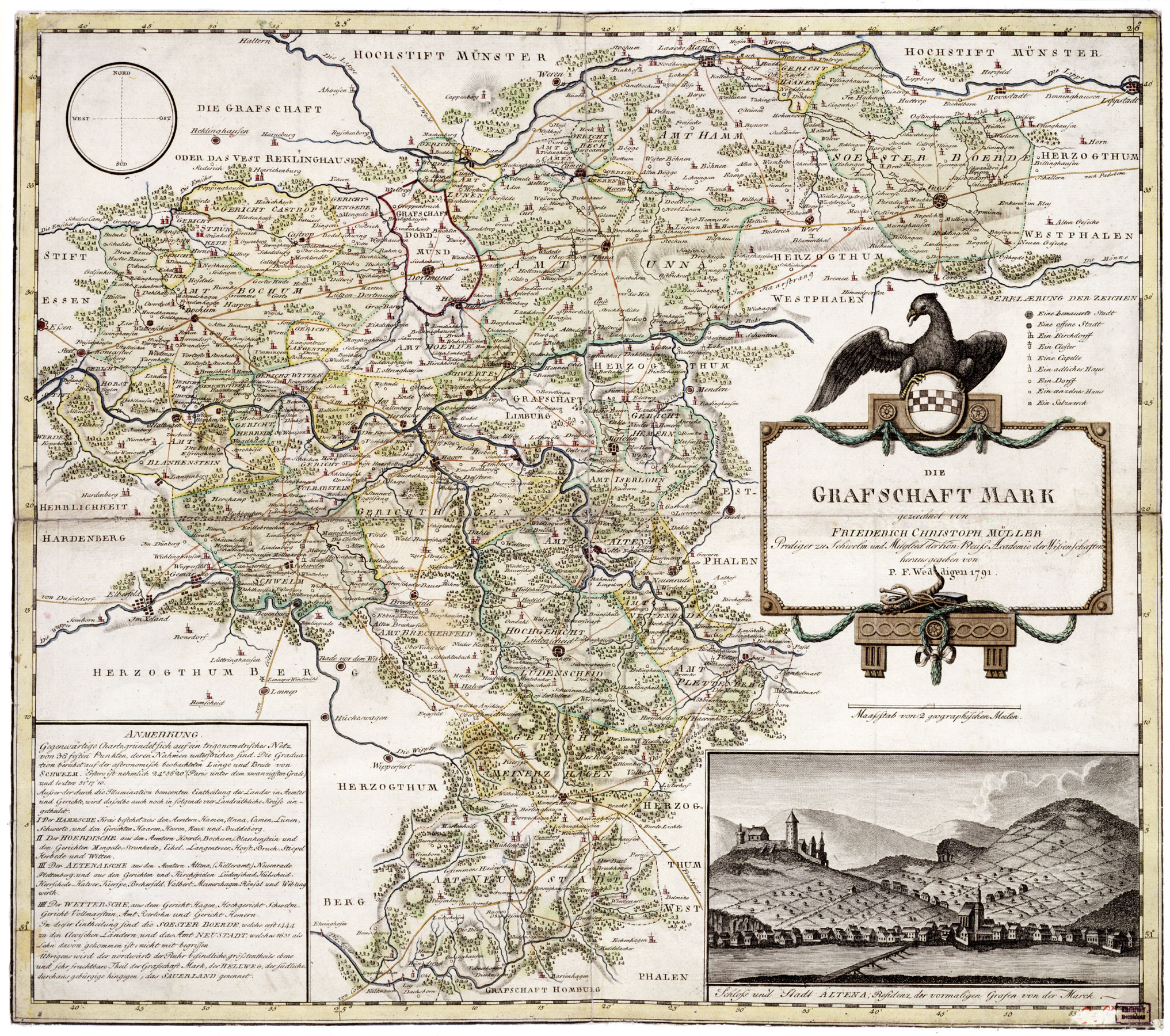
This image was selected as picture of the day on Wikimedia Commons for 22 June 2007. It was captioned as follows: English: Map of County of Mark, Germany, 1791, by Friederich Christoph Müller. Other languages:
Afrikaans: Die graafskap Mark in Duitsland, 1791, deur Friederich Christoph Müller Čeština: Mapa zaniklého německého státu Marka Grafschaft Mark z roku 1791 od Friedricha Christopha Müllera. English: Map of County of Mark, Germany, 1791, by Friederich Christoph Müller. Español: Mapa del Condado de Mark, Alemania, 1791, hecho por Friederich Christoph Müller. Esperanto: Mapo de la graflando de Mark, Germanio (1791), de Friederich Christoph Müller. Français : Carte du comté de la Marck, 1791, par Friedrich Christoph Müller. Magyar: A Marki Grófság térképe, Németország, 1791, készítette Friederich Christoph Müller. Nederlands: Kaart van het Duitse Graafschap Mark (Friederich Christoph Müller, 1791) Polski: Mapa hrabstwa Mark, Rzesza Niemiecka (1791). Wykonana przez Friedericha Christopha Müllera Română: Harta comitatului Mark, Germania, 1791, de Friederich Christoph Müller. Slovenčina: Mapa nemeckého panstva Grafschaft Mark z roku 1791 od Friedricha Christopha Müllera. Svenska: Karta över grevskapet Mark i nuvarande Tyskland, ritad av Friederich Christoph Müller, 1791. Беларуская: Карта графства Марка, былой краіны ў Свяшчэннай Рымскай імперыі (Фрыдрых Крыстаф Мюлер, 1791) Русский: Карта графства Марк, Германия (Фридрих Христоф Мюллер, 1791) 中文: 1791年绘制的德国马克县地图。 中文(繁體): 弗里德里希·克里斯托夫·穆勒在1791年繪製的馬克伯爵領地地圖 العربية : خريطة لمقاطعة مارك في ألمانيا في عام 1791 وضعها فريدريك كريستوف مولر. |
摘要
[編輯]
| 描述 | Map of Grafschaft Mark (County of Mark), Germany, 1791, by Friedrich Christoph Müller |
| 日期 | |
| 來源 | http://www.lwl.org/westfaelische-geschichte/ |
| 作者 | Friedrich Christoph Müller |
| 授權許可 (重用此檔案) |
Public Domain |
授權條款
[編輯]
|
本作品在其來源國以及其他版權期限是作者逝世後70年或以下的國家與地區屬於公有領域。
| |
| 此作品無已知的著作權限制,亦不受所有相關和鄰接的權利限制。 | |
檔案歷史
點選日期/時間以檢視該時間的檔案版本。
| 日期/時間 | 縮圖 | 尺寸 | 用戶 | 備註 | |
|---|---|---|---|---|---|
| 目前 | 2007年1月8日 (一) 22:01 | | 2,033 × 1,800(1.32 MB) | Simplicius(對話 | 貢獻) | Map of Grafschaft Mark, Germany, 1791, by Friederich Christoph Müller, Public Domain {{PD-old}} Category:1791 |
無法覆蓋此檔案。
檔案用途
下列50個頁面有用到此檔案:
- User:Hedorfer/Sandbox
- User:Holger1959/Spielwiese
- User:Pfctdayelise/POTY07 categories/2007 list
- User:Pfctdayelise/POTY07 categories/Diagrams, coats of arms, art and illustrations
- User talk:SvonHalenbach
- Commons:Featured picture candidates/Image:Grafschaft Mark 1791 Friedrich C Mueller.jpg
- Commons:Featured picture candidates/Log/January 2007
- Commons:Featured pictures/Non-photographic media/Maps
- Commons:Featured pictures/chronological/2007-A
- Commons:Picture of the Year/2007/Galleries/All
- Commons:Picture of the Year/2007/Galleries/Graphic art and maps
- Commons:Picture of the Year/2007/Results/Round 1/Gallery
- Commons:Potd/2007-06 (de)
- Commons:Potd/2007-06 (eo)
- Commons:Potd/2007-06 (fr)
- Commons:Potd/2007-06 (nl)
- Commons:Potd/2007-06 (pl)
- Commons:Potd/2007-06 (pt)
- Commons:Potd/2007-06 (ro)
- Commons:Potd/2007-06 (ru)
- Commons:Potd/2007-06 (tr)
- Commons:Potd/2007-06 (uk)
- Commons:Potd/2007-06 (zh-hant)
- Commons talk:Featured picture candidates/Archive candidate list
- File:Grafschaft Mark 1791 Friedrich C Mueller Ausschnitt Beyenburger Brücke.jpg
- Template:Potd/2007-06
- Template:Potd/2007-06-22
- Template:Potd/2007-06-22 (af)
- Template:Potd/2007-06-22 (ar)
- Template:Potd/2007-06-22 (be)
- Template:Potd/2007-06-22 (cs)
- Template:Potd/2007-06-22 (de)
- Template:Potd/2007-06-22 (en)
- Template:Potd/2007-06-22 (eo)
- Template:Potd/2007-06-22 (es)
- Template:Potd/2007-06-22 (fr)
- Template:Potd/2007-06-22 (hu)
- Template:Potd/2007-06-22 (it)
- Template:Potd/2007-06-22 (ja)
- Template:Potd/2007-06-22 (nl)
- Template:Potd/2007-06-22 (pl)
- Template:Potd/2007-06-22 (pt)
- Template:Potd/2007-06-22 (ro)
- Template:Potd/2007-06-22 (ru)
- Template:Potd/2007-06-22 (sk)
- Template:Potd/2007-06-22 (sv)
- Template:Potd/2007-06-22 (zh-hans)
- Template:Potd/2007-06-22 (zh-hant)
- Template:Potd/2007-06 (pl)
- Template:Potd/2007-06 (zh-hans)
全域檔案使用狀況
以下其他 wiki 使用了這個檔案:
- af.wikipedia.org 的使用狀況
- ast.wikipedia.org 的使用狀況
- ba.wikipedia.org 的使用狀況
- br.wikipedia.org 的使用狀況
- de.wikipedia.org 的使用狀況
- en.wikipedia.org 的使用狀況
- en.wikisource.org 的使用狀況
- eo.wikipedia.org 的使用狀況
- es.wikipedia.org 的使用狀況
- et.wikipedia.org 的使用狀況
- eu.wiktionary.org 的使用狀況
- hu.wikipedia.org 的使用狀況
- ia.wikipedia.org 的使用狀況
- it.wikipedia.org 的使用狀況
- ko.wikipedia.org 的使用狀況
- ms.wikipedia.org 的使用狀況
- nl.wikipedia.org 的使用狀況
- os.wikipedia.org 的使用狀況
- pl.wikipedia.org 的使用狀況
- pl.wiktionary.org 的使用狀況
- pt.wikipedia.org 的使用狀況
- ru.wikipedia.org 的使用狀況
- ru.wikinews.org 的使用狀況
- sah.wikipedia.org 的使用狀況
- tr.wikipedia.org 的使用狀況
- uk.wikipedia.org 的使用狀況
- vi.wikipedia.org 的使用狀況
- zh.wikipedia.org 的使用狀況