File:Great Salt Lake ISS 2003.jpg
Pāriet uz navigāciju
Pāriet uz meklēšanu
Šī priekšskata izmērs: 612 × 600 pikseļi. Citi izmēri: 245 × 240 pikseļi | 490 × 480 pikseļi | 996 × 976 pikseļi.
Sākotnējais fails (996 × 976 pikseļi, faila izmērs: 248 KB, MIME tips: image/jpeg)
Captions
Captions
Pievieno vienas rindiņas aprakstu, ko šis fails attēlo
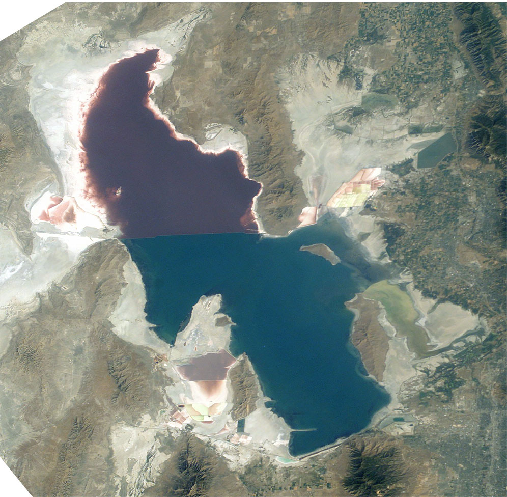
The Great Salt Lake (an endorheic lake) in Utah, taken from the International space station.
Great Salt Lake from German Wikipedia
- Description:
- Great Salt Lake, Utah, to the right (east) are the Wasatch Mountains, to the lower right is Salt Lake City, Utah. This photo is taken from the International Space Station from approximately 380 km. The railway clearly separates the north and south sections of the lake, which have different salt concentrations due to the barrier. The northern section ( Gunnison Bay) is at least two times more salty than the southern one, and shows a pink or mauve color. The water level of the lake is very low: note that the northeast arm of the lake has disappeared, and that Antelope Island is no longer an island at all.
- Sequence of landforms (west-to-east), north:
en:Curlew Valley, en:Hansel Mountains, Hansel Valley, North Promontory Mountains, en:Blue Creek Valley, Blue Spring Hills, Penrose-Bothwell, Utah - Islands:
en:Stansbury Island, en:Antelope Island, en:Fremont Island-(north) - Sequence, south:
(en:Lakeside Mountains), en:Cedar Mountains (Tooele County), en:Skull Valley (Utah), en:Stansbury Mountains, Tooele Valley, en:Oquirrh Mountains, SLC - West lake: en:Hogup Mountains, (northwest), en:Lakeside Mountains, (southwest)
- Lake center: en:Promontory Mountains
- Sequence of landforms (west-to-east), north:
- Date: 19 August 2003, GMT time: 16:37
- Colors adapted: geographically coded
- Great Salt Lake, Utah, to the right (east) are the Wasatch Mountains, to the lower right is Salt Lake City, Utah. This photo is taken from the International Space Station from approximately 380 km. The railway clearly separates the north and south sections of the lake, which have different salt concentrations due to the barrier. The northern section ( Gunnison Bay) is at least two times more salty than the southern one, and shows a pink or mauve color. The water level of the lake is very low: note that the northeast arm of the lake has disappeared, and that Antelope Island is no longer an island at all.
- Source:
- NASA's Earth Observatory [1]
- License:
| This file is in the public domain in the United States because it was solely created by NASA. NASA copyright policy states that "NASA material is not protected by copyright unless noted". (See Template:PD-USGov, NASA copyright policy page or JPL Image Use Policy.) | ||
 |
Warnings:
|
From : http://en.wikipedia.org/wiki/Image:Great_Salt_Lake_ISS_2003.JPG
| Annotations | This image is annotated: View the annotations at Commons |
Faila hronoloģija
Uzklikšķini uz datums/laiks kolonnā esošās saites, lai apskatītos, kā šis fails izskatījās tad.
| Datums/Laiks | Attēls | Izmēri | Dalībnieks | Komentārs | |
|---|---|---|---|---|---|
| tagadējais | 2005. gada 11. novembris, plkst. 09.09 | | 996 × 976 (248 KB) | Urban~commonswiki (diskusija | devums) | Great Salt Lake from German Wikipedia * Description: ** Great Salt Lake, Utah, to the right (east) are the Wasatch Mountains, to the lower right is Salt Lake City, Utah. This photo is taken from the International Space Station from a |
Šo failu nevar pārrakstīt.
Faila lietojums
Šo failu izmanto šajā 1 lapā:
Globālais faila lietojums
Šīs Vikipēdijas izmanto šo failu:
- Izmantojums ar.wikipedia.org
- Izmantojums arz.wikipedia.org
- Izmantojums az.wikipedia.org
- Izmantojums be.wikipedia.org
- Izmantojums bn.wikipedia.org
- Izmantojums br.wikipedia.org
- Izmantojums ceb.wikipedia.org
- Izmantojums cv.wikipedia.org
- Izmantojums da.wikipedia.org
- Izmantojums de.wikipedia.org
- Izmantojums el.wikipedia.org
- Izmantojums en.wikipedia.org
- Jim Bridger
- Endorheic basin
- User:Cool Hand Luke/Photos
- Portal:United States/Selected article/2006, week 37
- Portal:United States/Selected article/2006, week 38
- Portal:United States/Selected article/2006, week 39
- Portal:United States/Selected article/2006, week 40
- Wikipedia:WikiProject Lakes/Galleries/1
- Endorheic lake
- Blue Creek Valley
- Izmantojums eo.wikipedia.org
- Izmantojums es.wikipedia.org
- Izmantojums et.wikipedia.org
- Izmantojums fa.wikipedia.org
- Izmantojums fi.wikipedia.org
- Izmantojums fr.wikipedia.org
- Grand Lac Salé
- Lac Bonneville
- Wikipédia:Lumière sur/Juin 2008
- Wikipédia:Lumière sur/Grand Lac Salé
- Wikipédia:Sélection/Géographie
- Wikipédia:Sélection/Eau
- Wikipédia:Sélection/Utah
- Portail:Information géographique/Sélection
- Wikipédia:Sélection/Lacs et cours d'eau
- Portail:Salt Lake City
- Wikipédia:Sélection/Salt Lake City
- Wikipédia:Sélection/États-Unis/Bons articles/Partie II
- Julie Moschelesová
- Izmantojums he.wikipedia.org
- Izmantojums hi.wikipedia.org
- Izmantojums hu.wikipedia.org
- Izmantojums hy.wikipedia.org
- Izmantojums id.wikipedia.org
Skatīt šī faila pilno globālo izmantojumu.
Metadati
Kategorijas:
- Satellite pictures of Great Salt Lake
- Landforms bordering the Great Salt Lake
- Promontory Mountains
- Antelope Island
- Stansbury Island
- Fremont Island
- Hogup Mountains
- Curlew Valley
- Hansel Mountains
- North Promontory Mountains
- Blue Creek Valley
- Lakeside Mountains
- Puddle Valley
- Grassy Mountains
- Ripple Valley
- Cedar Mountains (Tooele County)
- Skull Valley (Utah)
- Stansbury Mountains
- Tooele Valley
- Oquirrh Mountains
- Pink lakes
- Lucin Cutoff