File:Greater Croatia 01.png
ナビゲーションに移動
検索に移動
このプレビューのサイズ: 663 × 600 ピクセル。 その他の解像度: 265 × 240 ピクセル | 531 × 480 ピクセル | 849 × 768 ピクセル | 1,151 × 1,041 ピクセル。
元のファイル (1,151 × 1,041 ピクセル、ファイルサイズ: 153キロバイト、MIME タイプ: image/png)
キャプション
キャプション
このファイルの内容を1行で記述してください
概要[編集]
| 解説 |
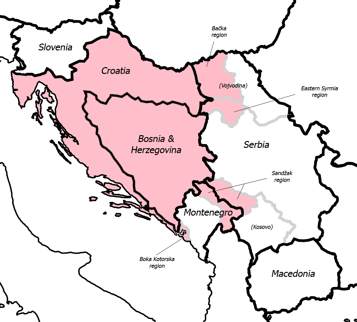
English: Fixed some detail, used overlaid Sandzak, Backa & Syrmium regions so it's much more accurate now. Pink coloring denotes regions claimed by Greater Croatian proponents. Current country borders are black, regional borders (only those that are relevant to the article) are grey.
CommentMap is still wrong:) Croatian-Slovenian border in Istria is 20 kilometars southern that it should be (Umag and Savudrija are in Croatia, hej!) And borders of eastern Srijem are not correct (Zemun and Novi Beograd are part of Srijem, too).
|
| 日付 | 2006年5月24日 (当初のアップロード日) |
| 原典 | en.wikipedia からコモンズに移動されました。 |
| 作者 | 英語版ウィキペディアのDr.Gonzoさん |
| その他のバージョン |
|


ライセンス[編集]
| この著作物は、著作者である英語版ウィキペディアのDr.Gonzoさんによって権利が放棄され、パブリックドメインとされました。これは全世界で適用されます。 一部の国では、これが法的に可能ではない場合があります。その場合は、次のように宣言します。 Dr.Gonzoは、あらゆる人に対して、法により必要とされている条件を除き、如何なる条件も課すことなく、あらゆる目的のためにこの著作物を使用する権利を与えます。 |
元のアップロードログ[編集]
元のファイルページはこちら。以下の利用者は全てen.wikipediaに属します。
- 2007-03-13 10:42 Dr.Gonzo 1151×1041×8 (156832 bytes) Fixed the Istria border (sorry for that, the blank map I used already had that mistake)
- 2006-05-24 22:25 Dr.Gonzo 1151×1041×8 (154088 bytes) Fixed some detail, used overlayed Sandzak, Backa & Syrmium regions so it's much more accurate now.
- 2006-05-24 19:10 Dr.Gonzo 1151×1041×8 (153078 bytes) First version, self made. Some minor geographical detail may be incorrect. Pink coloring denotes regions claimed by Greater Croatian proponents.
ファイルの履歴
過去の版のファイルを表示するには、その版の日時をクリックしてください。
| 日付と時刻 | サムネイル | 寸法 | 利用者 | コメント | |
|---|---|---|---|---|---|
| 現在の版 | 2008年2月25日 (月) 22:40 | | 1,151 × 1,041 (153キロバイト) | File Upload Bot (Magnus Manske) (トーク | 投稿記録) | {{BotMoveToCommons|en.wikipedia}} {{Information |Description={{en|Fixed some detail, used overlaid Sandzak, Backa & Syrmium regions so it's much more accurate now. Pink coloring denotes regions claimed by Greater Croatian proponents. Current country bord |
このファイルは上書きできません。
ファイルの使用状況
以下の 5 ページがこのファイルを使用しています:
グローバルなファイル使用状況
以下に挙げる他のウィキがこの画像を使っています:
- ar.wikipedia.org での使用状況
- bs.wikipedia.org での使用状況
- cs.wikipedia.org での使用状況
- de.wikipedia.org での使用状況
- el.wikipedia.org での使用状況
- en.wikipedia.org での使用状況
- id.wikipedia.org での使用状況
- ja.wikipedia.org での使用状況
- pt.wikipedia.org での使用状況
- sh.wikipedia.org での使用状況
- sr.wikipedia.org での使用状況
- uk.wikipedia.org での使用状況
- www.wikidata.org での使用状況