File:Greater Manchester Satelite View bright.png
跳转到导航
跳转到搜索

本预览的尺寸:800 × 527像素。 其他分辨率:320 × 211像素 | 640 × 421像素 | 992 × 653像素。
原始文件 (992 × 653像素,文件大小:1.52 MB,MIME类型:image/png)
说明
说明
添加一行文字以描述该文件所表现的内容
摘要
[编辑]
| 描述 | |
| 来源 | Satellite imagery taken from NASA World Wind software (by screenshot) |
| 作者 | 相片: NASA |
许可协议
[编辑]
| 本图像属于 w:公有领域 ,因其为 NASA 的 World Wind 卫星地图浏览器的一张截图,且使用了公有领域图层,如 Blue Marble、MODIS、Landsat、SRTM、USGS、GLOBE 等。
|
 |
原始上传日志
[编辑]
The original description page was here. All following user names refer to en.wikipedia.
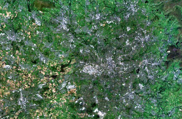
- 2008-03-20 23:06 Mr Stephen 992×653×8 (1589953 bytes) ==Summary== [[NASA]] satelite image of the [[Greater Manchester]] county and conurbation. ==Licencing== {{PD-WorldWind}} [[Category:Maps of Greater Manchester]] [[Category:Manchester]] [[Category:Greater Manchester]]
文件历史
点击某个日期/时间查看对应时刻的文件。
| 日期/时间 | 缩略图 | 大小 | 用户 | 备注 | |
|---|---|---|---|---|---|
| 当前 | 2008年6月26日 (四) 21:45 | | 992 × 653(1.52 MB) | File Upload Bot (Magnus Manske)(留言 | 贡献) | {{BotMoveToCommons|en.wikipedia}} {{Information |Description={{en|en:NASA satellite image of the en:Greater Manchester county and conurbation. ==Licencing== en:Category:Maps of Greater Manchester en:Category:Manchester [[:en:Categor |
您不可以覆盖此文件。
文件用途
没有页面使用本文件。
全域文件用途
以下其他wiki使用此文件:
- zh.wikipedia.org上的用途