File:Greece large topographic basemap.svg
Aller à la navigation
Aller à la recherche

Taille de cet aperçu PNG pour ce fichier SVG : 637 × 599 pixels. Autres résolutions : 255 × 240 pixels | 510 × 480 pixels | 816 × 768 pixels | 1 088 × 1 024 pixels | 2 177 × 2 048 pixels | 2 095 × 1 971 pixels.
Fichier d’origine (Fichier SVG, nominalement de 2 095 × 1 971 pixels, taille : 13,21 Mio)
Légendes
Légendes
Ajoutez en une ligne la description de ce que représente ce fichier
Description
[modifier]
| Description |
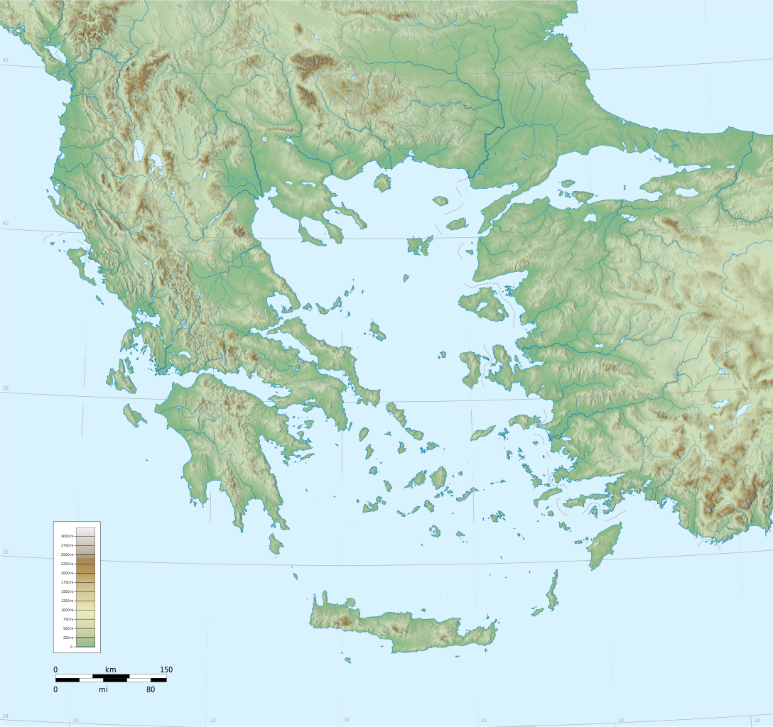
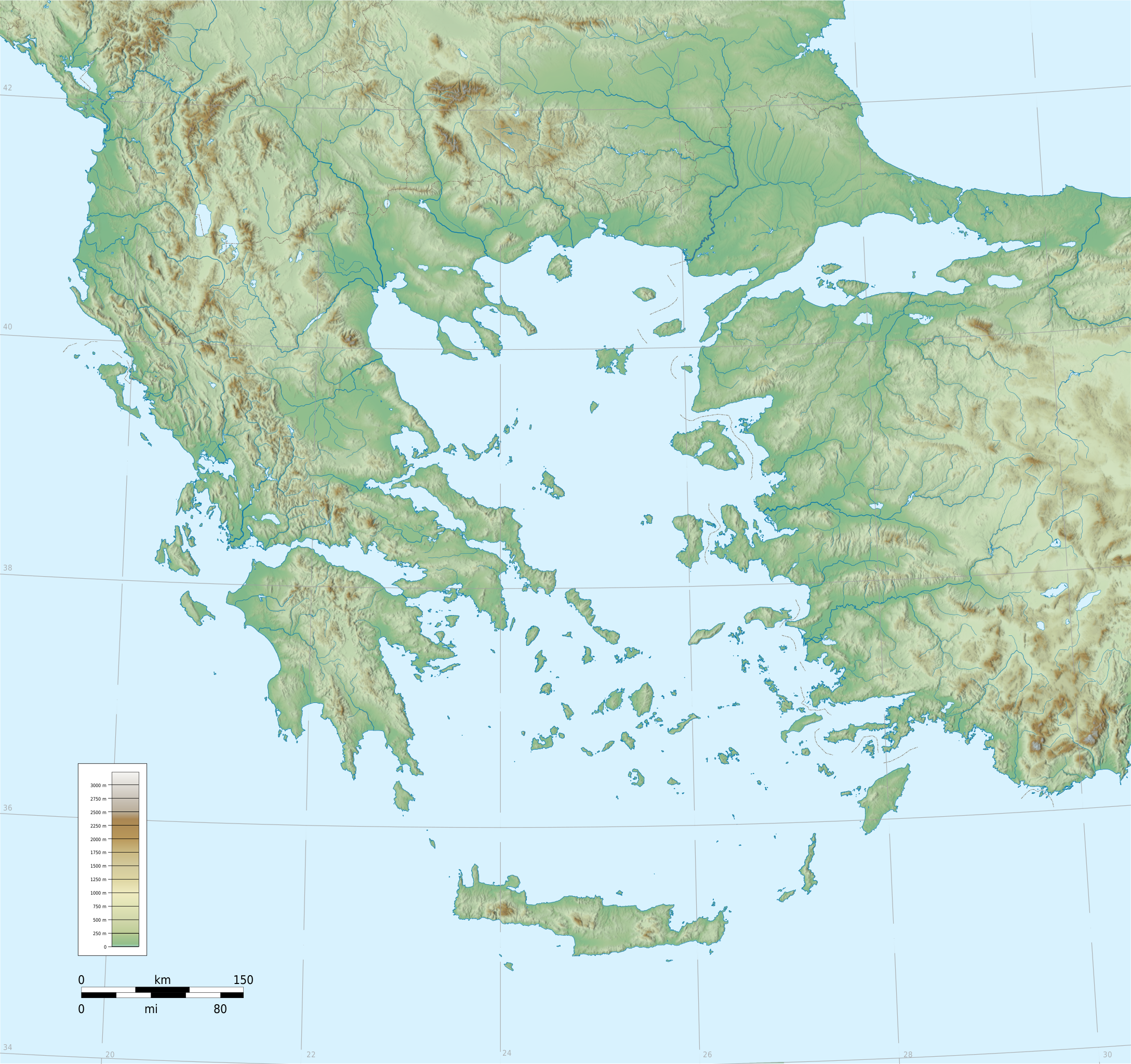
English: Southern Balkans (incl. Greece, Albania, Macedonia), Aegean and western Anatolia.
Blank topographic basemap: coastlines + water bodies as per SWBD, elevation contours from SRTM. Modern international boundaries added from VMAP0. Coverage: c.34°N 19°E – 42.4°N 31°E. Projection: Lambert Conformal Conic, Lon0=24,Lat0=38.5,Lat1=43,Lat2=34 Relief coloring and shading is an embedded bitmap; coastlines and other layers in SVG |
| Date | |
| Source | Travail personnel |
| Auteur | Fut.Perf. |
| Autres versions |
Œuvres dérivées de ce fichier :
|
| SVG information |
Conditions d’utilisation
[modifier]
| Moi, propriétaire des droits d’auteur sur cette œuvre, la place dans le domaine public. Ceci s'applique dans le monde entier. Dans certains pays, ceci peut ne pas être possible ; dans ce cas : J’accorde à toute personne le droit d’utiliser cette œuvre dans n’importe quel but, sans aucune condition, sauf celles requises par la loi. |
Historique du fichier
Cliquer sur une date et heure pour voir le fichier tel qu'il était à ce moment-là.
| Date et heure | Vignette | Dimensions | Utilisateur | Commentaire | |
|---|---|---|---|---|---|
| actuel | 6 septembre 2009 à 18:25 | | 2 095 × 1 971 (13,21 Mio) | Future Perfect at Sunrise (d | contributions) | added rivers and color scale |
| 1 septembre 2009 à 13:21 |  | 2 095 × 1 971 (12,43 Mio) | Future Perfect at Sunrise (d | contributions) | some fixes | |
| 30 août 2009 à 08:26 |  | 2 095 × 1 971 (13,29 Mio) | Future Perfect at Sunrise (d | contributions) | reduced even further, still not displaying | |
| 30 août 2009 à 07:46 |  | 2 095 × 1 971 (21,09 Mio) | Future Perfect at Sunrise (d | contributions) | try smaller embedded bitmap, since previous version wouldn't display | |
| 30 août 2009 à 05:14 |  | 2 095 × 1 971 (29,08 Mio) | Future Perfect at Sunrise (d | contributions) | {{Information |Description={{en|1=Southern Balkans (incl. Greece, Albania, Macedonia), Aegean and western Anatolia. Blank topographic basemap |
Vous ne pouvez pas remplacer ce fichier.
Utilisations locales du fichier
Les 18 pages suivantes utilisent ce fichier :
- User:Linguae
- File:Bellum mithridaticum 85aC.png
- File:Bellum mithridaticum 87-86aC.png
- File:Continent mycénien.svg
- File:Crète mycénienne.svg
- File:Greece (ancient) Attica (relief-cropped).png
- File:Greece (ancient) Central (relief-cropped).png
- File:Greece (ancient) Chalcidice (relief-cropped).png
- File:Greece (ancient) Epirus (relief-cropped).png
- File:Greece (ancient) Euboea (relief-cropped).png
- File:Greece (ancient) IonianIslands (relief-cropped).png
- File:Greece (ancient) Macedonia (relief-cropped).png
- File:Greece (ancient) NorthAegean (relief-cropped).png
- File:Greece (ancient) Peloponnesus (relief-cropped).png
- File:Greece (ancient) SouthAegean (relief-cropped).png
- File:Greece (ancient) Thessaly (relief-cropped).png
- File:Greece large topographic basemap.svg
- File:Monde égéen mycénien.svg
_Attica_(relief-cropped).png)
_Central_(relief-cropped).png)
_Chalcidice_(relief-cropped).png)
_Epirus_(relief-cropped).png)
_Euboea_(relief-cropped).png)
_IonianIslands_(relief-cropped).png)
_Macedonia_(relief-cropped).png)
_NorthAegean_(relief-cropped).png)
_Peloponnesus_(relief-cropped).png)
_SouthAegean_(relief-cropped).png)
_Thessaly_(relief-cropped).png)
Utilisations du fichier sur d’autres wikis
Les autres wikis suivants utilisent ce fichier :
- Utilisation sur en.wikipedia.org
- Utilisation sur fr.wikipedia.org
- Utilisation sur he.wikipedia.org
- Utilisation sur hyw.wikipedia.org
- Utilisation sur lv.wikipedia.org