File:Gregory House in New London.jpg
Salta a la navegació
Salta a la cerca

Mida d'aquesta previsualització: 800 × 532 píxels. Altres resolucions: 320 × 213 píxels | 640 × 426 píxels | 1.024 × 681 píxels | 1.280 × 851 píxels | 2.560 × 1.702 píxels | 6.016 × 4.000 píxels.
Fitxer original (6.016 × 4.000 píxels, mida del fitxer: 6,92 Mo, tipus MIME: image/jpeg)
Llegendes
Llegendes
Afegeix una explicació d'una línia del que representa aquest fitxer
|
This is an image of a place or building that is listed on the National Register of Historic Places in the United States of America. Its reference number is 84003746. |
| Posició de la càmera | | Aquesta i altres imatges properes a: OpenStreetMap |
|---|
| Descripció |
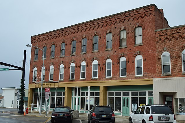
English: Front of the Gregory House, located on the northeastern corner of the junction of North (State Route 60) and East (State Route 162) Main Streets in New London, Ohio, United States. Built in 1873, it is listed on the National Register of Historic Places. |
||
| Data | Taken on 23 de desembre de 2014 | ||
| Font | Treball propi | ||
| Autor | Nyttend | ||
| Permís (Com reutilitzar aquest fitxer) |
|
Historial del fitxer
Cliqueu una data/hora per veure el fitxer tal com era aleshores.
| Data/hora | Miniatura | Dimensions | Usuari/a | Comentari | |
|---|---|---|---|---|---|
| actual | 14:19, 26 des 2014 | | 6.016 × 4.000 (6,92 Mo) | Nyttend (discussió | contribucions) | {{NRHP|84003746}} {{Location|41|5|7.5|N|82|23|57|W}} {{Information |Description={{en|Front of the {{w|Gregory House (New London, Ohio)|Gregory House}}, located on the northeastern corner of the junction of North ({{w|Ohio State Route 60|State Route 60}... |
No podeu sobreescriure aquest fitxer.
Ús del fitxer
La pàgina següent utilitza aquest fitxer:
Ús global del fitxer
Utilització d'aquest fitxer en altres wikis:
- Utilització a ar.wikipedia.org
- Utilització a ca.wikipedia.org
- Utilització a ceb.wikipedia.org
- Utilització a cy.wikipedia.org
- Utilització a en.wikipedia.org
- Utilització a es.wikipedia.org
- Utilització a eu.wikipedia.org
- Utilització a fr.wikipedia.org
- Utilització a ht.wikipedia.org
- Utilització a it.wikipedia.org
- Utilització a lld.wikipedia.org
- Utilització a pl.wikipedia.org
- Utilització a pt.wikipedia.org
- Utilització a sr.wikipedia.org
- Utilització a uk.wikipedia.org
- Utilització a ur.wikipedia.org
- Utilització a vi.wikipedia.org
- Utilització a www.wikidata.org
- Utilització a zh-min-nan.wikipedia.org