File:Grindavik area annotated.jpg
Zur Navigation springen
Zur Suche springen

Größe dieser Vorschau: 800 × 530 Pixel. Weitere Auflösungen: 320 × 212 Pixel | 640 × 424 Pixel | 1.024 × 678 Pixel | 1.280 × 848 Pixel | 2.560 × 1.696 Pixel | 4.096 × 2.713 Pixel.
Originaldatei (4.096 × 2.713 Pixel, Dateigröße: 2,32 MB, MIME-Typ: image/jpeg)
Bildtexte
Kurzbeschreibungen
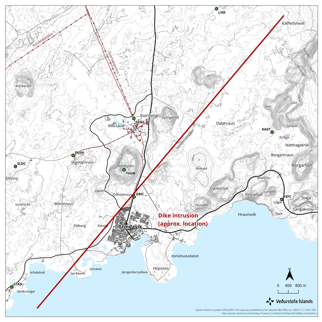
Markierte Luftaufnahme des Grindavík Gebiets mit seismischen Störungen von 2023
Beschreibung
[Bearbeiten]
| Beschreibung |
English: Annotated view of Grindavík and surrounding area involved in the 2023 seismic disturbances. Based on https://en.vedur.is/media/uncategorized/Kort-ragnar-enska-11-nov.png |
| Datum | |
| Quelle | File:Aerial_view_of_Grindavík,_Hópsnes_and_mountains.jpg |
| Urheber | Olga Ernst annotated by Prioryman |
| Kameraposition | | Dieses und weitere Bilder auf OpenStreetMap |
|---|
Lizenz
[Bearbeiten]
Ich, der Urheber dieses Werkes, veröffentliche es unter der folgenden Lizenz:
Diese Datei ist lizenziert unter der Creative-Commons-Lizenz „Namensnennung – Weitergabe unter gleichen Bedingungen 4.0 international“.
- Dieses Werk darf von dir
- verbreitet werden – vervielfältigt, verbreitet und öffentlich zugänglich gemacht werden
- neu zusammengestellt werden – abgewandelt und bearbeitet werden
- Zu den folgenden Bedingungen:
- Namensnennung – Du musst angemessene Urheber- und Rechteangaben machen, einen Link zur Lizenz beifügen und angeben, ob Änderungen vorgenommen wurden. Diese Angaben dürfen in jeder angemessenen Art und Weise gemacht werden, allerdings nicht so, dass der Eindruck entsteht, der Lizenzgeber unterstütze gerade dich oder deine Nutzung besonders.
- Weitergabe unter gleichen Bedingungen – Wenn du das Material wiedermischst, transformierst oder darauf aufbaust, musst du deine Beiträge unter der gleichen oder einer kompatiblen Lizenz wie das Original verbreiten.
| Bildnotizen | Diese Datei ist annotiert: Betrachte diese auf Commons. |
Dateiversionen
Klicke auf einen Zeitpunkt, um diese Version zu laden.
| Version vom | Vorschaubild | Maße | Benutzer | Kommentar | |
|---|---|---|---|---|---|
| aktuell | 14:38, 13. Nov. 2023 | | 4.096 × 2.713 (2,32 MB) | Prioryman (Diskussion | Beiträge) | |
| 14:33, 13. Nov. 2023 |  | 4.096 × 2.713 (2,32 MB) | Prioryman (Diskussion | Beiträge) | Uploaded a work by https://commons.wikimedia.org/wiki/User:Olga_Ernst from https://commons.wikimedia.org/wiki/File:Aerial_view_of_Grindav%C3%ADk,_H%C3%B3psnes_and_mountains.jpg with UploadWizard |
Du kannst diese Datei nicht überschreiben.
Dateiverwendung
Die folgende Seite verwendet diese Datei:
Globale Dateiverwendung
Die nachfolgenden anderen Wikis verwenden diese Datei:
- Verwendung auf cs.wikipedia.org
- Verwendung auf de.wikipedia.org
- Verwendung auf en.wikipedia.org
- Verwendung auf es.wikipedia.org
- Verwendung auf fr.wikipedia.org
- Verwendung auf hu.wikipedia.org
- Verwendung auf is.wikipedia.org
- Verwendung auf ko.wikipedia.org
- Verwendung auf nl.wikipedia.org
Kategorien:
- Hópsnes (Grindavík)
- Aerial photographs of Grindavík
- Húsafell (Grindavík)
- Sýlingafell
- Remote views of Þorbjörn
- 2022 aerial photographs of Iceland
- Aerial photographs of Þorbjörn
- Svartsengi power station
- Hagafell (Grindavík)
- Sundhnúkagígaröðin
- Igneous intrusions in Iceland in 2023
- Geology of Reykjanes (peninsula), South-west Iceland
- Igneous intrusions of the Svartsengi volcanic system
- Geological maps of Reykjanes peninsula, Iceland
- Volcano-tectonic episode in 2023 centered on the Svartsengi volcanic system
- Igneous intrusion feeding the 2023 Sundhnúkur Eruption
- Blue Lagoon in November 2023