File:Grindavik area annotated.jpg
Ir a la navegación
Ir a la búsqueda

Tamaño de esta previsualización: 800 × 530 píxeles. Otras resoluciones: 320 × 212 píxeles | 640 × 424 píxeles | 1024 × 678 píxeles | 1280 × 848 píxeles | 2560 × 1696 píxeles | 4096 × 2713 píxeles.
Archivo original (4096 × 2713 píxeles; tamaño de archivo: 2,32 MB; tipo MIME: image/jpeg)
Leyendas
Leyendas
Añade una explicación corta acerca de lo que representa este archivo
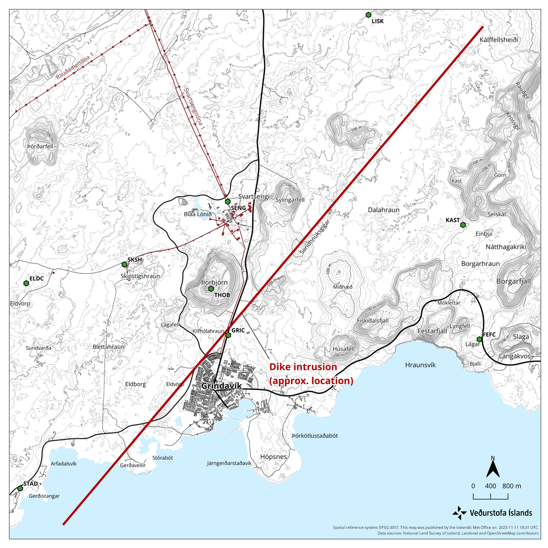
Annotated aerial view of Grindavik area with 2023 seismic disturbances
Resumen[editar]
| Descripción |
English: Annotated view of Grindavík and surrounding area involved in the 2023 seismic disturbances. Based on https://en.vedur.is/media/uncategorized/Kort-ragnar-enska-11-nov.png |
| Fecha | |
| Fuente | File:Aerial_view_of_Grindavík,_Hópsnes_and_mountains.jpg |
| Autor | Olga Ernst annotated by Prioryman |
| Posición de la cámara | | Ubicación de esta y otras imágenes en: OpenStreetMap |
|---|
Licencia[editar]
Yo, el titular de los derechos de autor de esta obra, la publico en los términos de la siguiente licencia:
Este archivo está disponible bajo la licencia Creative Commons Attribution-Share Alike 4.0 International.
- Eres libre:
- de compartir – de copiar, distribuir y transmitir el trabajo
- de remezclar – de adaptar el trabajo
- Bajo las siguientes condiciones:
- atribución – Debes otorgar el crédito correspondiente, proporcionar un enlace a la licencia e indicar si realizaste algún cambio. Puedes hacerlo de cualquier manera razonable pero no de manera que sugiera que el licenciante te respalda a ti o al uso que hagas del trabajo.
- compartir igual – En caso de mezclar, transformar o modificar este trabajo, deberás distribuir el trabajo resultante bajo la misma licencia o una compatible como el original.
| Annotations | This image is annotated: View the annotations at Commons |
Historial del archivo
Haz clic sobre una fecha y hora para ver el archivo tal como apareció en ese momento.
| Fecha y hora | Miniatura | Dimensiones | Usuario | Comentario | |
|---|---|---|---|---|---|
| actual | 14:38 13 nov 2023 | | 4096 × 2713 (2,32 MB) | Prioryman (discusión | contribs.) | |
| 14:33 13 nov 2023 |  | 4096 × 2713 (2,32 MB) | Prioryman (discusión | contribs.) | Uploaded a work by https://commons.wikimedia.org/wiki/User:Olga_Ernst from https://commons.wikimedia.org/wiki/File:Aerial_view_of_Grindav%C3%ADk,_H%C3%B3psnes_and_mountains.jpg with UploadWizard |
No puedes sobrescribir este archivo.
Usos del archivo
La siguiente página usa este archivo:
Uso global del archivo
Las wikis siguientes utilizan este archivo:
- Uso en cs.wikipedia.org
- Uso en de.wikipedia.org
- Uso en en.wikipedia.org
- Uso en es.wikipedia.org
- Uso en fr.wikipedia.org
- Uso en hu.wikipedia.org
- Uso en is.wikipedia.org
- Uso en ko.wikipedia.org
- Uso en nl.wikipedia.org
Categorías:
- Hópsnes (Grindavík)
- Aerial photographs of Grindavík
- Húsafell (Grindavík)
- Sýlingafell
- Remote views of Þorbjörn
- 2022 aerial photographs of Iceland
- Aerial photographs of Þorbjörn
- Svartsengi power station
- Hagafell (Grindavík)
- Sundhnúkagígaröðin
- Igneous intrusions in Iceland in 2023
- Geology of Reykjanes (peninsula), South-west Iceland
- Igneous intrusions of the Svartsengi volcanic system
- Geological maps of Reykjanes peninsula, Iceland
- Volcano-tectonic episode in 2023 centered on the Svartsengi volcanic system
- Igneous intrusion feeding the 2023 Sundhnúkur Eruption
- Blue Lagoon in November 2023