File:Grossglockner from SW.jpg
跳至導覽
跳至搜尋

預覽大小:800 × 600 像素。 其他解析度:320 × 240 像素 | 640 × 480 像素 | 1,024 × 768 像素 | 1,280 × 960 像素 | 1,884 × 1,413 像素。
原始檔案 (1,884 × 1,413 像素,檔案大小:421 KB,MIME 類型:image/jpeg)
說明
說明
添加單行說明來描述出檔案所代表的內容
摘要
[編輯]| 描述 |
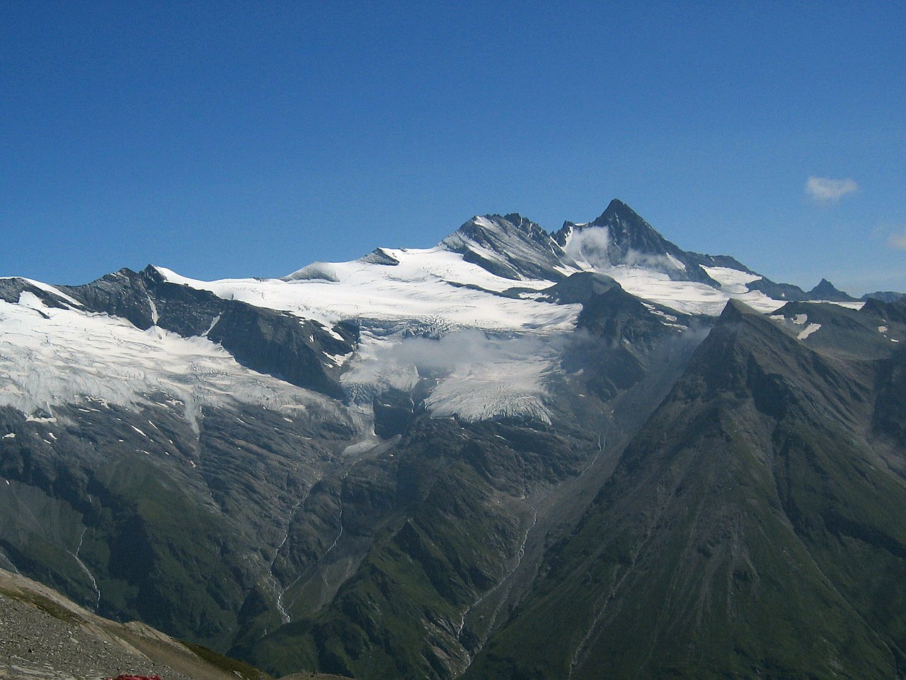
Deutsch: Großglockner vom Südwesten. Der Großglockner (3.797 m) ist der höchste pyramidenförmig erscheinende Gipfel rechts von der Mitte. Der breite großteils schneefreie Berg links davon ist die Glocknerwand (3.722 m) und ihr linker Eckpfeiler Hofmannspitze. Links im Bild ist über einer Felswand (Romariswand) der Romariswandkopf (3.511 m) zu sehen. Der pyramidenförmige Berg im Vordergrund, vor dem Großglockner, ist die Zollspitze (3.024 m).
Der Gletscher vor dem Großglockner ist das Teischnitzkees; rechts oberhalb der Romariswand ist das Fruschnitzkees. Aufnahmeort: Am Silesia Höhenweg, nahe dem Sattel nördlich des Gradötzkogel aufgenommen, in ca. 2.800 m Höhe und in 8 km Entfernung vom Gipfel des Großglockners.English: Großglockner seen from the southwest. The Großglockner (3.797 m), the highest peak of Austria, is the highest peak in the image, pyramid-shaped, right of the center. Left of it, the more elongated and mostly snow-free mountain is the Glocknerwand (3.722 m) with its left pillar Hofmannspitze. The Romariswandkopf (3.511 m) is the peak of the rock wall (Romariswand) in the left part of the image. The pyramid-shaped peak in front of the Großglockner is the Zollspitze (3.024 m). The glacier in front of the Großglockner is the Teischnitzkees, that behind and right of the Romariswand is the Fruschnitzkees. Français : Le Grossglockner vu du sud-ouest. Le Grossglockner (3797 m), est le plus haut sommet d'Autriche. La montage plus allongée et presque libre de neige à sa gauche porte le Glocknerwand (3722 m) et le Hofmannspitze. Tout à gauche, le Romariswandkopf ("Pic du mur de pierre", 3511 m) est visible. Le sommet en forme de pyramide devant le Grossglockner s'appelle Zollspitze (3024 m). Le glacier visible devant le Grossglockner est le Teischnitzkees, celui se trouvant en arrière et à droite du Romariswand, le Fruschnitzkees. |
| 日期 | |
| 來源 | Photo taken by myself, cropped, color balance slightly adjusted. |
| 作者 | Michael Schmid |
| 其他版本 |

授權條款
[編輯]
我,本作品的著作權持有者,決定用以下授權條款發佈本作品:
此檔案採用創用CC 姓名標示-相同方式分享 2.0 奧地利授權條款。
- 您可以自由:
- 分享 – 複製、發佈和傳播本作品
- 重新修改 – 創作演繹作品
- 惟需遵照下列條件:
- 姓名標示 – 您必須指名出正確的製作者,和提供授權條款的連結,以及表示是否有對內容上做出變更。您可以用任何合理的方式來行動,但不得以任何方式表明授權條款是對您許可或是由您所使用。
- 相同方式分享 – 如果您利用本素材進行再混合、轉換或創作,您必須基於如同原先的相同或兼容的條款,來分布您的貢獻成品。

|
|
檔案歷史
點選日期/時間以檢視該時間的檔案版本。
| 日期/時間 | 縮圖 | 尺寸 | 用戶 | 備註 | |
|---|---|---|---|---|---|
| 目前 | 2005年7月10日 (日) 18:04 | | 1,884 × 1,413(421 KB) | Schmid(對話 | 貢獻) | {{Information |Description = Großglockner seen from the southwest | Source = Photo taken by myself, cropped, color balance slightly adjusted. | Date = 2003-Jul-30 | Author = Michael Schmid | Permission = Michael Schmid put |
無法覆蓋此檔案。
檔案用途
下列11個頁面有用到此檔案:
- Großglockner
- Heiligenblut
- Highest
- Kärnten - Koróška
- Mountains of Austria
- Österreich
- User talk:Anna reg/Archive
- User talk:Schmid
- Commons:Quality images/Subject/Places/Natural structures/archive 2008 to 2012
- Commons:Quality images candidates/Archives June 2008
- File:Romariswand, -kopf & Grossglockner from SW.jpg
全域檔案使用狀況
以下其他 wiki 使用了這個檔案:
- an.wikipedia.org 的使用狀況
- ar.wikipedia.org 的使用狀況
- bg.wikipedia.org 的使用狀況
- bn.wikipedia.org 的使用狀況
- bn.wikibooks.org 的使用狀況
- bs.wikipedia.org 的使用狀況
- ca.wikipedia.org 的使用狀況
- cs.wikipedia.org 的使用狀況
- Rakousko
- Großglockner
- Karavanky
- Totes Gebirge
- Ennstalské Alpy
- Vysoké Taury
- Nízké Taury
- Hory Solné komory
- Dachstein
- Rakouské Alpy
- Zillertalské Alpy
- Ötztalské Alpy
- Stubaiské Alpy
- Gailtalské Alpy
- Steinberge
- Hochschwab
- Rax
- Berchtesgadenské Alpy
- Vídeňský les
- Gutensteinské Alpy
- Türnitzské Alpy
- Mürzstegské Alpy
- Ybbstalské Alpy
- Hornorakouské předhůří
- Tennengebirge
- Dientener Berge
- Kaisergebirge
- Chiemgauské Alpy
- Rofan
- Karwendel
- Nockberge
- Wetterstein
- Lechtalské Alpy
- Verwall
- Lechquellengebirge
- Bregenzský les (pohoří)
- Algavské Alpy
- Lavanttalské Alpy
- Villgratenské hory
- Kitzbühelské Alpy
- Tuxské Alpy
- Silvretta
檢視此檔案的更多全域使用狀況。