File:Gulf of Taranto map.png
跳转到导航
跳转到搜索

本预览的尺寸:545 × 600像素。 其他分辨率:218 × 240像素 | 436 × 480像素 | 698 × 768像素 | 1,200 × 1,321像素。
原始文件 (1,200 × 1,321像素,文件大小:348 KB,MIME类型:image/png)
说明
说明
添加一行文字以描述该文件所表现的内容
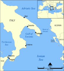
Map of the Gulf of Taranto
A map showing the location of the Gulf of Taranto in the Mediterranean sea, south of Italy.
Created by NormanEinstein, March 28, 2006.
我,本作品著作权人,特此采用以下许可协议发表本作品:

|
已授权您依据自由软件基金会发行的无固定段落及封面封底文字(Invariant Sections, Front-Cover Texts, and Back-Cover Texts)的GNU自由文件许可协议1.2版或任意后续版本的条款,复制、传播和/或修改本文件。该协议的副本请见“GNU Free Documentation License”。 |
| 本文件采用知识共享署名-相同方式共享 3.0 未本地化版本许可协议授权。 | ||
| ||
| 本许可协议标签作为GFDL许可协议更新的组成部分被添加至本文件。 |
Other versions
[编辑]
- Croatian: File:Gulf of Taranto map hr.svg
文件历史
点击某个日期/时间查看对应时刻的文件。
| 日期/时间 | 缩略图 | 大小 | 用户 | 备注 | |
|---|---|---|---|---|---|
| 当前 | 2009年6月3日 (三) 14:35 | | 1,200 × 1,321(348 KB) | Rhegion(留言 | 贡献) | added Reggio |
| 2006年3月28日 (二) 18:53 |  | 1,200 × 1,321(409 KB) | NormanEinstein(留言 | 贡献) | A map showing the location of the Gulf of Taranto in the Mediterranean sea, south of Italy. Created by NormanEinstein, March 28, 2006. {{GFDL-self}} |
您不可以覆盖此文件。
文件用途
以下2个页面使用本文件:
全域文件用途
以下其他wiki使用此文件:
- ar.wikipedia.org上的用途
- az.wikipedia.org上的用途
- ba.wikipedia.org上的用途
- be-tarask.wikipedia.org上的用途
- be.wikipedia.org上的用途
- br.wikipedia.org上的用途
- bs.wikipedia.org上的用途
- ckb.wikipedia.org上的用途
- cs.wikipedia.org上的用途
- da.wikipedia.org上的用途
- de.wikipedia.org上的用途
- de.wikibooks.org上的用途
- el.wikipedia.org上的用途
- en.wikipedia.org上的用途
- Tegetthoff-class battleship
- SMS Szent István
- Gulf of Taranto
- SMS Prinz Eugen (1912)
- User:NormanEinstein/gallery
- Adriatic campaign of 1807–1814
- Wikipedia:Graphics Lab/Map workshop/Archive/Feb 2012
- SMS Saida
- Yugoslav torpedo boat T4
- Novara-class cruiser
- SMS Tegetthoff (1912)
- SMS Admiral Spaun
- SMS Orjen
- eo.wikipedia.org上的用途
- es.wikipedia.org上的用途
- eu.wikipedia.org上的用途
- ext.wikipedia.org上的用途
- fa.wikipedia.org上的用途
- fi.wikipedia.org上的用途
- fo.wikipedia.org上的用途
- frr.wikipedia.org上的用途
- fr.wikipedia.org上的用途
查看此文件的更多全域用途。