File:Gulf of Tonkin location.gif
跳至導覽
跳至搜尋
無更高解析度可提供。
Gulf_of_Tonkin_location.gif (500 × 500 像素,檔案大小:90 KB,MIME 類型:image/gif)
說明
說明
添加單行說明來描述出檔案所代表的內容

|
本圖片是以PNG、GIF或JPEG格式上傳。然而,其中包含的資料或訊息,應該重新建立成可縮放向量圖形(SVG)檔案,以更有效率或更準確的方式儲存。如有可能,請上傳本圖片的SVG格式版本。在上傳之後,請修改維基各姊妹計畫中所有使用舊版圖片的條目(列在圖像連結章節中),替換為新版圖片,並在舊圖片的描述頁中加入{{Vector version available|新圖片名稱.svg}}模板,同時移除本模板。
|
| 描述 |
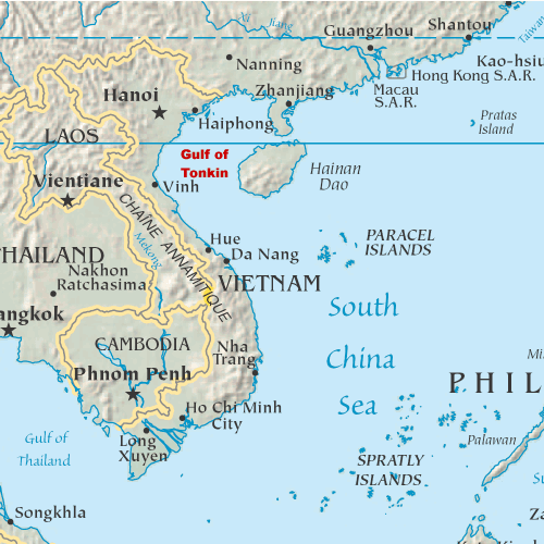
English: Map showing the location of the Gulf of Tonkin in the South China Sea |
||
| 日期 | 2005年10月31日 (原始上傳日期) | ||
| 來源 | My original artwork based on a public domain map from the CIA World Factbook. | ||
| 作者 | 原上傳者為英文維基百科的DanMS | ||
| 授權許可 (重用此檔案) |
|
原始上傳日誌
[編輯]
The original description page was here. All following user names refer to en.wikipedia.
- 2005-11-02 16:39 DanMS 500×500× (92188 bytes) Map showing the location of the Gulf of Tonkin in the South China Sea. My original artwork based on a public domain map from the CIA World Factbook. This is a modification of my earlier file by the same name. {{pd-user|DanMS}}
- 2005-10-31 21:55 DanMS 500×500× (89358 bytes) Map showing the location of the Gulf of Tonkin in the South China Sea. My original artwork based on a public domain map from the CIA World Factbook. {{pd-user|DanMS}}
檔案歷史
點選日期/時間以檢視該時間的檔案版本。
| 日期/時間 | 縮圖 | 尺寸 | 使用者 | 備註 | |
|---|---|---|---|---|---|
| 目前 | 2010年5月15日 (六) 11:29 | | 500 × 500(90 KB) | Urdangaray(留言 | 貢獻) | {{Information |Description={{en|Map showing the location of the Gulf of Tonkin in the South China Sea. My original artwork based on a public domain map from the CIA World Factbook.}} |Source=Transferred from [http://en.wikipedia.org en.wikipedia] |Date={{ |
無法覆蓋此檔案。
檔案用途
下列頁面有用到此檔案:
全域檔案使用狀況
以下其他 wiki 使用了這個檔案:
- af.wikipedia.org 的使用狀況
- ar.wikipedia.org 的使用狀況
- bg.wikipedia.org 的使用狀況
- bn.wikipedia.org 的使用狀況
- bs.wikipedia.org 的使用狀況
- cs.wikipedia.org 的使用狀況
- cy.wikipedia.org 的使用狀況
- de.wikipedia.org 的使用狀況
- en.wikipedia.org 的使用狀況
- es.wikipedia.org 的使用狀況
- fa.wikipedia.org 的使用狀況
- fi.wikipedia.org 的使用狀況
- fr.wikipedia.org 的使用狀況
- fy.wikipedia.org 的使用狀況
- he.wikipedia.org 的使用狀況
- hi.wikipedia.org 的使用狀況
- hu.wikipedia.org 的使用狀況
- id.wikipedia.org 的使用狀況
- ilo.wikipedia.org 的使用狀況
- it.wikipedia.org 的使用狀況
- ja.wikipedia.org 的使用狀況
- km.wikipedia.org 的使用狀況
- ky.wikipedia.org 的使用狀況
- mk.wikipedia.org 的使用狀況
- nds-nl.wikipedia.org 的使用狀況
- nl.wikipedia.org 的使用狀況
- nn.wikipedia.org 的使用狀況
- pl.wikipedia.org 的使用狀況
- sh.wikipedia.org 的使用狀況
- sl.wikipedia.org 的使用狀況
- sr.wikipedia.org 的使用狀況
- th.wikipedia.org 的使用狀況
- ur.wikipedia.org 的使用狀況
- vi.wikipedia.org 的使用狀況
- war.wikipedia.org 的使用狀況
- zh.wikipedia.org 的使用狀況