File:Haishen 2015 track.png
ナビゲーションに移動
検索に移動

このプレビューのサイズ: 800 × 495 ピクセル。 その他の解像度: 320 × 198 ピクセル | 640 × 396 ピクセル | 1,024 × 633 ピクセル | 1,280 × 791 ピクセル | 2,700 × 1,669 ピクセル。
元のファイル (2,700 × 1,669 ピクセル、ファイルサイズ: 460キロバイト、MIME タイプ: image/png)
キャプション
キャプション
このファイルの内容を1行で記述してください
概要
| 解説 |
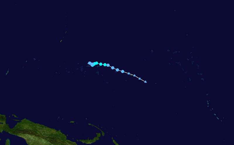
English: Track map of Tropical Storm Haishen of the 2015 Pacific typhoon season. The points show the location of the storm at 6-hour intervals. The colour represents the storm's maximum sustained wind speeds as classified in the (see below), and the shape of the data points represent the nature of the storm, according to the legend below. Tropical depression (≤38 mph, ≤62 km/h)
Tropical storm (39–73 mph, 63–118 km/h)
Category 1 (74–95 mph, 119–153 km/h)
Category 2 (96–110 mph, 154–177 km/h)
Category 3 (111–129 mph, 178–208 km/h)
Category 4 (130–156 mph, 209–251 km/h)
Category 5 (≥157 mph, ≥252 km/h)
Unknown
Storm type |
||
| 日付 | 2015-04-02–2015-04-06 | ||
| 原典 | Created by Keith Edkins using Wikipedia:WikiProject Tropical cyclones/Tracks. The background image is from NASA. Tracking data is from the Joint Typhoon Warning Center[1]. | ||
| 作者 | Keith Edkins | ||
| Source code | Track map data table, if present below, is in HURDAT2 or ATCF format. See format details in [2] and [3], respectively.
|
ライセンス[編集]
| この著作物は、著作者であるKeith Edkinsによって権利が放棄され、パブリックドメインとされました。これは全世界で適用されます。 一部の国では、これが法的に可能ではない場合があります。その場合は、次のように宣言します。 Keith Edkinsは、あらゆる人に対して、法により必要とされている条件を除き、如何なる条件も課すことなく、あらゆる目的のためにこの著作物を使用する権利を与えます。 |
ファイルの履歴
過去の版のファイルを表示するには、その版の日時をクリックしてください。
| 日付と時刻 | サムネイル | 寸法 | 利用者 | コメント | |
|---|---|---|---|---|---|
| 現在の版 | 2020年2月24日 (月) 01:01 | | 2,700 × 1,669 (460キロバイト) | Supportstorm (トーク | 投稿記録) | JTWC data |
| 2016年9月27日 (火) 20:27 |  | 2,700 × 1,669 (459キロバイト) | Supportstorm (トーク | 投稿記録) | IBTrACS version | |
| 2016年6月18日 (土) 06:27 |  | 2,700 × 1,669 (460キロバイト) | Supportstorm (トーク | 投稿記録) | JTWC BT integration | |
| 2015年4月8日 (水) 07:03 |  | 1,024 × 633 (125キロバイト) | Keith Edkins (トーク | 投稿記録) | Final operational update | |
| 2015年4月7日 (火) 07:06 |  | 1,024 × 633 (123キロバイト) | Keith Edkins (トーク | 投稿記録) | Updated 06/1800z | |
| 2015年4月6日 (月) 07:15 |  | 3,000 × 1,854 (566キロバイト) | Krit-tonkla (トーク | 投稿記録) | 06 Apr 00Z | |
| 2015年4月5日 (日) 14:17 |  | 3,000 × 1,854 (570キロバイト) | Krit-tonkla (トーク | 投稿記録) | 5 Apr 12Z | |
| 2015年4月5日 (日) 07:57 |  | 1,024 × 633 (123キロバイト) | Keith Edkins (トーク | 投稿記録) | Updated 05/0000z | |
| 2015年4月4日 (土) 07:02 |  | 1,024 × 633 (120キロバイト) | Keith Edkins (トーク | 投稿記録) | Updated 03/1800z | |
| 2015年4月3日 (金) 07:51 |  | 1,024 × 633 (120キロバイト) | Keith Edkins (トーク | 投稿記録) | {{Information |Description={{en|Track map of Tropical Depression 05W of the 2015 Pacific typhoon season. The points show the location of the storm at 6-hour int... |
このファイルは上書きできません。
ファイルの使用状況
以下のページがこのファイルを使用しています:
- File:05W 2015 track.png (リダイレクト)
グローバルなファイル使用状況
以下に挙げる他のウィキがこの画像を使っています:
- de.wikipedia.org での使用状況
- en.wikipedia.org での使用状況
- es.wikipedia.org での使用状況
- fr.wikipedia.org での使用状況
- ja.wikipedia.org での使用状況
- ko.wikipedia.org での使用状況
- pt.wikipedia.org での使用状況
- th.wikipedia.org での使用状況
- vi.wikipedia.org での使用状況
- zh-yue.wikipedia.org での使用状況
- zh.wikipedia.org での使用状況