File:Happisburgh coastal erosion.jpg

Originaldatei (1.024 × 683 Pixel, Dateigröße: 118 KB, MIME-Typ: image/jpeg)
Bildtexte
Kurzbeschreibungen
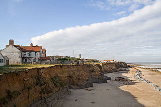
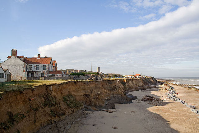
Coastal erosion of sea cliffs at Happisburgh, Norfolk UK.
Looking north west from the end of Beach Road, Happisburgh. The soft sedimentary rock of the cliffs is seeing some of the fastest coastal erosion in Norfolk. Several houses on Beach Road have already been lost to the sea and many of those remaining are in a precarious position. Some of the 1950s sea defenses, built to protect the village from further erosion, can be seen along the beach.
The tower of the 15th century St.Mary's Church can be seen in the background.
Keywords: Happisburgh, Coastal erosion, cliffs, landslide, seaside
| Photograph © Andrew Dunn, 04 November 2006. |
| Website: http://www.andrewdunnphoto.com/ |
Ich, der Urheber dieses Werkes, veröffentliche es unter der folgenden Lizenz: Diese Datei ist unter der Creative-Commons-Lizenz „Namensnennung – Weitergabe unter gleichen Bedingungen 2.0 generisch“ (US-amerikanisch) lizenziert.
|
Dateiversionen
Klicke auf einen Zeitpunkt, um diese Version zu laden.
| Version vom | Vorschaubild | Maße | Benutzer | Kommentar | |
|---|---|---|---|---|---|
| aktuell | 17:51, 5. Nov. 2006 | | 1.024 × 683 (118 KB) | Solipsist~commonswiki (Diskussion | Beiträge) | Coastal erosion of sea cliffs at Happisburgh, Norfolk UK. Looking north west from the end of Beach Road, Happisburgh. The soft sedimentary rock of the cliffs is seeing some of the fastest coastal erosion in |
Du kannst diese Datei nicht überschreiben.
Dateiverwendung
Die folgenden 30 Seiten verwenden diese Datei:
- File:The Wash England.svg
- Category:Alumni by school in Norfolk, England
- Category:Archaeological sites in Norfolk, England
- Category:Births in Norfolk, England
- Category:Bridges in Norfolk, England
- Category:Canals in Norfolk, England
- Category:Cemeteries in Norfolk, England
- Category:Deaths in Norfolk, England
- Category:Disused railway stations in Norfolk
- Category:Hospitals in Norfolk, England
- Category:Lighthouses in Norfolk, England
- Category:Maps of Norfolk, England
- Category:Meadows in Norfolk, England
- Category:Norfolk, England
- Category:Norfolk, England in the 19th century
- Category:Norfolk, England in the 2010s
- Category:Norfolk, England in the 2020s
- Category:Norfolk, England in the 20th century
- Category:Norfolk, England in the 21st century
- Category:Populated places in Norfolk, England
- Category:Rail transport in Norfolk
- Category:Railway bridges in Norfolk, England
- Category:Railway stations in Norfolk
- Category:Rivers of Norfolk, England
- Category:Roads in Norfolk, England
- Category:Towns in Norfolk, England
- Category:Views of Norfolk, England
- Category:Villages in Norfolk, England
- Category:Visitor attractions in Norfolk, England
- Category:Windmills in Norfolk
Globale Dateiverwendung
Die nachfolgenden anderen Wikis verwenden diese Datei:
- Verwendung auf ar.wikipedia.org
- Verwendung auf ast.wikipedia.org
- Verwendung auf az.wikipedia.org
- Verwendung auf be.wikipedia.org
- Verwendung auf ca.wikipedia.org
- Verwendung auf ceb.wikipedia.org
- Verwendung auf cy.wikipedia.org
- Verwendung auf de.wikipedia.org
- Verwendung auf de.wikivoyage.org
- Verwendung auf en.wikipedia.org
- Verwendung auf eo.wikipedia.org
- Verwendung auf ga.wikipedia.org
- Verwendung auf gl.wikipedia.org
- Verwendung auf he.wikipedia.org
- Verwendung auf hu.wikipedia.org
- Verwendung auf ia.wikipedia.org
- Verwendung auf it.wikipedia.org
- Verwendung auf ku.wikipedia.org
- Verwendung auf lld.wikipedia.org
- Verwendung auf os.wikipedia.org
- Verwendung auf pt.wikipedia.org
- Verwendung auf qu.wikipedia.org
- Verwendung auf ro.wikipedia.org
- Verwendung auf ru.wikipedia.org
- Verwendung auf sr.wikipedia.org
- Verwendung auf tg.wikipedia.org
- Verwendung auf tr.wikipedia.org
- Verwendung auf www.wikidata.org
- Verwendung auf zh-yue.wikipedia.org