File:Hauptmarkt Trier.jpg
跳至導覽
跳至搜尋

預覽大小:799 × 313 像素。 其他解析度:320 × 125 像素 | 640 × 251 像素 | 1,024 × 401 像素 | 1,280 × 501 像素 | 2,560 × 1,003 像素 | 9,825 × 3,849 像素。
原始檔案 (9,825 × 3,849 像素,檔案大小:10.64 MB,MIME 類型:image/jpeg)
說明
說明
添加單行說明來描述出檔案所代表的內容
摘要
[編輯]
| 描述 |
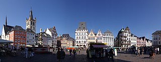
Deutsch: Denkmalzone Marktbezirk: umfasst den Bereich der mittelalterlichen Siedlung am Hauptmarkt: Umbauung des Hauptmarktes und der einmündenden Straßen und des Stockplatzes einschließlich der Markt- und Pfarrkirche St. Gangolph; dreieckiger Grundriss, im 10. Jahrhundert durch Erzbischof Heinrich I. angelegt, planmäßige Baufluchtänderungen vom späten 18. bis zum frühen 20 Jahrhundert, heutige Bebauung romanisch bis 20. Jahrhundert |
| 日期 | 攝於2009年8月15日 |
| 來源 | 自己的作品 |
| 作者 | Berthold Werner |
| 授權許可 (重用此檔案) |
GFDL |
| 其他版本 | http://www.bildindex.de/document/obj20564035?part=0&medium=fmc913134 |
| 拍攝地點 | | 位於此地的本圖片與其他圖片: OpenStreetMap |
|---|
授權條款
[編輯]
我,本作品的著作權持有者,決定用以下授權條款發佈本作品:

|
已授權您依據自由軟體基金會發行的無固定段落、封面文字和封底文字GNU自由文件授權條款1.2版或任意後續版本,對本檔進行複製、傳播和/或修改。該協議的副本列在GNU自由文件授權條款中。 |
| 此檔案採用創用CC 姓名標示-相同方式分享 3.0 未在地化版本授權條款。 | ||
| ||
| 已新增授權條款標題至此檔案,作為GFDL授權更新的一部份。 |
您可以選擇您需要的授權條款。
| 註解 | 該圖片含有註解:在維基媒體共享資源上查看註解 |
檔案歷史
點選日期/時間以檢視該時間的檔案版本。
| 日期/時間 | 縮圖 | 尺寸 | 使用者 | 備註 | |
|---|---|---|---|---|---|
| 目前 | 2009年8月16日 (日) 15:45 | 9,825 × 3,849(10.64 MB) | Berthold Werner(留言 | 貢獻) | Neu fotografiert | |
| 2006年9月7日 (四) 11:10 | 3,510 × 1,107(847 KB) | Berthold Werner(留言 | 貢獻) | {{Information |Description=Hauptmarkt in Trier |Source=own work |Date=2006-09-06 |Author=Berthold Werner |Permission=GFDL |other_versions= }} |
無法覆蓋此檔案。
檔案用途
下列5個頁面有用到此檔案:
全域檔案使用狀況
以下其他 wiki 使用了這個檔案:
- am.wikipedia.org 的使用狀況
- de.wikipedia.org 的使用狀況
- de.wikivoyage.org 的使用狀況
- en.wikipedia.org 的使用狀況
- fa.wikipedia.org 的使用狀況
- gl.wikipedia.org 的使用狀況
- hr.wikipedia.org 的使用狀況
- hu.wikipedia.org 的使用狀況
- id.wikipedia.org 的使用狀況
- ka.wikipedia.org 的使用狀況
- pnb.wikipedia.org 的使用狀況
- pt.wikipedia.org 的使用狀況
- sco.wikipedia.org 的使用狀況
- sh.wikipedia.org 的使用狀況
- sr.wikipedia.org 的使用狀況
- uk.wikipedia.org 的使用狀況
- www.wikidata.org 的使用狀況
- zh.wikipedia.org 的使用狀況