File:Hellas basin topo.jpg
跳至導覽
跳至搜尋

預覽大小:600 × 600 像素。 其他解析度:240 × 240 像素 | 480 × 480 像素 | 1,000 × 1,000 像素。
原始檔案 (1,000 × 1,000 像素,檔案大小:971 KB,MIME 類型:image/jpeg)
說明
說明
添加單行說明來描述出檔案所代表的內容


檔案歷史
點選日期/時間以檢視該時間的檔案版本。
| 日期/時間 | 縮圖 | 尺寸 | 用戶 | 備註 | |
|---|---|---|---|---|---|
| 目前 | 2009年6月26日 (五) 15:37 | | 1,000 × 1,000(971 KB) | Power(對話 | 貢獻) | better layout + scale |
| 2006年10月9日 (一) 17:29 |  | 1,024 × 1,068(842 KB) | Power(對話 | 貢獻) | ||
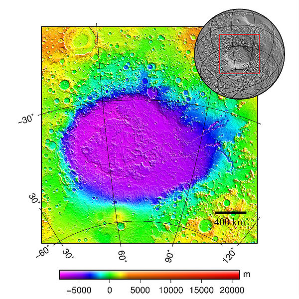
| 2006年10月5日 (四) 23:13 |  | 1,024 × 1,062(1.06 MB) | Power(對話 | 貢獻) | {{Information |Description=Hellas basin (Mars) topography |Source=plotted using GMT and gridded MOLA data archive meg0031t.grd |Date=5.10.2006 |Author=Martin Pauer (Power) |Permission=PD }} |
無法覆蓋此檔案。
檔案用途
下列2個頁面有用到此檔案:
全域檔案使用狀況
以下其他 wiki 使用了這個檔案:
- ca.wikipedia.org 的使用狀況
- cs.wikipedia.org 的使用狀況
- en.wikipedia.org 的使用狀況
- eo.wikipedia.org 的使用狀況
- es.wikipedia.org 的使用狀況
- fr.wikipedia.org 的使用狀況
- gl.wikipedia.org 的使用狀況
- it.wikipedia.org 的使用狀況
- ml.wikipedia.org 的使用狀況
- pl.wiktionary.org 的使用狀況
- pnb.wikipedia.org 的使用狀況
- pt.wikipedia.org 的使用狀況
- ro.wikipedia.org 的使用狀況
- ru.wikipedia.org 的使用狀況
- uk.wikipedia.org 的使用狀況
- ur.wikipedia.org 的使用狀況
- vi.wikipedia.org 的使用狀況
- www.wikidata.org 的使用狀況
- zh.wikipedia.org 的使用狀況