File:High Speed Railroad Map of the United States 2013.svg
ナビゲーションに移動
検索に移動

この SVG ファイルのこの PNG プレビューのサイズ: 800 × 489 ピクセル. その他の解像度: 320 × 196 ピクセル | 640 × 391 ピクセル | 1,024 × 626 ピクセル | 1,280 × 782 ピクセル | 2,560 × 1,565 ピクセル | 975 × 596 ピクセル。
元のファイル (SVG ファイル、975 × 596 ピクセル、ファイルサイズ: 232キロバイト)
キャプション
キャプション
このファイルの内容を1行で記述してください
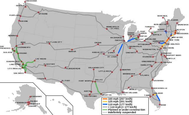
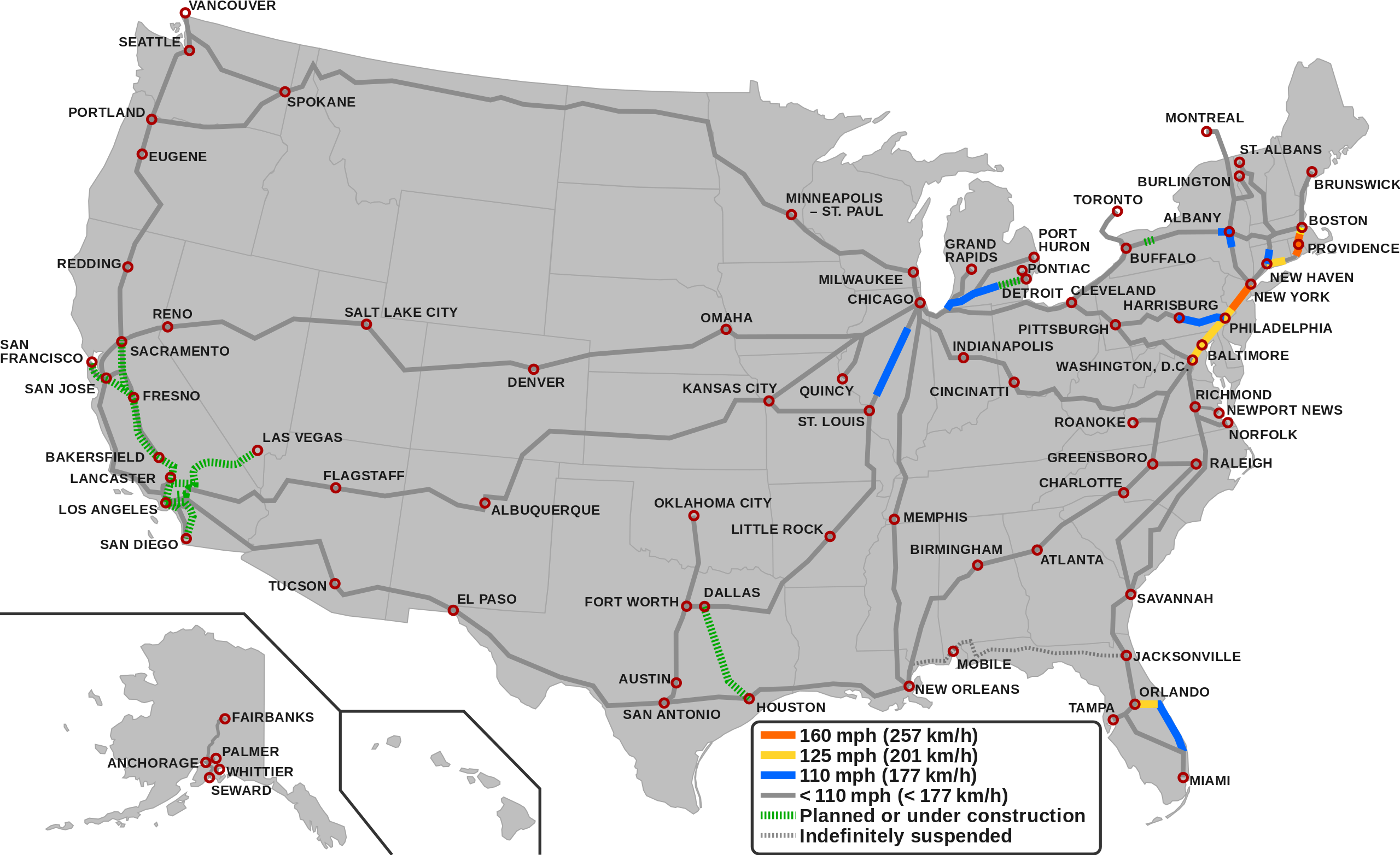
Map of the high-speed railroad lines in the USA as of 2023
概要
[編集]

|
このファイルは、最新の情報を受けて更新される可能性があります。 新しい更新が反映されることなく、特定の版のファイルを使用したい場合は、必要な版を別のファイルとしてアップロードしてください。 |
| 解説 |
English (en): Map showing the high-speed rail network of the United States.1
160 mph (257 km/h) 125 mph (201 km/h) 110 mph (177 km/h) < 110 mph (< 177 Km/h) Planned/Under construction Indefinitely suspended
1 The map depicts the actual operational high-speed instead of the designed one which may be higher.
|
| 日付 | |
| 原典 |
|
| 作者 |
|
ライセンス
[編集]
このファイルはクリエイティブ・コモンズ 表示-継承 3.0 非移植ライセンスのもとに利用を許諾されています。
- あなたは以下の条件に従う場合に限り、自由に
- 共有 – 本作品を複製、頒布、展示、実演できます。
- 再構成 – 二次的著作物を作成できます。
- あなたの従うべき条件は以下の通りです。
- 表示 – あなたは適切なクレジットを表示し、ライセンスへのリンクを提供し、変更があったらその旨を示さなければなりません。これらは合理的であればどのような方法で行っても構いませんが、許諾者があなたやあなたの利用行為を支持していると示唆するような方法は除きます。
- 継承 – もしあなたがこの作品をリミックスしたり、改変したり、加工した場合には、あなたはあなたの貢献部分を元の作品とこれと同一または互換性があるライセンスの下に頒布しなければなりません。
ファイルの履歴
過去の版のファイルを表示するには、その版の日時をクリックしてください。
| 日付と時刻 | サムネイル | 寸法 | 利用者 | コメント | |
|---|---|---|---|---|---|
| 現在の版 | 2023年12月6日 (水) 05:55 | | 975 × 596 (232キロバイト) | QuincyMorgan (トーク | 投稿記録) | Reverted to version as of 15:45, 2 December 2023 (UTC). State abbreviations overlap other stuff and make the map very hard to read |
| 2023年12月3日 (日) 05:24 |  | 975 × 596 (258キロバイト) | G-VarietyEditor (トーク | 投稿記録) | Added state labels and changed text fonts to Arial. | |
| 2023年12月2日 (土) 15:45 |  | 975 × 596 (232キロバイト) | Einsof (トーク | 投稿記録) | Adjust color contrast and line widths so that readers can actually see what is and is not HSR (the previous yellow was essentially invisible). Adjust city labels to try to make them readable without 500% zoom. Convert some effectively infinite-curvature smooth nodes into corner nodes so that they actually render (e.g.,at the Montreal terminus). Remove needless "Legend" text (if readers can't tell it's a legend, we've failed at making an understandable map). | |
| 2023年9月23日 (土) 14:18 |  | 940 × 598 (762キロバイト) | QuincyMorgan (トーク | 投稿記録) | Add HSR operation of Brightline, Michigan Line, and Lincoln Service. Add Ethan Allen Express to Burlington. Adjust some city labels. Make suspended service less prominent. Remove SMART and Dubuque line since other regional rail and proposed conventional speed lines aren't shown. | |
| 2022年1月25日 (火) 23:51 |  | 959 × 593 (643キロバイト) | Fluffy89502 (トーク | 投稿記録) | PA | |
| 2021年11月18日 (木) 05:23 |  | 959 × 593 (643キロバイト) | Fluffy89502 (トーク | 投稿記録) | SMART | |
| 2021年10月1日 (金) 18:48 |  | 959 × 593 (630キロバイト) | Fluffy89502 (トーク | 投稿記録) | San Diego correction | |
| 2021年9月29日 (水) 02:11 |  | 959 × 593 (630キロバイト) | Fluffy89502 (トーク | 投稿記録) | No line over Tehachapi Pass, Phoenix has no rail service, marked Lancaster & Flagstaff | |
| 2021年7月28日 (水) 22:11 |  | 959 × 593 (621キロバイト) | Iismitch55 (トーク | 投稿記録) | Added Roanoke VA branch, which is noted as major branch in sourced map | |
| 2021年7月28日 (水) 22:09 |  | 959 × 593 (615キロバイト) | Iismitch55 (トーク | 投稿記録) | Reverted to version as of 19:20, 3 June 2021 (UTC) |
このファイルは上書きできません。
ファイルの使用状況
以下の 46 ページがこのファイルを使用しています:
- Atlas of the United States
- User:Chumwa/OgreBot/Potential transport maps/2017 March 11-20
- User:Chumwa/OgreBot/Potential transport maps/2017 May 21-31
- User:Chumwa/OgreBot/Potential transport maps/2018 April 1-10
- User:Chumwa/OgreBot/Potential transport maps/2019 February 19-28
- User:Chumwa/OgreBot/Public transport information/2017 March 11-20
- User:Chumwa/OgreBot/Public transport information/2017 May 21-31
- User:Chumwa/OgreBot/Public transport information/2018 April 1-10
- User:Chumwa/OgreBot/Public transport information/2019 April 21-30
- User:Chumwa/OgreBot/Public transport information/2019 February 19-28
- User:Chumwa/OgreBot/Public transport information/2020 July 1-10
- User:Chumwa/OgreBot/Public transport information/2020 March 1-10
- User:Chumwa/OgreBot/Public transport information/2021 February 10-18
- User:Chumwa/OgreBot/Public transport information/2021 July 21-31
- User:Chumwa/OgreBot/Public transport information/2021 November 11-20
- User:Chumwa/OgreBot/Public transport information/2021 October 1-10
- User:Chumwa/OgreBot/Public transport information/2022 January 21-31
- User:Chumwa/OgreBot/Public transport information/2023 December 1-10
- User:Chumwa/OgreBot/Public transport information/2023 September 21-30
- User:Chumwa/OgreBot/Transport Maps/2017 March 11-20
- User:Chumwa/OgreBot/Transport Maps/2017 May 21-31
- User:Chumwa/OgreBot/Transport Maps/2018 April 1-10
- User:Chumwa/OgreBot/Transport Maps/2019 February 19-28
- User:Chumwa/OgreBot/Transport Maps/2020 July 1-10
- User:Chumwa/OgreBot/Transport Maps/2020 March 1-10
- User:Chumwa/OgreBot/Transport Maps/2021 February 10-18
- User:Chumwa/OgreBot/Transport Maps/2021 July 21-31
- User:Chumwa/OgreBot/Transport Maps/2021 November 11-20
- User:Chumwa/OgreBot/Transport Maps/2021 October 1-10
- User:Chumwa/OgreBot/Transport Maps/2022 January 21-31
- User:Chumwa/OgreBot/Transport Maps/2023 December 1-10
- User:Chumwa/OgreBot/Transport Maps/2023 September 21-30
- User:Chumwa/OgreBot/Travel and communication maps/2017 March 11-20
- User:Chumwa/OgreBot/Travel and communication maps/2017 May 21-31
- User:Chumwa/OgreBot/Travel and communication maps/2018 April 1-10
- User:Chumwa/OgreBot/Travel and communication maps/2019 February 19-28
- User:Chumwa/OgreBot/Travel and communication maps/2020 July 1-10
- User:Chumwa/OgreBot/Travel and communication maps/2020 March 1-10
- User:Chumwa/OgreBot/Travel and communication maps/2021 February 10-18
- User:Chumwa/OgreBot/Travel and communication maps/2021 July 21-31
- User:Chumwa/OgreBot/Travel and communication maps/2021 November 11-20
- User:Chumwa/OgreBot/Travel and communication maps/2021 October 1-10
- User:Chumwa/OgreBot/Travel and communication maps/2022 January 21-31
- User:GeorgR (de)/Rail Transport in the US/2023 December
- User:GeorgR (de)/Rail Transport in the US/2023 September
- File talk:High Speed Railroad Map of Europe.svg
グローバルなファイル使用状況
以下に挙げる他のウィキがこの画像を使っています:
- az.wikipedia.org での使用状況
- bg.wikipedia.org での使用状況
- ca.wikipedia.org での使用状況
- da.wikipedia.org での使用状況
- en.wikipedia.org での使用状況
- es.wikipedia.org での使用状況
- fa.wikipedia.org での使用状況
- fr.wikipedia.org での使用状況
- hu.wikipedia.org での使用状況
- id.wikipedia.org での使用状況
- it.wikipedia.org での使用状況
- ja.wikipedia.org での使用状況
- pl.wikipedia.org での使用状況
- pt.wikipedia.org での使用状況
- test.wikipedia.org での使用状況
- tr.wikipedia.org での使用状況
- uk.wikipedia.org での使用状況
- zh.wikipedia.org での使用状況