File:Hilo after Tsunami 1960.jpg
Μετάβαση στην πλοήγηση
Πήδηση στην αναζήτηση
Μέγεθος αυτής της προεπισκόπησης: 756 × 600 εικονοστοιχεία . Άλλες αναλύσεις: 303 × 240 εικονοστοιχεία | 605 × 480 εικονοστοιχεία | 838 × 665 εικονοστοιχεία.
Πρωτότυπο αρχείο (838 × 665 εικονοστοιχεία, μέγεθος αρχείου: 185 KB, τύπος MIME: image/jpeg)
Λεζάντες
Λεζάντες
Δεν ορίστηκε λεζάντα
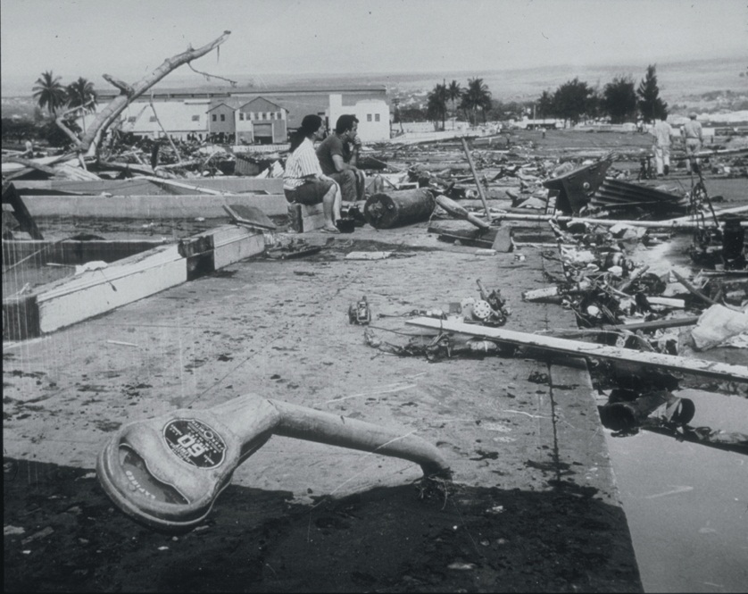
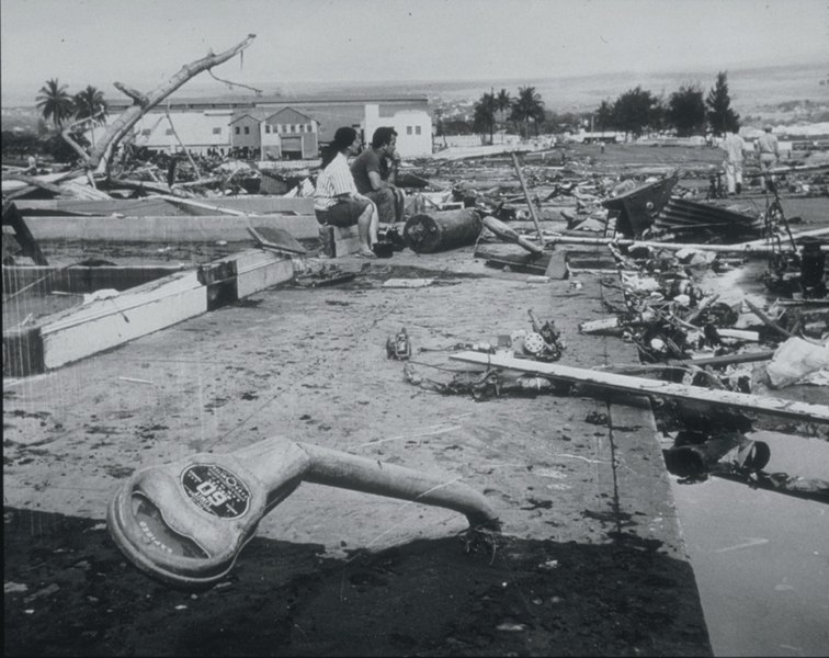
Hilo Hawaii, 1960; distruction from Tsunami
Σύνοψη
[επεξεργασία]
| Περιγραφή |
English: Tsunami Generated by Earthquake of May 22, 1960, Coast of Chile
The Waiakea area of Hilo, Hawaii, 10,000 km from the generating area. Parking meters were bent by the force of the debris-filled waves. Note the scattered debris and the gutted foundation. This tsunami, generated by the earthquake off the coast of central Chile, affected the entire Pacific Basin. One of the most seriously affected areas was Hilo, Hawaii, where 61 deaths and $24 million in damage occurred. In the area of maximum destruction, only buildings of reinforced concrete or structural steel, and a few others sheltered by these buildings, remained standing -- and even these were generally gutted. Frame buildings either were crushed or floated early to the limits of flooding. Photo credit: U.S. Navy |
| Ημερομηνία | |
| Πηγή | http://www.ngdc.noaa.gov/nndc/struts/results?EQ_0=4227&t=101634&s=80&d=80 |
| Δημιουργός | US Navy |
Αδειοδότηση
[επεξεργασία]
Αυτό η εικόνα ή αρχείο είναι έργο ναύτη ή υπάλληλου του Αμερικανικού Ναυτικού, τραβηγμένη ή φτιαγμένο κατά την διάρκεια των επίσημων καθηκόντων του. Ως έργο της Αμερικανικής ομοσπονδιακής κυβέρνησης, η εικόνα ή το αρχείο αυτό είναι κοινό κτήμα.
|
 | |
| Αυτό το αρχείο έχει χαρακτηριστεί ως απαλλαγμένο από γνωστούς περιορισμούς βάσει της νομοθεσίας περί πνευματικής ιδιοκτησίας, περιλαμβανομένων όλων των συναφών και συγγενικών δικαιωμάτων. | ||
Ιστορικό αρχείου
Πατήστε σε μια ημερομηνία/ώρα για να δείτε το αρχείο όπως εμφανιζόταν εκείνη την χρονική στιγμή.
| Ημερομηνία/Ώρα | Μικρογραφία | Διαστάσεις | Χρήστης | Σχόλιο | |
|---|---|---|---|---|---|
| τρέχον | 21:06, 21 Μαρτίου 2010 | | 838 × 665 (185 KB) | Q-ß (συζήτηση | Συνεισφορά) | {{Information |Description={{en|1=Tsunami Generated by Earthquake of May 22, 1960, Coast of Chile The Waiakea area of Hilo, Hawaii, 10,000 km from the generating area. Parking meters were bent by the force of the debris-filled waves. Note the scattered de |
Δεν μπορείτε να αντικαταστήσετε αυτό το αρχείο.
Χρήση αρχείου
Δεν υπάρχουν σελίδες που χρησιμοποιούν αυτό το αρχείο.
Καθολική χρήση αρχείου
Τα ακόλουθα άλλα wiki χρησιμοποιούν αυτό το αρχείο:
- Χρήση σε ckb.wikipedia.org
- Χρήση σε de.wikipedia.org
- Χρήση σε el.wikipedia.org
- Χρήση σε en.wikipedia.org
- Χρήση σε es.wikipedia.org
- Χρήση σε fa.wikipedia.org
- Χρήση σε fy.wikipedia.org
- Χρήση σε id.wikipedia.org
- Χρήση σε ja.wikipedia.org
- Χρήση σε ko.wikipedia.org
- Χρήση σε nl.wikipedia.org
- Χρήση σε pl.wikipedia.org
- Χρήση σε pt.wikipedia.org