File:Hindutagh-pass-aksai-chin-center2-1873.jpg
跳至導覽
跳至搜尋

預覽大小:420 × 600 像素。 其他解析度:168 × 240 像素 | 336 × 480 像素 | 537 × 768 像素 | 717 × 1,024 像素 | 1,386 × 1,980 像素。
原始檔案 (1,386 × 1,980 像素,檔案大小:409 KB,MIME 類型:image/jpeg)
說明
說明
添加單行說明來描述出檔案所代表的內容
摘要
[編輯]| 描述 |
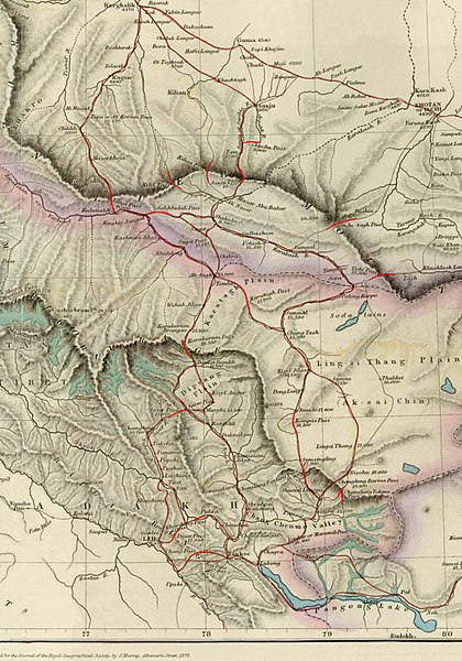
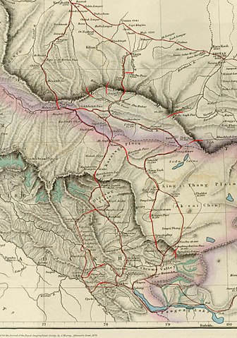
English: Image of map of the Baltistan, Aksai Chin, Chinese Turkestan in maps of Central Asia. The international border between the British Indian Empire (including the Kashmir region) and Chinese Turkestan is shown two-toned purple and pink. From the article, "On the Geographical Results of the Mission to Kashghar, under Sir T. Douglas Forsyth in 1873-74" by H. Trotter
Journal of the Royal Geographical Society of London, Vol. 48. (1878), pp. 173-234. Downloaded, resized to 33% of original size and annotated by Fowler&fowler«Talk» 23:52, 8 July 2007 (UTC) |
| 來源 | Article= "On the Geographical Results of the Mission to Kashghar, under Sir T. Douglas Forsyth in 1873-74" by H. Trotter, Journal of the Royal Geographical Society of London, Vol. 48. (1878), pp. 173-234. |
| 作者 | H. Trotter |
| 其他版本 |
.jpg)

授權條款
[編輯]
|
此為如實地拍攝平面藝術品的相片複製本。原作位於公有領域,是因下列原因:
維基媒體基金會的官方立場認為:「針對平面公有領域的藝術作品進行忠實重製,其重製後的照片也屬於公有領域。」
因此,可認定本重製照片屬於公有領域。在其他司法管轄區,再利用此照片可能會被限制;參見再利用PD-Art照片以獲得進一步資訊。 | ||||
原始上傳日誌
[編輯]
The original description page was here. All following user names refer to en.wikipedia.
- 2007-07-08 23:50 Fowler&fowler 1386×1980× (419033 bytes) Image of map of Central Asia from the article, [http://www.jstor.org/stable/1798763 "On the Geographical Results of the Mission to Kashghar, under Sir T. Douglas Forsyth in 1873-74"] by H. Trotter ''Journ
| 註解 | 該圖片含有註解:在維基媒體共享資源上查看註解 |
檔案歷史
點選日期/時間以檢視該時間的檔案版本。
| 日期/時間 | 縮圖 | 尺寸 | 使用者 | 備註 | |
|---|---|---|---|---|---|
| 目前 | 2010年1月19日 (二) 21:49 | | 1,386 × 1,980(409 KB) | File Upload Bot (Magnus Manske)(留言 | 貢獻) | {{BotMoveToCommons|en.wikipedia|year={{subst:CURRENTYEAR}}|month={{subst:CURRENTMONTHNAME}}|day={{subst:CURRENTDAY}}}} {{Information |Description={{en|Image of map of the Baltistan, Aksai Chin, Chinese Turkestan in maps of Central Asia. The internationa |
無法覆蓋此檔案。
檔案用途
下列2個頁面有用到此檔案:
全域檔案使用狀況
以下其他 wiki 使用了這個檔案:
- ar.wikipedia.org 的使用狀況
- as.wikipedia.org 的使用狀況
- en.wikipedia.org 的使用狀況
- es.wikipedia.org 的使用狀況
- fr.wikipedia.org 的使用狀況
- hi.wikipedia.org 的使用狀況
- it.wikipedia.org 的使用狀況
- no.wikipedia.org 的使用狀況
- or.wikipedia.org 的使用狀況
- pnb.wikipedia.org 的使用狀況
- ru.wikipedia.org 的使用狀況
- sh.wikipedia.org 的使用狀況
- sl.wikipedia.org 的使用狀況
- te.wikipedia.org 的使用狀況
- uz.wikipedia.org 的使用狀況
- vi.wikipedia.org 的使用狀況
- www.wikidata.org 的使用狀況
- zh.wikipedia.org 的使用狀況
詮釋資料
分類:
- History of Khotan
- Trade routes
- International relations of the Qing Dynasty
- Old maps of Xinjiang
- Old maps of Ladakh
- 1873 in Tibet
- Maps of Aksai Chin
- Old maps that include Leh
- Maps of the Kunlun Mountains
- Shyok River (India)
- Maps of East Turkestan
- Yarkand River
- Mountain passes of Ladakh
- Chang La
- Kay Pass
- Digar Pass
- Khardung La
- Changlung Yokma Pass
- Changlung Barma Pass
- Changlung Pantung Pass
- Kompas Pass
- Saser Pass
- Karakorum Pass
- Ilchi Pass
- Muztagh Pass