File:Hinnamnor 2022-09-01 0000Z.jpg
跳至導覽
跳至搜尋

預覽大小:480 × 600 像素。 其他解析度:192 × 240 像素 | 384 × 480 像素 | 614 × 768 像素 | 819 × 1,024 像素 | 1,638 × 2,048 像素 | 3,200 × 4,000 像素。
原始檔案 (3,200 × 4,000 像素,檔案大小:15.46 MB,MIME 類型:image/jpeg)
說明
說明
添加單行說明來描述出檔案所代表的內容
摘要
[編輯]| 描述 |
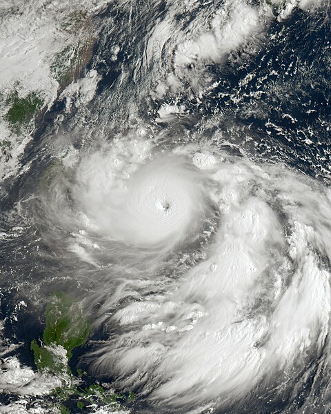
English: This authentic true-color depiction of Typhoon Hinnamnor, locally referred to as "Henry" in the Philippines, was captured on September 1, 2022, at 0:00 UTC (8:00 AM Taiwan Local Time) by the Advanced Himawari Imager (AHI) instrument aboard the JMA's Himawari 8 satellite. Hinnamnor emerged as a compact and formidable typhoon originating from a tropical disturbance northeast of the Marshall Islands during the 2022 Pacific typhoon season in late August. At the time of imaging, Hinnamnor had traversed the Okinawa Islands and positioned itself just east of Taiwan, transitioning into the area of responsibility of PAGASA. Subsequently, it made an impact on the Korean Peninsula, followed by a trajectory towards extratropical conversion, affecting Eastern Russia while traversing the Sea of Japan. During the moment of capture, Hinnamnor had reached its secondary peak intensity, categorized as a Category 5 equivalent typhoon, with wind speeds reaching 160 mph (260 km/h) (140 knots) on the 1-minute Saffir-Simpson scale and 115 mph (185 km/h) on the 10-minute JMA typhoon scale, qualifying it as a "very strong typhoon" by those standards. Additionally, the typhoon exhibited a minimum central pressure of 920 mbar (27.2 inHg) at the time of observation. |
| 日期 | |
| 來源 | https://re.ssec.wisc.edu |
| 作者 | University of Wisconsin-Madison, Space Science and Engineering Center |
授權條款
[編輯]This image was produced by the SSEC/CIMSS, University of Wisconsin–Madison. All the images published on their website can be freely used, as long as the source is acknowledged. (disclaimer (archive))
|
 |

檔案歷史
點選日期/時間以檢視該時間的檔案版本。
| 日期/時間 | 縮圖 | 尺寸 | 用戶 | 備註 | |
|---|---|---|---|---|---|
| 目前 | 2024年9月7日 (六) 17:03 | | 3,200 × 4,000(15.46 MB) | Zzzs(對話 | 貢獻) | unexplained revert |
| 2024年9月7日 (六) 12:38 |  | 1,550 × 2,000(4.36 MB) | Phanfone Vongfong 2014(對話 | 貢獻) | Reverted to version as of 15:04, 25 May 2023 (UTC) | |
| 2023年10月20日 (五) 19:44 |  | 3,200 × 4,000(15.46 MB) | TheWxResearcher(對話 | 貢獻) | m | |
| 2023年10月20日 (五) 19:34 |  | 3,200 × 4,000(15.45 MB) | TheWxResearcher(對話 | 貢獻) | Color correction. | |
| 2023年5月27日 (六) 21:38 |  | 2,500 × 3,200(9.6 MB) | TheWxResearcher(對話 | 貢獻) | Reverted to version as of 16:37, 22 January 2023 (UTC) | |
| 2023年5月25日 (四) 15:04 |  | 1,550 × 2,000(4.36 MB) | Papacyclones(對話 | 貢獻) | Reverted to version as of 02:07, 1 September 2022 (UTC) | |
| 2023年1月22日 (日) 16:37 |  | 2,500 × 3,200(9.6 MB) | TheWxResearcher(對話 | 貢獻) | Cropped, okay definitely the last update not going to touch it anymore. | |
| 2023年1月22日 (日) 16:34 |  | 2,700 × 3,200(10.42 MB) | TheWxResearcher(對話 | 貢獻) | I reprojected this image onto a flat map like worldview so the typhoon won't appear slanted, this will be the last update on this image. | |
| 2022年12月14日 (三) 20:28 |  | 2,500 × 3,300(9.29 MB) | TheWxResearcher(對話 | 貢獻) | m | |
| 2022年12月14日 (三) 19:07 |  | 2,500 × 3,300(8.78 MB) | TheWxResearcher(對話 | 貢獻) | 500m resolution and focused more on the Typhoon |
無法覆蓋此檔案。
檔案用途
沒有使用此檔案的頁面。
全域檔案使用狀況
以下其他 wiki 使用了這個檔案:
- en.wikipedia.org 的使用狀況
- es.wikipedia.org 的使用狀況
- fa.wikipedia.org 的使用狀況
- ja.wikipedia.org 的使用狀況
- ko.wikipedia.org 的使用狀況
- pt.wikipedia.org 的使用狀況
- th.wikipedia.org 的使用狀況
- uk.wikipedia.org 的使用狀況
- vi.wikipedia.org 的使用狀況
- zh-min-nan.wikipedia.org 的使用狀況
- zh.wikipedia.org 的使用狀況