File:Hizen-torishima mlit1978.jpg
Aller à la navigation
Aller à la recherche

Taille de cet aperçu : 450 × 600 pixels. Autres résolutions : 180 × 240 pixels | 360 × 480 pixels | 768 × 1 024 pixels.
Fichier d’origine (768 × 1 024 pixels, taille du fichier : 153 kio, type MIME : image/jpeg)
Légendes
Légendes
Ajoutez en une ligne la description de ce que représente ce fichier
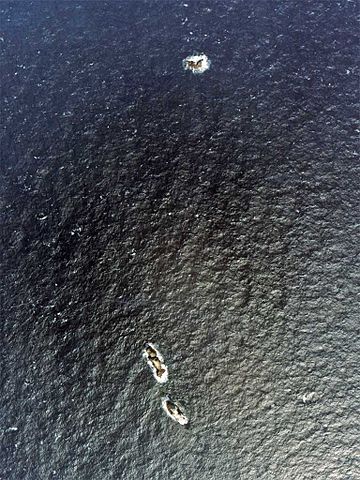
en: Aerial Photograph of Torishima (Hizen-Torishima) at Japan in 1978.
ja: 鳥島(肥前鳥島)の航空写真。画像上方から、北岩、中岩、南岩の3つの岩礁がわかる。(1978年)

|
Le détenteur des droits d’auteur de ce fichier, Ministère du Territoire, des Infrastructures, des Transports et du Tourisme, autorise n’importe qui à l’utiliser pour n’importe quelle utilisation, pourvu que le détenteur des droits d’auteur soit correctement attribué. La redistribution, les œuvres dérivées, l’utilisation commerciale et toutes les autres utilisations sont autorisées. |
Attribution:
Copyright © National Land Image Information (Color Aerial Photographs), Ministry of Land, Infrastructure, Transport and Tourism
|
 |
This image is copyrighted by the Ministry of Land, Infrastructure, Transport and Tourism of Japan. For terms of use, see the stipulation to use of National Land Information (in Japanese) and message from MLIT (in Japanese and English). When you display this image on an article, include the following phrase in the description: "Made based on National Land Image Information (Color Aerial Photographs), Ministry of Land, Infrastructure, Transport and Tourism".
|
Historique du fichier
Cliquer sur une date et heure pour voir le fichier tel qu'il était à ce moment-là.
| Date et heure | Vignette | Dimensions | Utilisateur | Commentaire | |
|---|---|---|---|---|---|
| actuel | 22 avril 2007 à 06:37 | | 768 × 1 024 (153 kio) | Tdk~commonswiki (d | contributions) | en: Aerial Photograph of Torishima (Hizen-Torishima) at Japan in 1978. ja: 鳥島(肥前鳥島)の航空写真。画像上方から、北岩、中岩、南岩の3つの岩礁がわかる。(1978年) {{AerialPhotograph-mlitJP}} |
Vous ne pouvez pas remplacer ce fichier.
Utilisations locales du fichier
La page suivante utilise ce fichier :
Utilisations du fichier sur d’autres wikis
Les autres wikis suivants utilisent ce fichier :
- Utilisation sur fr.wikipedia.org
- Utilisation sur ja.wikipedia.org
- Utilisation sur ko.wikipedia.org
- Utilisation sur www.wikidata.org