File:Hobucken Bridge North Carolina.jpg
Przejdź do nawigacji
Przejdź do wyszukiwania

Rozmiar podglądu – 800 × 534 pikseli. Inne rozdzielczości: 320 × 214 pikseli | 640 × 427 pikseli | 1024 × 683 pikseli | 1500 × 1001 pikseli.
Rozmiar pierwotny (1500 × 1001 pikseli, rozmiar pliku: 795 KB, typ MIME: image/jpeg)
Podpisy
Podpisy
Dodaj jednolinijkowe objaśnienie tego, co ten plik pokazuje
| Opis |
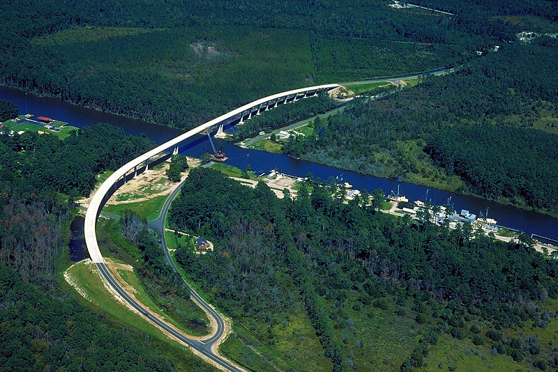
English: Aerial view of a stretch of the Intracoastal Waterway in Pamlico County, North Carolina, USA. The U.S. Army Corps of Engineers constructed the Hobucken Bridge over the waterway to replace an old swing-style drawbridge. The bridge carries NC state routes 33 and 304 over the waterway.
Coordinates: 35°14′46.37″N 76°35′29.74″W / 35.2462139°N 76.5915944°W |
|||
| Miejsce | Pamlico County, North Carolina, USA | |||
| Data | (Caveat: Dates provided by U.S. Army Corps of Engineers Digital Visual Library are not reliable and are often wrong.) | |||
| Źródło |
U.S. Army Corps of Engineers Digital Visual Library Image page Image description page Digital Visual Library home page |
|||
| Autor | Bud Davis, U.S. Army Corps of Engineers | |||
| Licencja (Ponowne użycie tego pliku) |
|
Historia pliku
Kliknij na odpowiedniej dacie/czasie, aby zobaczyć wersję pliku z tamtego okresu.
| Data/czas | Miniatura | Wymiary | Użytkownik | Opis | |
|---|---|---|---|---|---|
| aktualny | 04:26, 26 kwi 2007 | | 1500 × 1001 (795 KB) | DanMS (dyskusja | edycje) | {{Information | Description = {{en|Aerial view of a stretch of the Intracoastal Waterway in Pamlico County, North Carolina, USA. The U.S. Army Corps of Engineers constructed the Hobucken Bridge over the waterway to replace an old swing-style drawbridge |
Nie możesz nadpisać tego pliku.
Lokalne wykorzystanie pliku
Następujące strony korzystają z tego pliku:
Globalne wykorzystanie pliku
Ten plik jest wykorzystywany także w innych projektach wiki:
- Wykorzystanie na af.wikipedia.org
- Wykorzystanie na ar.wikipedia.org
- Wykorzystanie na arz.wikipedia.org
- Wykorzystanie na ceb.wikipedia.org
- Wykorzystanie na ce.wikipedia.org
- Wykorzystanie na cy.wikipedia.org
- Wykorzystanie na de.wikipedia.org
- Wykorzystanie na en.wikipedia.org
- Wykorzystanie na eo.wikipedia.org
- Wykorzystanie na es.wikipedia.org
- Wykorzystanie na fa.wikipedia.org
- Wykorzystanie na fi.wikipedia.org
- Wykorzystanie na fr.wikipedia.org
- Wykorzystanie na ga.wikipedia.org
- Wykorzystanie na he.wikipedia.org
- Wykorzystanie na hu.wikipedia.org
- Wykorzystanie na it.wikipedia.org
- Wykorzystanie na ja.wikipedia.org
- Wykorzystanie na ko.wikipedia.org
- Wykorzystanie na nl.wikipedia.org
- Wykorzystanie na no.wikipedia.org
- Wykorzystanie na pl.wikipedia.org
- Wykorzystanie na pt.wikipedia.org
- Wykorzystanie na ru.wikipedia.org
- Wykorzystanie na simple.wikipedia.org
- Wykorzystanie na sr.wikipedia.org
- Wykorzystanie na tt.wikipedia.org
- Wykorzystanie na ur.wikipedia.org
- Wykorzystanie na www.wikidata.org