File:Hooker Map of the State of Coahuila and Texas 1833 UTA.jpg
Archivo original (3516 × 2793 píxeles; tamaño de archivo: 9,26 MB; tipo MIME: image/jpeg)
Leyendas
Leyendas
Resumen[editar]
| Título |
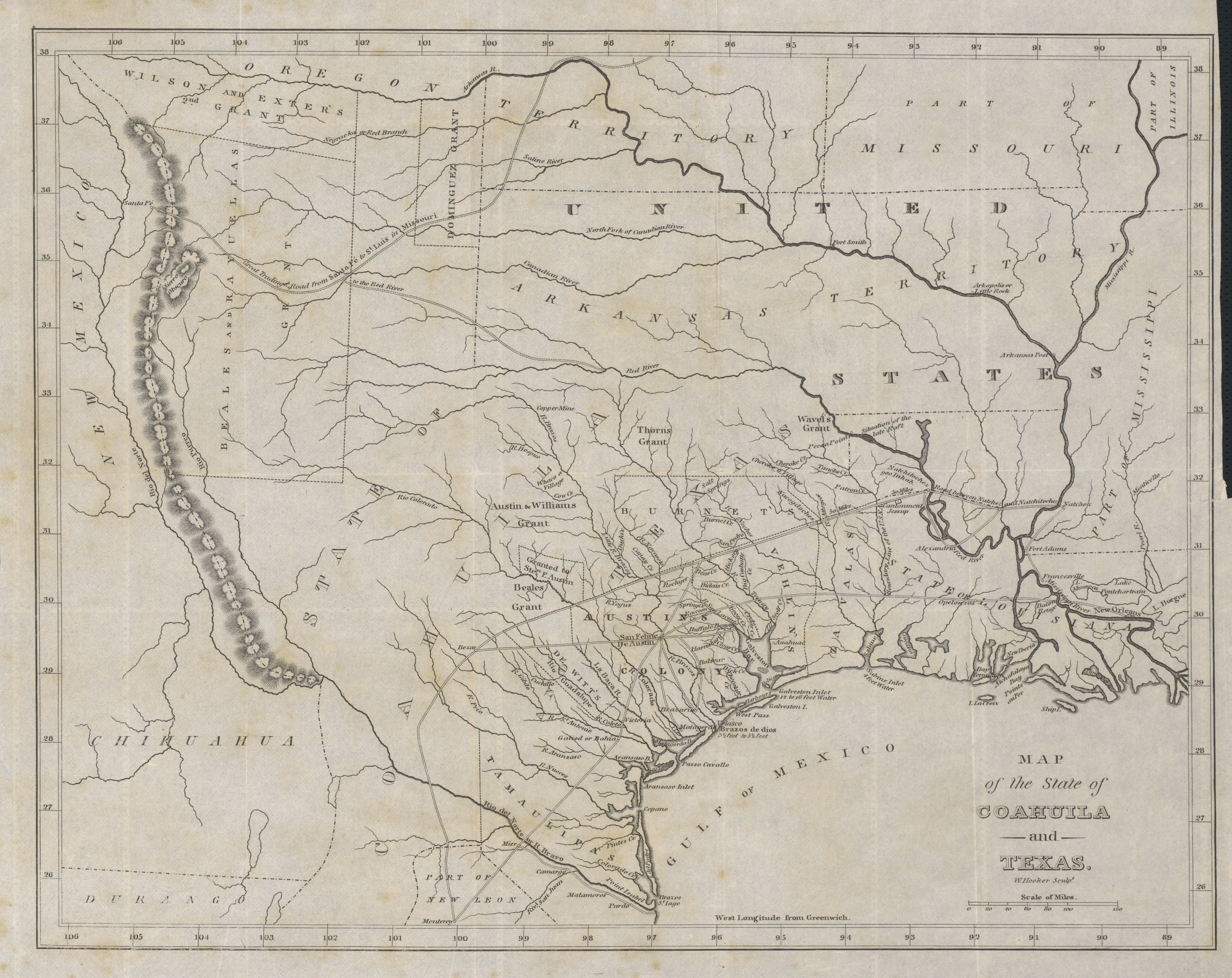
English: Map of the State of Coahuila and Texas |
||||||||||||||||||||||||||
| Descripción |
English: Philadelphia engraver, printer, map publisher, and instrument maker William Hooker's Map of Coahuila and Texas first appeared in an 1833 promotional book on Texas by Mary Austin Holley (1784-1846), a first cousin of the famous Texas colonizer Stephen F. Austin. Holley and her publisher, Armstrong & Plaskitt of Baltimore substituted Hooker's map when Henry S. Tanner, the publisher of Stephen F. Austin's large map of Texas, refused to allow the latter to be used in the book. Hooker's map shows the Austin Colony capital town of San Felipe de Austin at the center of roads leading to a number of settlements including Bexar (San Antonio de Bexar), Victoria and Goliad or Bahia, Matagorda, Brazaria (sic, Brazoria), Harrisburg and Buffalo Bayou as well as a road connecting to the older Camino Real or old Spanish road between Bexar and Nacogdoches. Lands granted to individuals under the Mexican empresario system are shown. In addition to Stephen F. Austin's grants awarded in 1821 (confirmed in 1823 and extended by further contracts in 1825, 1827, and 1828), these include the grants of Green DeWitt (contract awarded in 1825), Frost Thorn (1825), Benjamin R. Milam (1826), David G. Burnet (1826), Arthur G. Wavell (1826), Joseph Vehlein (1826 and 1828), Lorenzo de Zavala (1829), Juan Dominguez y Valdez (1829), Richard Exter (1826, 1828), John Charles Beale (1830). The lands in west Texas granted to Beale and José Manuel Royuela and to Austin and his partner Samuel May Williams in 1832 are the latest to appear on the map. References to other land grants are missing but some would appear on later editions in 1834 and 1836. |
||||||||||||||||||||||||||
| Fecha | |||||||||||||||||||||||||||
| Fuente | UTA Libraries Cartographic Connections: mapa / texto | ||||||||||||||||||||||||||
| Creador |
|
||||||||||||||||||||||||||
| Adquisición |
English: The University of Texas at Arlington Libraries Special Collections, Gift of Jenkins Garrett |
||||||||||||||||||||||||||
| Geotemporal data | |||||||||||||||||||||||||||
| Map location |
México Texas |
||||||||||||||||||||||||||
| Georeferencing | If inappropriate please set warp_status = skip to hide. | ||||||||||||||||||||||||||
| Bibliographic data | |||||||||||||||||||||||||||
| Publicación |
Texas. Observations, Historical, Geographical and Descriptive, in a Series of Letters Written during a Visit to Austin's Colony, with a view to a permanent settlement in that country, in the Autumn of 1831 |
||||||||||||||||||||||||||
| Autor |
|
||||||||||||||||||||||||||
| Lugar de publicación | Baltimore | ||||||||||||||||||||||||||
| Editorial |
Armstrong & Plaskitt |
||||||||||||||||||||||||||
| Archival data | |||||||||||||||||||||||||||
| Colección |
|
||||||||||||||||||||||||||
| Dimensiones | altura: 27 cm; ancho: 34 cm | ||||||||||||||||||||||||||
| Técnica | grabado sobre papel | ||||||||||||||||||||||||||
| artwork-references |
Huseman, Ben W. (2014) The Price of Manifest Destiny: Maps Relating to the Southwest Borderlands, 1800-1866, Arlington: The University of Texas at Arlington Libraries, p. 16 Streeter, Thomas W. (1983) Bibliography of Texas 1795-1845 (2.o ed.), Woodbridge: Research Publications, Inc., pp. 376–377, 383, 397 «Revised and Enlarged by Archibald Hanna with a Guide to the Microfilm Collection. First published by Oxford University Press, 1955.» Davis, Marty, et al (2007) Going to Texas: Five Centuries of Texas Maps, Fort Worth: Texas Christian University Press, nº17 , p. 35 Day, James M. (1964) Maps of Texas 1527-1900, Austin: The Pemberton Press, pp. 18, 22 |
||||||||||||||||||||||||||
Licencia[editar]

|
This file was provided to Wikimedia Commons by the University of Texas at Arlington Libraries as part of a cooperation project. The University of Texas at Arlington Libraries is part of the University of Texas at Arlington, a public research university located in Arlington, Texas.
|
|
Este material está en dominio público en los demás países donde el derecho de autor se extiende por 100 años (o menos) tras la muerte del autor. Esta obra está en el dominio público en los Estados Unidos porque fue publicada (o registrada con la Oficina del Derecho de Autor de los E.E. U.U.) antes del 1 de enero de 1929. | |
| Esta obra ha sido identificada como libre de las restricciones conocidas en virtud del derecho de autor, incluyendo todos los derechos conexos. | |
Historial del archivo
Haz clic sobre una fecha y hora para ver el archivo tal como apareció en ese momento.
| Fecha y hora | Miniatura | Dimensiones | Usuario | Comentario | |
|---|---|---|---|---|---|
| actual | 19:37 23 jul 2019 | | 3516 × 2793 (9,26 MB) | Michael Barera (discusión | contribs.) | == {{int:filedesc}} == {{Map |title = ''Map of the State of Coahuila and Texas'' |description = {{en|Philadelphia engraver, printer, map publisher, and instrument maker William Hooker's Map of Coahuila and Texas first appeared in an 1833 promotional book on Texas by Mary Austin Holley (1784-1846), a first cousin of the famous Texas colonizer Stephen F. Austin. Holley and her publisher, Armstrong & Plaskitt of Baltimore substituted Hooker's map when Henry S. Tanner, the pub... |
No puedes sobrescribir este archivo.
Usos del archivo
No hay páginas que enlacen a este archivo.
Uso global del archivo
Las wikis siguientes utilizan este archivo:
- Uso en ca.wikipedia.org
- Uso en cs.wikipedia.org
- Uso en el.wikipedia.org
- Uso en en.wikipedia.org
- Uso en es.wikipedia.org
- Uso en ja.wikipedia.org
- Uso en ro.wikipedia.org
- Uso en sv.wikipedia.org