File:Hooker Map of the State of Coahuila and Texas 1836 UTA.jpg

元のファイル (4,122 × 3,436 ピクセル、ファイルサイズ: 11.07メガバイト、MIME タイプ: image/jpeg)
キャプション
キャプション
概要
[編集]
| 題名 |
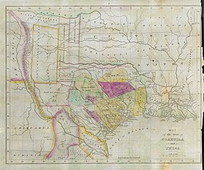
English: Map of the State of Coahuila and Texas |
||||||||||||||||||||||||||
| 記述 |
English: Philadelphia engraver, printer, map publisher, and instrument maker William Hooker's Map of Coahuila and Texas first appeared in an 1833 promotional book on Texas by Mary Austin Holley (1784-1846), a first cousin of the famous Texas colonizer Stephen F. Austin. Holley and her first publisher, Armstrong & Plaskitt of Baltimore substituted Hooker's map when Henry S. Tanner, the publisher of Stephen F. Austin's large map of Texas, refused to allow the latter to be used in the book. Both the 1836 map and book have some significant updates from the earlier map and book. Like the map by Hooker that appeared in A Visit to Texas, published by Goodrich & Wiley in New York in 1834, the 1836 map contains all the details of the earlier 1833 version but indirectly also refers to empresarios John McMullen and James McGloin, James Power, John Cameron, other new details such as "Herds of Buffalo" and "Droves of Wild Cattle & Horses" (phrases copied directly from the Austin-Tanner map) and peaks in the west, "Presidio de Rio Grand" [sic], additional towns across the Rio Grande in Chihuahua and Coahuila, the Cross Timbers, Fort Tenoxtitlan, Comanche Indian lands in the west, Cherokee, Creek, and Choctaw Indian lands north of the Red River. In addition, this 1836 map adds other details, such as references to the grants of Juan Antonio Padilla and Thomas Jefferson Chambers in the panhandle (awarded in 1830), and those of John Charles Beale and Dr. James Grant in the west. Further, the map includes the towns of Bastrop, Gonzales, Cole's Settlement (Independence), Montezuma, Orizumba, Columbia, Bell's Landing, and De Leon's colony. The words "now Filisola" are stamped in northeast Texas next to Thorn's Grant – referring to an empresario land grant awarded in 1831 to Italian-born Mexican Army General Vicente Filisola (1789-1850). Handwritten additions in ink on the map are references to Benjamin Milam's grant in the far northeast and the towns of Washington (on the Brazos), Corpus Christi, and [San] Augustine. |
||||||||||||||||||||||||||
| 日付 | |||||||||||||||||||||||||||
| 原典 | UTA Libraries Cartographic Connections: 地図 / テキスト | ||||||||||||||||||||||||||
| 作者 |
|
||||||||||||||||||||||||||
| 受入/取得方法 |
English: The University of Texas at Arlington Libraries Special Collections, Gift of Jenkins Garrett |
||||||||||||||||||||||||||
| Geotemporal data | |||||||||||||||||||||||||||
| Map location |
メキシコ テキサス州 |
||||||||||||||||||||||||||
| Georeferencing | If inappropriate please set warp_status = skip to hide. | ||||||||||||||||||||||||||
| Bibliographic data | |||||||||||||||||||||||||||
| 出版物 |
Texas |
||||||||||||||||||||||||||
| 作者 |
|
||||||||||||||||||||||||||
| ページ番号 | Frontispiece | ||||||||||||||||||||||||||
| 出版地 | レキシントン | ||||||||||||||||||||||||||
| 出版者 |
J. Clarke & Co. |
||||||||||||||||||||||||||
| Archival data | |||||||||||||||||||||||||||
| コレクション |
|
||||||||||||||||||||||||||
| 寸法 | 高さ: 27 cm;幅: 34 cm | ||||||||||||||||||||||||||
| 技法 | 彩色された エングレービング / 紙 | ||||||||||||||||||||||||||
| artwork-references |
Huseman, Ben W. (2014年) The Price of Manifest Destiny: Maps Relating to the Southwest Borderlands, 1800-1866、アーリントン: The University of Texas at Arlington Libraries、p. 16 Streeter, Thomas W. (1983年) Bibliography of Texas 1795-1845 (第2 ed.)、Woodbridge: Research Publications, Inc.、pp. 328, 376–377, 383, 397 "Revised and Enlarged by Archibald Hanna with a Guide to the Microfilm Collection. First published by Oxford University Press, 1955." Davis, Marty, et al (2007年) Going to Texas: Five Centuries of Texas Maps、フォート・ワース: Texas Christian University Press、17 番、p. 35 Day, James M. (1964年) Maps of Texas 1527-1900、オースティン: The Pemberton Press、pp. 18, 22 "No. 220" in (2009年) Dorothy Sloan Books Auction 22 catalog、オースティン |
||||||||||||||||||||||||||
ライセンス
[編集]

|
This file was provided to Wikimedia Commons by the University of Texas at Arlington Libraries as part of a cooperation project. The University of Texas at Arlington Libraries is part of the University of Texas at Arlington, a public research university located in Arlington, Texas.
|
|
著作者が1846年に死亡しているため、この著作物は、著作権の保護期間が著作者の死後100年以下である国・地域においてパブリックドメインの状態にあります。 この著作物は1929年1月1日以前に公表され、又はアメリカ合衆国著作権局に登録されたため、アメリカ合衆国においてパブリックドメインの状態にあります。 | |
| このファイルは著作権法の既知の制約(隣接権や関連する権利を含む)から自由であると特定されています。 | |
ファイルの履歴
過去の版のファイルを表示するには、その版の日時をクリックしてください。
| 日付と時刻 | サムネイル | 寸法 | 利用者 | コメント | |
|---|---|---|---|---|---|
| 現在の版 | 2019年7月23日 (火) 20:46 | | 4,122 × 3,436 (11.07メガバイト) | Michael Barera (トーク | 投稿記録) | ‹== {{int:filedesc}} == {{Map |title = ''Map of the State of Coahuila and Texas'' |description = {{en|Philadelphia engraver, printer, map publisher, and instrument maker William Hooker's ''Map of Coahuila and Texas'' first appeared in an 1833 promotional book on Texas by Mary Austin Holley (1784-1846), a first cousin of the famous Texas colonizer Stephen F. Austin. Holley and her first publisher, Armstrong & Plaskitt of Baltimore substituted Hooker's map when Henry S. Tann... |
このファイルは上書きできません。
ファイルの使用状況
このファイルを使用しているページはありません。
グローバルなファイル使用状況
以下に挙げる他のウィキがこの画像を使っています:
- ca.wikipedia.org での使用状況
- cs.wikipedia.org での使用状況
- el.wikipedia.org での使用状況
- en.wikipedia.org での使用状況
- es.wikipedia.org での使用状況
- ja.wikipedia.org での使用状況
- ro.wikipedia.org での使用状況
- sv.wikipedia.org での使用状況