File:Hungary 13th cent.png
Zur Navigation springen
Zur Suche springen

Größe dieser Vorschau: 800 × 595 Pixel. Weitere Auflösungen: 320 × 238 Pixel | 640 × 476 Pixel | 1.024 × 762 Pixel | 1.280 × 952 Pixel | 1.757 × 1.307 Pixel.
Originaldatei (1.757 × 1.307 Pixel, Dateigröße: 451 KB, MIME-Typ: image/png)
Bildtexte
Kurzbeschreibungen
Ergänze eine einzeilige Erklärung, was diese Datei darstellt.
Beschreibung
[Bearbeiten]
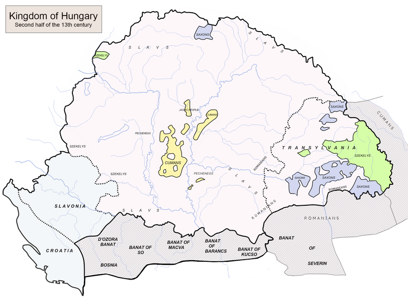
| Beschreibung | Hungary in the late 1200s (including Kingdom of Croatia in personal union with Hungary) |
| Quelle | Eigenes Werk (Source:https://djnaploja.files.wordpress.com/2015/11/magyar-kirc3a1lysc3a1g-xiii-sz.jpg) |
| Urheber | Fz22 |
Lizenz
[Bearbeiten]
| Ich, der Urheberrechtsinhaber dieses Werkes, veröffentliche es als gemeinfrei. Dies gilt weltweit. In manchen Staaten könnte dies rechtlich nicht möglich sein. Sofern dies der Fall ist: Ich gewähre jedem das bedingungslose Recht, dieses Werk für jedweden Zweck zu nutzen, es sei denn, Bedingungen sind gesetzlich erforderlich. |
Dateiversionen
Klicke auf einen Zeitpunkt, um diese Version zu laden.
| Version vom | Vorschaubild | Maße | Benutzer | Kommentar | |
|---|---|---|---|---|---|
| aktuell | 18:15, 18. Feb. 2024 | | 1.757 × 1.307 (451 KB) | OrionNimrod (Diskussion | Beiträge) | I added the proper title, which is smaller and do not hide the north area. Following better borders, and put Pecheneg name only where I can see the original map |
| 18:46, 7. Mai 2021 |  | 1.757 × 1.307 (464 KB) | ~riley (Diskussion | Beiträge) | Reverted to version as of 11:16, 20 December 2019 (UTC) Post-edit war cleanup, consensus achieved at Special:Permalink/558633036#Ceha | |
| 22:22, 6. Mai 2021 |  | 1.757 × 1.307 (458 KB) | ~riley (Diskussion | Beiträge) | Reverted to version as of 08:32, 27 April 2021 (UTC) | |
| 12:53, 3. Mai 2021 |  | 1.757 × 1.307 (462 KB) | Ceha (Diskussion | Beiträge) | Reverted to version as of 13:26, 21 April 2021 (UTC) please look at the source http://www.historicaltextarchive.com/hungary/hu13.gif you are constantly puting Virovitica and similar towns out of Croatia | |
| 08:32, 27. Apr. 2021 |  | 1.757 × 1.307 (458 KB) | Mhare (Diskussion | Beiträge) | Reverted to version as of 10:55, 21 April 2021 (UTC) please don't change if you do not have references. | |
| 13:26, 21. Apr. 2021 |  | 1.757 × 1.307 (462 KB) | Ceha (Diskussion | Beiträge) | Reverted to version as of 20:47, 19 January 2021 (UTC), as stated in previous cases | |
| 10:55, 21. Apr. 2021 |  | 1.757 × 1.307 (458 KB) | Mhare (Diskussion | Beiträge) | Reverted to version as of 11:42, 10 January 2021 (UTC) even that picture (which is without source anyway) has the borders as is in original picture, not the one you modified. | |
| 20:47, 19. Jan. 2021 |  | 1.757 × 1.307 (462 KB) | Ceha (Diskussion | Beiträge) | Reverted to version as of 03:31, 4 January 2021 (UTC) Again, this http://www.historicaltextarchive.com/hungary/hu13.gif is the source | |
| 11:42, 10. Jan. 2021 |  | 1.757 × 1.307 (458 KB) | Mhare (Diskussion | Beiträge) | Reverted to version as of 12:47, 12 August 2020 (UTC) POV pushing without sources, not an original uploader, next time I'm reporting. | |
| 03:31, 4. Jan. 2021 |  | 1.757 × 1.307 (462 KB) | Ceha (Diskussion | Beiträge) | Reverted to version as of 18:01, 2 July 2020 (UTC), as discussed before |
Du kannst diese Datei nicht überschreiben.
Dateiverwendung
Die folgenden 12 Seiten verwenden diese Datei:
- Atlas of Bosnia and Herzegovina
- Atlas of Croatia
- Atlas of Hungary
- Atlas of Republika Srpska
- Atlas of Slovakia
- Atlas of Székely Land
- User:J budissin/Uploads/BiH/2016 January 11-20
- User:J budissin/Uploads/BiH/2016 October 1-10
- User:J budissin/Uploads/BiH/2017 September 11-20
- User:J budissin/Uploads/BiH/2018 March 1-10
- File:Hungary 13th centx.png (Dateiweiterleitung)
- Category:Banate of Severin
Globale Dateiverwendung
Die nachfolgenden anderen Wikis verwenden diese Datei:
- Verwendung auf ar.wikipedia.org
- Verwendung auf ba.wikipedia.org
- Verwendung auf bg.wikipedia.org
- Verwendung auf bn.wikipedia.org
- Verwendung auf cs.wikipedia.org
- Verwendung auf de.wikipedia.org
- Verwendung auf el.wikipedia.org
- Verwendung auf en.wikipedia.org
- Stephen V of Hungary
- March (territory)
- Ban (title)
- Béla IV of Hungary
- Kingdom of Hungary
- Cumans
- Transylvanian Saxons
- Great Hungarian Plain
- Portal:Hungary
- Germans of Romania
- User:Fz22
- History of Transylvania
- Vlach law
- Kunság
- Roman Catholic Diocese of Cumania
- History of Hungary
- Banate of Severin
- Duke of Transylvania
- Banate of Só
- Kingdom of Hungary (1000–1301)
- Second Mongol invasion of Hungary
- Theodore Vejtehi
- Henry I Kőszegi
- Template:Did you know nominations/Kingdom of Hungary (1000–1301)
- Judge of the Cumans
- Battle of Lake Hód
- Philip III, Bishop of Fermo
- Transylvanian Saxon University
- User:Falcaorib/Austria-Hungary
- Verwendung auf eo.wikipedia.org
- Verwendung auf es.wikipedia.org
Weitere globale Verwendungen dieser Datei anschauen.
Metadaten
Kategorien:
- Maps of the history of Hungary in the Árpád age
- Hungary in the 13th century
- Maps of the history of Transylvania
- Voivodeship of Transylvania
- Maps of Székely Land
- Maps of Kunság
- Maps of the history of Croatia in the Middle Ages
- Maps of the history of Slavonia
- Maps of the Banate of Bosnia
- Maps of the history of Mačva
- Banate of Severin
- Usora (region)
- Soli (region)