File:Hungary 1956-1990.svg
跳去導覽
跳去搵嘢

呢個「SVG」檔案嘅呢個「PNG」預覽嘅大細:450 × 456 像素。 第啲解像度:237 × 240 像素 | 474 × 480 像素 | 758 × 768 像素 | 1,011 × 1,024 像素 | 2,021 × 2,048 像素。
原本檔案 (SVG檔案,表面大細: 450 × 456 像素,檔案大細:475 KB)
Captions
Captions
Add a one-line explanation of what this file represents
摘要[編輯]


.svg)
.svg)
.svg)
.svg)
.svg)


.svg)
.svg)
.svg)


.png)
.png)


.svg)


.svg)

.svg)


.svg)
.svg)
.svg)
.svg)


.svg)
.png)


.svg)


.svg)
.svg)


.svg)


.svg)


.svg)
.svg)
.svg)
.svg)
.svg)
.svg)
.svg)
_cropped.svg)
.svg)
.svg)
.svg)
.svg)
.svg)
.svg)
.svg)
.svg)
.svg)
.svg)
.svg)
.svg)
.svg)
.svg)
.svg)
.svg)
.svg)
.svg)
.svg)
.svg)
.svg)
.svg)
.svg)
.svg)
.svg)
.svg)
.svg)
.svg)
.svg)
.svg)
.svg)
.svg)
.svg)
.svg)
.svg)
.svg)
.svg)
.svg)
.svg)
.svg)
.svg)
.svg)
.svg)
.svg)
.svg)
| This is a retouched picture, which means that it has been digitally altered from its original version. The original can be viewed here: Blank map of Europe 1956-1990.svg:
|
協議[編輯]
我,呢份作品嘅作者,決定用以下許可發佈呢件作品:
呢個檔案用共享創意 姓名標示-非商業性-相同方式分享3.0 未本地化版本條款授權。
- 你可以:
- 去分享 – 複製、發佈同傳播呢個作品
- 再改 – 創作演繹作品
- 要遵照下面嘅條件:
- 署名 – 你一定要畀合適嘅表彰、畀返指向呢個授權條款嘅連結,同埋寫明有無改過嚟。你可以用任何合理方式去做,但唔可以用任何方式暗示授權人認可咗你或者你嘅使用方式。
- 相同方式分享 – 如果你用任何方式改過呢個作品,你必須要用返原本或者相似嘅條款發佈。
Original upload log[編輯]
This image is a derivative work of the following images:
- File:Blank_map_of_Europe_1956-1990.svg licensed with Cc-by-sa-3.0
- 2011-10-30T04:43:42Z Alphathon 450x456 (485146 Bytes) == {{int:filedesc}} == {{Information |Description={{en|Blank map of Europe showing national borders as they stood from 1956-1990.}} |Source=*[[:File:Blank_map_of_Europe.svg|]] |Date=2011-10-30 04:42 (UTC) |Author=*[[:File:Bla
檔案歷史
撳個日期/時間去睇響嗰個時間出現過嘅檔案。
| 日期/時間 | 縮圖 | 尺寸 | 用戶 | 註解 | |
|---|---|---|---|---|---|
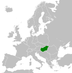
| 現時 | 2011年11月26號 (六) 00:55 | | 450 × 456(475 KB) | StalwartUK(傾偈 | 貢獻) | == {{int:filedesc}} == {{Information |Description={{en|Map of People's Republic of Hungary as it was from 1949-1989. Surrounding countries accurate from 1956-1990.}} |Source=*[[:File:Blank_map_of_Europe_1956-1990.svg|B |
你無得衾咗個檔案。
檔案用途
多過100版用到呢個檔。 下面嘅表只係列示咗用到呢個檔案嘅最頭100版。 一個完整嘅一覽喺度。
- User:Alphathon/Historical Europe
- File:Albania 1956-1990.svg
- File:Albanian Kingdom (1935).svg
- File:Albanian Kingdom (1939).svg
- File:Austrian Lombardy 1789.svg
- File:Austrian Netherlands 1789.svg
- File:Austro-Hungarian Monarchy (1914).svg
- File:Blank map of Europe 1812.svg
- File:Blank map of Europe 1890.svg
- File:Blank map of Europe 1914.svg
- File:Blank map of Europe 1929-1938.svg
- File:Blank map of Europe 1956-1990.svg
- File:Blank map of Europe October 1938 - March 1939.svg
- File:Bulgaria 1956-1990.svg
- File:Confederation of the Rhine (1812).svg
- File:Cortina di ferro.png
- File:Czechoslovak Republic (1938).svg
- File:Czechoslovak Republic (1939).svg
- File:Czechoslovakia 1956–1990.svg
- File:Duchy of Holstein 1789.svg
- File:Duchy of Mecklenburg-Schwerin 1789.svg
- File:Duchy of Warsaw (1812).svg
- File:Duchy of Württemberg 1789.svg
- File:East Germany 1956-1990.svg
- File:Ecclesiastical lands of the Holy Roman Empire 1789.svg
- File:Electorate of Bavaria 1789.svg
- File:Electorate of Brunswick-Lüneburg 1789.svg
- File:Electorate of Saxony 1789.svg
- File:Europe 1789.svg
- File:Europe 1942.svg
- File:First French Empire 1812.svg
- File:Free City Danzig 1930.svg
- File:Free City of Danzig (1812).svg
- File:French Empire (1812).svg
- File:French State (1942).svg
- File:General Government (1942).svg
- File:German Empire 1914.svg
- File:German Reich (1939).svg
- File:Grand Duchy of Tuscany 1789.svg
- File:Grand Principality of Finland (1914).svg
- File:Greater German Reich (1942).svg
- File:Habsburg Monarchy 1789.svg
- File:Hellenic Republic (1935).svg
- File:Hellenic State (1942).svg
- File:Hungary 1956-1990.svg
- File:Imperial Italy.png
- File:InterwarCentralEurope.png
- File:Kingdom of Bulgaria (1914).svg
- File:Kingdom of Bulgaria (1942).svg
- File:Kingdom of France (1789).svg
- File:Kingdom of Greece (1890).svg
- File:Kingdom of Greece (1914).svg
- File:Kingdom of Greece (1973).svg
- File:Kingdom of Hungary (1942).svg
- File:Kingdom of Italy (1936).svg
- File:Kingdom of Italy (Napoleonic).svg
- File:Kingdom of Montenegro (1914).svg
- File:Kingdom of Portugal (1890).svg
- File:Kingdom of Prussia 1789.svg
- File:Kingdom of Romania (1890).svg
- File:Kingdom of Romania (1914).svg
- File:Kingdom of Romania (1939).svg
- File:Kingdom of Sardinia 1789.svg
- File:Kingdom of Serbia (1890).svg
- File:Kingdom of Serbia (1914).svg
- File:Kingdom of Spain (1789).svg
- File:Landgraviate of Hesse-Kassel 1789.svg
- File:Location Moldavian Democratic Republic.png
- File:Map Holy Roman Empire 1789.svg
- File:Map of the Republic of Serbia (2006–2008).svg
- File:Maps of Yugoslavia and FR Yugoslavia.svg
- File:Military Administration in Belgium and Northern France (1942).svg
- File:Military Administration in France (1942).svg
- File:Papal States 1789.svg
- File:Poland 1930.svg
- File:Poland 1956-1990.svg
- File:Polish-Lithuanian Commonwealth 1789.svg
- File:Prince-Bishopric of Montenegro (1812).svg
- File:Principality of Albania (1914).svg
- File:Principality of Bulgaria (1890).svg
- File:Principality of Montenegro (1890).svg
- File:Protectorate of Bohemia and Moravia (1942).svg
- File:Reichskommissariat Niederlande (1942).svg
- File:Reichskommissariat Norwegen (1942).svg
- File:Reichskommissariat Ostland (1942).svg
- File:Reichskommissariat Ukraine (1942).svg
- File:Republic of Genoa 1789.svg
- File:Republic of Montenegro (2006).svg
- File:Republic of Venice 1789.svg
- File:Republic of the Seven United Netherlands (1789).svg
- File:Romania 1956-1990.svg
- File:Serbia 1942.svg
- File:Slovak Republic (1942).svg
- File:Spanish Republic (1936).svg
- File:Spanish State (1975).svg
- File:Sweden 1789.svg
- File:Territory of the Serbian Uprising (1812).svg
- File:Voivodeship of Moldavia (1812).svg
- File:Voivodeship of Wallachia (1812).svg
- File:Weimar Republic 1930.svg
.svg)
.svg)
.svg)
.svg)
去睇連到呢個檔案嘅更多連結。
全域檔案使用情況
下面嘅維基都用緊呢個檔案:
- ar.wikipedia.org嘅使用情況
- az.wikipedia.org嘅使用情況
- be-tarask.wikipedia.org嘅使用情況
- be.wikipedia.org嘅使用情況
- bg.wikipedia.org嘅使用情況
- br.wikipedia.org嘅使用情況
- ca.wikipedia.org嘅使用情況
- cs.wikipedia.org嘅使用情況
- de.wikipedia.org嘅使用情況
- el.wikipedia.org嘅使用情況
- en.wikipedia.org嘅使用情況
- eo.wikipedia.org嘅使用情況
- es.wikipedia.org嘅使用情況
- et.wikipedia.org嘅使用情況
- fa.wikipedia.org嘅使用情況
- fi.wikipedia.org嘅使用情況
- fr.wikipedia.org嘅使用情況
- gl.wikipedia.org嘅使用情況
- he.wikipedia.org嘅使用情況
- hr.wikipedia.org嘅使用情況
- hu.wikipedia.org嘅使用情況
- id.wikipedia.org嘅使用情況
- it.wikipedia.org嘅使用情況
- ja.wikipedia.org嘅使用情況
- ko.wikipedia.org嘅使用情況
- la.wikipedia.org嘅使用情況
- lv.wikipedia.org嘅使用情況
- mk.wikipedia.org嘅使用情況
- ms.wikipedia.org嘅使用情況
- mt.wikipedia.org嘅使用情況
- nl.wikipedia.org嘅使用情況
- pl.wikipedia.org嘅使用情況
- pt.wikipedia.org嘅使用情況
- ro.wikipedia.org嘅使用情況
- rue.wikipedia.org嘅使用情況
- ru.wikipedia.org嘅使用情況
- sh.wikipedia.org嘅使用情況
- simple.wikipedia.org嘅使用情況
- sk.wikipedia.org嘅使用情況
- sr.wikipedia.org嘅使用情況
- sv.wikipedia.org嘅使用情況
- th.wikipedia.org嘅使用情況
- tl.wikipedia.org嘅使用情況
- tr.wikipedia.org嘅使用情況
睇呢個檔案嘅更多全域使用情況。