File:IBRA 6.1 MacDonnell Ranges.png
ナビゲーションに移動
検索に移動

このプレビューのサイズ: 764 × 599 ピクセル。 その他の解像度: 306 × 240 ピクセル | 612 × 480 ピクセル | 979 × 768 ピクセル | 1,257 × 986 ピクセル。
元のファイル (1,257 × 986 ピクセル、ファイルサイズ: 83キロバイト、MIME タイプ: image/png)
キャプション
キャプション
このファイルの内容を1行で記述してください
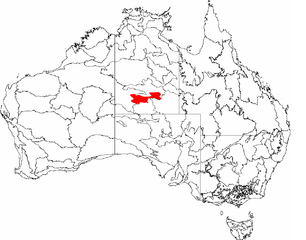
| 解説 | This is a map of the Interim Biogeographic Regionalisation of Australia (IBRA), with state boundaries overlaid. The MacDonnell Ranges region is shown in red. | ||||||||
| 日付 | |||||||||
| 原典 | It was created by the uploader. | ||||||||
| 作者 | Hesperian | ||||||||
| 許可 (ファイルの再利用) |
この作品の著作権者である私は、この作品を以下のライセンスで提供します。
あなたは上記のライセンスから、どれか一つ以上を選択できます。 |

ファイルの履歴
過去の版のファイルを表示するには、その版の日時をクリックしてください。
| 日付と時刻 | サムネイル | 寸法 | 利用者 | コメント | |
|---|---|---|---|---|---|
| 現在の版 | 2007年3月3日 (土) 04:57 | | 1,257 × 986 (83キロバイト) | Hesperian (トーク | 投稿記録) | |
| 2007年2月7日 (水) 00:45 |  | 1,149 × 948 (76キロバイト) | Hesperian (トーク | 投稿記録) | {{Information |Description=This is a map of the Interim Biogeographic Regionalisation of Australia (IBRA), with state boundaries overlaid. The '''MacDonnell Ranges''' region is shown in red. |Source=It was created by the uploader. |Date=2007-02-6 |Author= |
このファイルは上書きできません。
ファイルの使用状況
以下の 2 ページがこのファイルを使用しています:
グローバルなファイル使用状況
以下に挙げる他のウィキがこの画像を使っています:
- bg.wikipedia.org での使用状況
- ca.wikipedia.org での使用状況
- en.wikipedia.org での使用状況
- es.wikipedia.org での使用状況
- et.wikipedia.org での使用状況
- eu.wikipedia.org での使用状況
- it.wikipedia.org での使用状況
- ja.wikipedia.org での使用状況
- ky.wikipedia.org での使用状況
- ml.wikipedia.org での使用状況
- pl.wikipedia.org での使用状況
- sk.wikipedia.org での使用状況
- www.wikidata.org での使用状況