File:ICE Network.png
Ir a la navegación
Ir a la búsqueda
Tamaño de esta previsualización: 444 × 599 píxeles. Otras resoluciones: 178 × 240 píxeles | 355 × 480 píxeles | 569 × 768 píxeles | 1200 × 1620 píxeles.
Archivo original (1200 × 1620 píxeles; tamaño de archivo: 582 kB; tipo MIME: image/png)
Leyendas
Leyendas
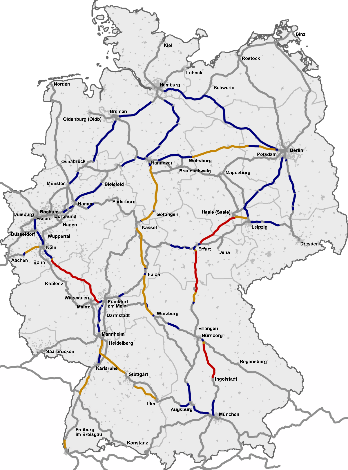
Red InterCityExpress (ICE) en Alemania

|
Esta imagen debería volverse a crear como imágenes vectoriales SVG. Esto proporciona muchas ventajas, véase Commons:Media for cleanup (en inglés) para más información. Si ya hay una versión SVG de esta imagen disponible, por favor súbala a Commons. Tras subirla, reemplace esta plantilla con la plantilla
{{vector version available|nuevo nombre de imagen.svg}} en esta imagen. |
Resumen
[editar]
Deutsch (de): Deutsches ICE-Netz
Neubaustrecken (NBS) für 300 km/h
Neubaustrecken (NBS) für mind. 250 km/h
Ausbaustrecken (ABS) für 200 km/h oder 230 km/h
Altbaustrecken, soweit möglich für 160 km/h ausgebaut
English (en): The InterCityExpress (ICE) network in Germany
High-speed lines for 300 km/h (186 mph)
High-speed lines for 250 km/h or more (155 mph and higher)
Upgraded lines for 200 km/h or 230 km/h (124 mph or 143 mph)
Conventional lines, often upgraded for 160 km/h (100 mph)
Esperanto (eo): Reto de ICE en Germanio
Altrapidaj linioj por 300 km/h (186 mph)
Altrapidaj linioj por 250 km/h aŭ pli (155 mph aŭ pli)
Plibonigitiaj linioj por 200 km/h aŭ 230 km/h (124 mph aŭ 143 mph)
Klasikaj linioj, plej ofte modernigitaj por 160 km/h (100 mph)
español (es): Red InterCityExpress (ICE) en Alemania
Líneas de alta velocidad para 300 km/h (186 mph)
Líneas de alta velocidad para 250 km/h o más (155 mph o más)
Líneas modernizadas para 200 km/h o 230 km/h (124 mph o 143 mph)
Línes convencionales, a veces modernizadas para 160 km/h (100 mph)
italiano (it): La rete degli InterCityExpress (ICE) in Germania
Linee ad alta velocità a 300 km/h
Linee ad alta velocità a 250 km/h e più
Linee modernizzate a 200 km/h o 230 km/h
Linee classiche, spesso modernizzate a 160km/h
français (fr): Réseau ICE allemand
Ligne à grande vitesse à 300 km/h
Ligne à grande vitesse à 250 km/h ou plus
Ligne classique modifiée pour aller à 200 km/h ou parfois 230 km/h
Ligne classique, parfois modifiée pour aller à 160 km/h
Nederlands (nl): Duitse ICE-net
Hogesnelheidslijnen voor 300 km/u
Hogesnelheidslijnen voor min. 250 km/u
Omgebouwde lijnen voor 200 km/h of 230 km/u
Normale lijnen, waar mogelijk omgebouwd voor 160 km/u
slovenčina (sk): Sieť ICE vlakov v Nemeckej spolkovej republike
novovybudované trate pre rýchlosť 300 km/h
novovybudované trate pre rýchlosť 250 km/h a vyššie
modernizované trate pre rýchlosti 200 km/h alebo 230km/h
klasické trate, podľa možností modernizované pre rýchlosť 160 km/h
polski (pl): Sieć pociągów ICE w Niemczech
linie dużych prędkosci do 300 km/h
linie dużych prędkosci do 250 km/h lub więcej
zmodernizowane linie do 200 km/h lub 230 km/h
linie konwencjonalne, przeważnie zmodernizowane do 160 km/h
čeština (cs): Síť vysokorychlostních vlaků ICE v Německu
Vysokorychlostní tratě pro 300 km/h
Vysokorychlostní tratě pro 250 km/h nebo více
Zmodernizované tratě do 200 km/h nebo 230 km/h
Klasické tratě, převážně zmodernizované na 160 km/h
română (ro): Reteaua InterCityExpress (ICE) in Germania
Linie de mare viteza pentru 300 km/h (186 mph)
Linie de mare viteza pentru 250 km/h sau mai mult (155 mph sau mai mult)
Linie imbunatatita pentru 200 km/h sau 230 km/h (124 mph sau 143 mph)
Linie conventionala, in multe parti imbunatatita pentru 160 km/h (100 mph)
한국어 (ko): 독일 ICE 선로망 최고속도 표
신설 구간 (최고속도 300km/h - Sprinter 열차 구간들)
신설 구간 (최고속도 250km/h 또는 그 이상)
개량구간 (최고속도 200km/h 또는 230km/h)
기존구간 (보통 최고속도 160km/h까지 견딜 수 있는 선로로 개량됨)
suomi (fi): InterCityExpress (ICE) -verkko Saksassa
Suurnopeusradat 300 km/h
Suurnopeusradat yli 250 km/h
Parannellut radat 200 km/h tai 230 km/h
Tavalliset radat, yleensä 160 km/h
русский (ru): Сеть железнодорожных путей InterCityExpress (ICE) в Германии
Высокоскоростные пути с пределом скорости в 300 км/ч
Высокоскоростные пути с пределом скорости в 250 км/ч или более
Переоборудованные пути с пределом скорости 200 или 230 км/ч
Обычные пути, улучшенные для эксплуатации с пределом скорости в 160 км/ч
中文 (zh): 城际特快列车 InterCityExpress (ICE) 在德国的铁路网
高速 300 km/h
中高速 250 km/h 或以上
中速 200 km/h 或 230 km/h
普通速度 通常为 160 km/h或以上
українська (uk): Мережа залізничних колій InterCityExpress (ICE) у Німеччині
Новозбудовані колії для швидкості до 300 км/г
Новозбудовані колії для швидкості щонайменше 250 км/г
Модернізовані колії для швидкості до 200 км/г або 230 км/г
Звичайні колії модернізовані, де можливо, для швидкості до 160 км/г
Ελληνικά (el): Το σιδηροδρομικό δίκτυο της υπερταχείας InterCityExpress (ICE) στην Γερμανία
Γραμμές υψηλών ταχυτήτων για έως 300 χλμ/ω
Γραμμές υψηλών ταχυτήτων για 250 χλμ/ω και άνω
Αναβαθμισμένες γραμμές για ταχύτητες έως 200 χλμ/ω ή έως 230 χλμ/ω
Συμβατικές γραμμές, με δυνατότητα αναβάθμισης για ταχύτητες έως 160 χλμ/ω
Source
[editar]
Based on a map from OpenGeoDB, data from DB timetables, OpenRailwayMap and a map from ice-fanpage.de and DB releases like this.
Véase también
[editar]
Véase también 
|
Licencia
[editar]
This image was generated with OpenGeoDB. The information there is placed in the public domain, images generated from OpenGeoDB are derivative works without passing the threshold of creativity, they are therefore also public domain.
| Esta imagen no es elegible para estar sujeta a derecho de autor y por tanto está en el dominio público, porque consiste enteramente en información que es de propiedad común y carece de autoría original. |
Historial del archivo
Haz clic sobre una fecha y hora para ver el archivo tal como apareció en ese momento.
| Fecha y hora | Miniatura | Dimensiones | Usuario | Comentario | |
|---|---|---|---|---|---|
| actual | 09:18 29 dic 2022 | | 1200 × 1620 (582 kB) | DerBaomeister (discusión | contribs.) | Addition of line between Osnabrück and Löhne |
| 08:48 29 dic 2022 |  | 1200 × 1620 (582 kB) | DerBaomeister (discusión | contribs.) | Addition of line between Berlin and Rostock | |
| 02:15 29 dic 2022 |  | 1200 × 1620 (579 kB) | DerBaomeister (discusión | contribs.) | Addition of two lines and Potsdam | |
| 00:59 29 dic 2022 |  | 1200 × 1620 (578 kB) | DerBaomeister (discusión | contribs.) | Second general revision of map with addition of new high-speed line between Wendlingen and Ulm | |
| 02:37 1 nov 2022 |  | 1200 × 1620 (589 kB) | DerBaomeister (discusión | contribs.) | Small addition of stop in Coburg | |
| 12:40 27 oct 2022 |  | 1200 × 1620 (589 kB) | DerBaomeister (discusión | contribs.) | Minor corrections | |
| 20:19 18 oct 2022 |  | 1200 × 1620 (589 kB) | DerBaomeister (discusión | contribs.) | Improvements around Stuttgart; removal of one line | |
| 00:17 10 oct 2022 |  | 1200 × 1620 (590 kB) | DerBaomeister (discusión | contribs.) | Some improvements | |
| 16:16 27 ago 2022 |  | 1200 × 1620 (592 kB) | DerBaomeister (discusión | contribs.) | Further extension of international ICE/ECE lines | |
| 17:34 13 ago 2022 |  | 1200 × 1620 (582 kB) | DerBaomeister (discusión | contribs.) | Extension of international ICE lines |
No puedes sobrescribir este archivo.
Usos del archivo
Las siguientes páginas usan este archivo:
- ICE
- Top 200 transport map images that should use vector graphics
- User:Chumwa/OgreBot/Potential transport maps/2016 June 1-10
- User:Chumwa/OgreBot/Potential transport maps/2016 September 21-30
- User:Chumwa/OgreBot/Potential transport maps/2017 December 1-10
- User:Chumwa/OgreBot/Potential transport maps/2017 December 11-20
- User:Chumwa/OgreBot/Public transport information/2016 June 1-10
- User:Chumwa/OgreBot/Public transport information/2016 September 21-30
- User:Chumwa/OgreBot/Public transport information/2017 December 1-10
- User:Chumwa/OgreBot/Public transport information/2017 December 11-20
- User:Chumwa/OgreBot/Public transport information/2022 August 11-20
- User:Chumwa/OgreBot/Public transport information/2022 August 21-31
- User:Chumwa/OgreBot/Public transport information/2022 December 21-31
- User:Chumwa/OgreBot/Public transport information/2022 July 11-20
- User:Chumwa/OgreBot/Public transport information/2022 July 21-31
- User:Chumwa/OgreBot/Public transport information/2022 November 1-10
- User:Chumwa/OgreBot/Public transport information/2022 October 1-10
- User:Chumwa/OgreBot/Public transport information/2022 October 11-20
- User:Chumwa/OgreBot/Public transport information/2022 October 21-31
- User:Chumwa/OgreBot/Transport Maps/2016 June 1-10
- User:Chumwa/OgreBot/Transport Maps/2016 September 21-30
- User:Chumwa/OgreBot/Transport Maps/2017 December 1-10
- User:Chumwa/OgreBot/Transport Maps/2017 December 11-20
- User:Chumwa/OgreBot/Transport Maps/2022 August 11-20
- User:Chumwa/OgreBot/Transport Maps/2022 August 21-31
- User:Chumwa/OgreBot/Transport Maps/2022 December 21-31
- User:Chumwa/OgreBot/Transport Maps/2022 July 11-20
- User:Chumwa/OgreBot/Transport Maps/2022 July 21-31
- User:Chumwa/OgreBot/Transport Maps/2022 November 1-10
- User:Chumwa/OgreBot/Transport Maps/2022 October 1-10
- User:Chumwa/OgreBot/Transport Maps/2022 October 11-20
- User:Chumwa/OgreBot/Transport Maps/2022 October 21-31
- User:Chumwa/OgreBot/Travel and communication maps/2016 June 1-10
- User:Chumwa/OgreBot/Travel and communication maps/2016 September 21-30
- User:Chumwa/OgreBot/Travel and communication maps/2017 December 1-10
- User:Chumwa/OgreBot/Travel and communication maps/2017 December 11-20
- User:Magog the Ogre/PD ineligible/2016 June 4-6
- User:Magog the Ogre/PD ineligible/2016 June 7-10
- User:Magog the Ogre/PD ineligible/2016 September 23-26
- User:Magog the Ogre/PD ineligible/2017 December 12-15
- User:Magog the Ogre/PD ineligible/2017 December 8-11
- User:MorbZ
- User:Nordlicht8/Rail Germany/2016 June 1-10
- User:Nordlicht8/Rail Germany/2022 December 21-31
- File:Germany - ICE line network, train frequencies and top speeds.svg
- File:ICE-Linien in Österreich.png
- File:ICEtracks.svg
- File:Karte IC-, EC- und ICE-Strecken Deutschland.png
Uso global del archivo
Las wikis siguientes utilizan este archivo:
- Uso en ca.wikipedia.org
- Uso en cs.wikipedia.org
- Uso en da.wikipedia.org
- Uso en de.wikipedia.org
- Uso en el.wikipedia.org
- Uso en en.wikipedia.org
- Uso en es.wikipedia.org
- Uso en fi.wikipedia.org
- Uso en fr.wikipedia.org
- Uso en fy.wikipedia.org
- Uso en hu.wikipedia.org
- Uso en it.wikipedia.org
- Uso en ja.wikipedia.org
- Uso en ko.wikipedia.org
- Uso en lad.wikipedia.org
- Uso en lb.wikipedia.org
- Uso en ms.wikipedia.org
- Uso en nl.wikipedia.org
- Uso en nn.wikipedia.org
- Uso en no.wikipedia.org
- Uso en pl.wikipedia.org
- Uso en ro.wikipedia.org
- Uso en ru.wikipedia.org
- Uso en sh.wikipedia.org
- Uso en simple.wikipedia.org
- Uso en sk.wikipedia.org
- Uso en sr.wikipedia.org
- Uso en uk.wikipedia.org
- Uso en zh.wikipedia.org