File:Iberian Peninsula antique map.jpg
跳至導覽
跳至搜尋

預覽大小:739 × 599 像素。 其他解析度:296 × 240 像素 | 592 × 480 像素 | 947 × 768 像素 | 1,263 × 1,024 像素 | 2,096 × 1,700 像素。
原始檔案 (2,096 × 1,700 像素,檔案大小:5.81 MB,MIME 類型:image/jpeg)
說明
說明
添加單行說明來描述出檔案所代表的內容
|
摘要
[編輯]
| 描述 |
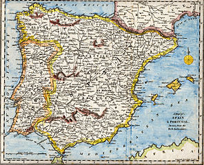
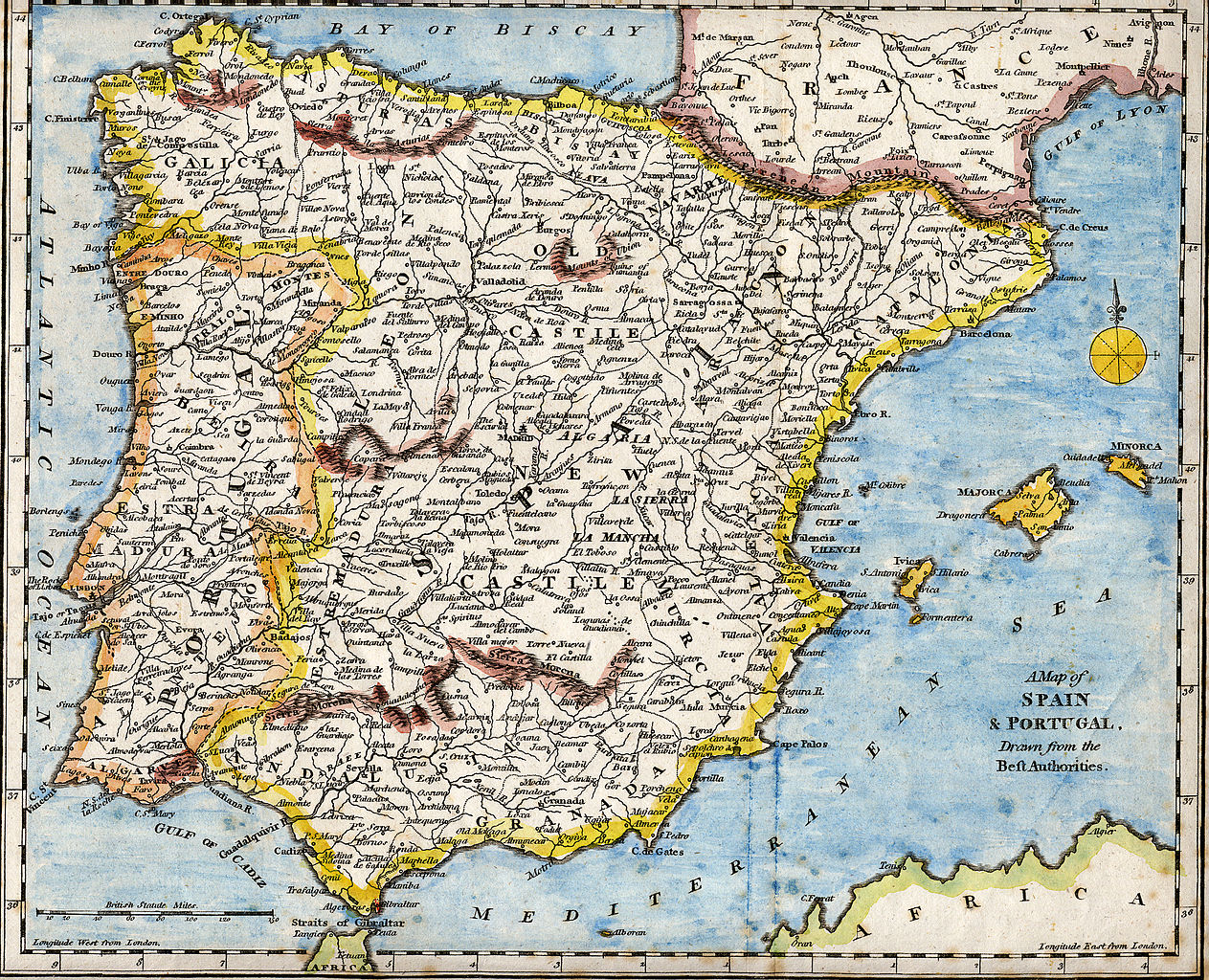
English: 18th century hand-coloured engraved map of the Iberian peninsula depicting various topographical features of the land, as published in Robert Wilkinson's General Atlas, circa 1794. (Volume 2., page 666.)
Titl'd A Map of Spain & Portugal, Drawn from the Beſt Authorities Español: Mapa del siglo XVIII grabado al cobre e iluminado a mano, representando varias características topográficas de la Península Ibérica. Publicado en el atlas general de Robert Wilkinson (volumen 2., página 666.)
Português: Mapa do século XVIII gravado em cobre e iluminado a mão, representando várias características topográficas da Península Ibérica. Publicado no atlas geral de Robert Wilkinson (volume 2., página 666.)
Català: Mapa del segle XVIII grabat al coure i il·luminat a mà, representant diverses característiques topogràfiques de la Península Ibèrica. Publicat en l'atles general de Robert Walkinson (volum 2., pàgina 666) |
|||||||||||||||||||
| 日期 | circa 1794 | |||||||||||||||||||
| 來源 | Scanned from my personal collection. (scanned by User:RedCoat) | |||||||||||||||||||
| 作者 |
|
|||||||||||||||||||
| 圖中地點 | [published at] No. 58 Cornhill London, England | |||||||||||||||||||
授權條款
[編輯]
|
本作品在其來源國以及其他著作權期限是作者逝世後70年或以下的國家與地區屬於公有領域。 | |
| 此作品無已知的著作權限制,亦不受所有相關和鄰接的權利限制。 | |
檔案歷史
點選日期/時間以檢視該時間的檔案版本。
| 日期/時間 | 縮圖 | 尺寸 | 使用者 | 備註 | |
|---|---|---|---|---|---|
| 目前 | 2007年10月28日 (日) 17:01 | | 2,096 × 1,700(5.81 MB) | RedCoat(留言 | 貢獻) | {{Information | Description ={{en|18th century hand-coloured engraved map of the Iberian peninsula depicting various topographical features of the land, as published in Robert Wilkinson's ''General Atlas'', circa 1794. |
無法覆蓋此檔案。
檔案用途
沒有使用此檔案的頁面。
全域檔案使用狀況
以下其他 wiki 使用了這個檔案:
- ar.wikipedia.org 的使用狀況
- ast.wikipedia.org 的使用狀況
- azb.wikipedia.org 的使用狀況
- ba.wikipedia.org 的使用狀況
- bg.wikipedia.org 的使用狀況
- ca.wikipedia.org 的使用狀況
- de.wikipedia.org 的使用狀況
- en.wikipedia.org 的使用狀況
- History of Spain
- Portal:Spain
- Portal:Portugal
- Portal:Portugal/Recognized content
- Portal:European Union/Selected picture
- Portal:Maps/Selected picture
- Loa (Spanish play)
- Wikipedia:Featured pictures thumbs/07
- Wikipedia:WikiProject Portugal/FAC
- Portal:European Union/Selected picture/5
- Wikipedia:WikiProject Gibraltar
- Wikipedia:Featured picture candidates/July-2007
- Wikipedia:Wikipedia Signpost/2007-07-23/Features and admins
- Wikipedia:Featured picture candidates/Iberian Peninsula antique map.jpg
- Wikipedia:Wikipedia Signpost/2007-07-23/SPV
- Robert Wilkinson (cartographer)
- User talk:RedCoat10/Archive 2
- Portal:Maps/Selected picture/9
- Wikipedia:Picture of the day/November 2007
- Template:POTD/2007-11-11
- User talk:RedCoat10/Archive 3
- Portal:Spain/Exemplary content
- Wikipedia:Featured pictures/Diagrams, drawings, and maps/Maps
- Wikipedia:WikiProject Spain/Recognized content
- Iberian ship development, 1400–1600
- Portal:Geography/Selected picture
- Wikipedia:WikiProject Portugal/Recognized content
- Wikipedia:Wikipedia Signpost/Single/2007-07-23
- es.wikipedia.org 的使用狀況
- eu.wikipedia.org 的使用狀況
- fa.wikipedia.org 的使用狀況
- gl.wikipedia.org 的使用狀況
- it.wikipedia.org 的使用狀況
- mg.wikipedia.org 的使用狀況
- ml.wikipedia.org 的使用狀況
- ms.wikipedia.org 的使用狀況
- mwl.wikipedia.org 的使用狀況
檢視此檔案的更多全域使用狀況。