File:India disputed areas map.svg

Fichier d’origine (Fichier SVG, nominalement de 1 639 × 1 852 pixels, taille : 978 kio)
Légendes
Légendes
Description[modifier]
| Titre |
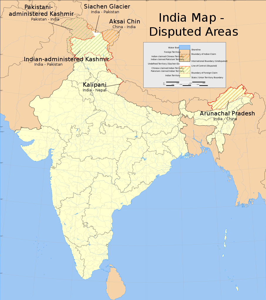
India map disputed areas |
| Description |
English: Map showing disputed areas of India. See also File:India Pakistan China Disputed Areas Map.png. |
| Légende de la carte |
 |
| Date | |
| Source |
Travail personnel |
| Créé par | |
| Autorisation (Réutilisation de ce fichier) |
|
| Données géotemporelles | |
| Date représentée | 2e moitié de XXe siècle et XXIe siècle |
| Système de coordonnées | conic |
| Géoréférencement | Si c'est inapproprié, définissez warp_status = skip pour masquer. |
| Données d'archives | |
| Notes | Part of WikiProject India Maps |
| SVG information | Le code de ce fichier SVG n'est pas valide en raison de 4 erreurs. Cette carte W3C-invalide a été créée avec Adobe Illustrator |
Notes[modifier]
Depiction of India's borders[modifier]
- The territorial boundaries of India are shown as per the actual ground situation in accordance with international practices followed by the United Nations ([1], [2]) and the National Geographic Society ([3], [4])
- This map is meant to be for illustrative purpose only and is not authenticated by official government sources. Please check the list of sources and references used to create the map for a measure of accuracy and verifiability.
- The usage of these maps in India, Pakistan and China are governed by different laws that restrict depictions of boundaries other than what is officially recognized by the state. Please check local laws and modify the map accordingly before use.
Explanation of disputed boundaries[modifier]


- Boundary of Indian claim : The territory India claims is legally theirs, but the claim is disputed by China and Pakistan.
- Line of Control/Line of Conflict : The de facto administrative boundary recognised by the international community. This UN ceasefire line is considered as a temporary solution to an ongoing conflict since the departure of the British Raj.
Borders of disputed regions[modifier]
The depicted extent of the former territory of the British Indian Empire, succeeded by Republic of India, may not be accepted by few countries as legal due to ongoing border disputes:
- The northern Himalayan region of the disputed territory Indian-administered Kashmir is claimed by India including (Pakistan-administered Kashmir) and the Chinese-occupied territory of (Ladakh plateau). Since 1972, it is divided between all three countries. See also Line of Control and Line of Actual Control.
- Siachen glacier (shown white) is an actively contested region between India and Pakistan. Since 1984, the region is under Indian control.
- The northeastern territory of Arunachal Pradesh is almost entirely claimed by China as part of its Tibetan territory.
- Minor areas of eastern Kashmir's Ladakh division, Himachal Pradesh and Uttarakhand on the Chinese frontier are claimed by China. These areas are under Indian control.
- A small area of Uttarakhand adjoining the Nepal border along the Sarda river is disputed between the two countries.
For a detailed map of all disputed regions in South Asia, see Image:India disputed areas map.svg
Internal borders[modifier]
The borders of the state of Meghalaya, Assam and Arunachal Pradesh are shown as interpreted from the North-Eastern Areas (Reorganisation) Act, 1971, but has yet to be verified.
Territorial waters[modifier]
The limit of the territorial waters of India extends to twelve nautical miles measured from the appropriate baseline. See this for more information.
Conditions d’utilisation[modifier]
- Vous êtes libre :
- de partager – de copier, distribuer et transmettre cette œuvre
- d’adapter – de modifier cette œuvre
- Sous les conditions suivantes :
- paternité – Vous devez donner les informations appropriées concernant l'auteur, fournir un lien vers la licence et indiquer si des modifications ont été faites. Vous pouvez faire cela par tout moyen raisonnable, mais en aucune façon suggérant que l’auteur vous soutient ou approuve l’utilisation que vous en faites.
- partage à l’identique – Si vous modifiez, transformez, ou vous basez sur cette œuvre, vous devez distribuer votre contribution sous la même licence ou une licence compatible avec celle de l’original.
Historique du fichier
Cliquer sur une date et heure pour voir le fichier tel qu'il était à ce moment-là.
| Date et heure | Vignette | Dimensions | Utilisateur | Commentaire | |
|---|---|---|---|---|---|
| actuel | 10 juin 2020 à 11:51 | | 1 639 × 1 852 (978 kio) | Uanfala (d | contributions) | Quickly change the wording in Kashmir for neutrality and consistency |
| 31 juillet 2006 à 12:55 |  | 1 639 × 1 852 (978 kio) | Planemad (d | contributions) | {{WikiProject_India_Maps |Title=India map disputed areas |Description=Map showing disputed areas of India. |Source=. |Date=July 31 2006 |Author=w:user:Planemad |Thumbdir=a/ab }} |
Vous ne pouvez pas remplacer ce fichier.
Utilisations locales du fichier
Plus de 100 pages utilisent ce fichier. La liste suivante affiche seulement les 100 premières pages qui utilisent ce fichier. Une liste complète est disponible.
- Atlas of India
- File:India Andhra Pradesh locator map (1956-2014).svg
- File:India Arunachal Pradesh locator map.svg
- File:India Assam locator map.svg
- File:India Awadh locator map.svg
- File:India Bagelkhand locator map.svg
- File:India Bihar locator map.svg
- File:India Bundelkhand locator map.svg
- File:India Carnatic locator map.svg
- File:India Central Travancore locator map.svg
- File:India Chhattisgarh locator map.svg
- File:India Chola Nadu locator map.svg
- File:India Circar locator map.svg
- File:India Coastal Andhra locator map.svg
- File:India Coromandel Coast locator map.svg
- File:India Delhi locator map.svg
- File:India Dhundhar locator map.svg
- File:India Goa locator map.svg
- File:India Godwar locator map.svg
- File:India Gujarat locator map.svg
- File:India Hadoti locator map.svg
- File:India Harit Pradesh locator map.svg
- File:India Haryana locator map.svg
- File:India Himachal Pradesh locator map.svg
- File:India Jammu and Kashmir locator map.svg
- File:India Jharkhand locator map.svg
- File:India Karnataka locator map.svg
- File:India Kerala locator map.svg
- File:India Khandesh locator map.svg
- File:India Kongu Nadu locator map.svg
- File:India Konkan locator map.svg
- File:India Kutch locator map.svg
- File:India Lakshadweep locator map.svg
- File:India Madhya Pradesh locator map.svg
- File:India Maharashtra locator map.svg
- File:India Malabar Coast locator map.svg
- File:India Malabar locator map.svg
- File:India Manipur locator map.svg
- File:India Marathwada locator map.svg
- File:India Marwar locator map.svg
- File:India Meghalaya locator map.svg
- File:India Mewar locator map.svg
- File:India Mewat locator map.svg
- File:India Mizoram locator map.svg
- File:India Nagaland locator map.svg
- File:India Naxal affected districts map.svg
- File:India Orissa locator map.svg
- File:India Pandya Nadu locator map.svg
- File:India Punjab locator map.svg
- File:India Purvanchal locator map.svg
- File:India Rajasthan locator map.svg
- File:India Rayalaseema locator map.svg
- File:India Saurashtra locator map.svg
- File:India Shekhawati locator map.svg
- File:India Sikkim locator map.svg
- File:India Tamil Nadu locator map.svg
- File:India Telangana locator map.svg
- File:India Thar locator map.svg
- File:India Travancore locator map.svg
- File:India Tripura locator map.svg
- File:India Uttar Pradesh locator map.svg
- File:India Uttarakhand locator map.svg
- File:India Uttaranchal locator map.svg
- File:India Vagad locator map.svg
- File:India Venad locator map.svg
- File:India Vidarbha locator map.svg
- File:India West Bengal locator map.svg
- File:India annual rainfall map.svg
- File:India annual rainfall map en.svg
- File:India average annual temperature map en.svg
- File:India climatic disaster risk map en.svg
- File:India climatic zone map en.svg
- File:India decadal growth rate map.svg
- File:India decadal growth rate map en.svg
- File:India disputed areas map.svg
- File:India earthquake zone map.svg
- File:India earthquake zone map en.svg
- File:India flood zone map.svg
- File:India literacy rate map.svg
- File:India literacy rate map en.svg
- File:India map blank.svg
- File:India map en.svg
- File:India physical map.svg
- File:India population density map.svg
- File:India population density map en.svg
- File:India rivers and lakes map.svg
- File:India roadway map.svg
- File:India roadway map with population density.svg
- File:India sex ratio map.svg
- File:India sex ratio map en.svg
- File:India simplified roadway map.svg
- File:India southwest summer monsoon onset map en.svg
- File:India states and union territories map.svg
- File:India states and union territories numbered map.svg
- File:India topographical roadway map.svg
- File:India wind zone map.svg
- File:India wind zone map en.svg
- File:Indian Kadamba Empire map.svg
- File:Indian Kanauj triangle map.svg
- File:Indian Mysore Kingdom 1784 map.svg
.svg)
Voir plus de liens vers ce fichier.
Utilisations du fichier sur d’autres wikis
Les autres wikis suivants utilisent ce fichier :
- Utilisation sur en.wikipedia.org
- Utilisation sur es.wikipedia.org
- Utilisation sur fi.wikipedia.org
- Utilisation sur fr.wikipedia.org
- Utilisation sur ja.wikipedia.org
- Utilisation sur kn.wikipedia.org
- Utilisation sur ml.wikipedia.org
- Utilisation sur mr.wikipedia.org
- Utilisation sur or.wikipedia.org
- Utilisation sur pa.wikipedia.org
- Utilisation sur pnb.wikipedia.org
- Utilisation sur ru.wikinews.org
- Utilisation sur sh.wikipedia.org
- Utilisation sur sr.wikipedia.org
- Utilisation sur sv.wikipedia.org
- Utilisation sur ta.wikipedia.org
- Utilisation sur te.wikipedia.org
- Utilisation sur ur.wikipedia.org
- Utilisation sur vi.wikipedia.org
- Utilisation sur www.wikidata.org
- Utilisation sur zh.wikipedia.org