File:Indian states affected by July 2012 power cuts.svg
跳至導覽
跳至搜尋

此 SVG 檔案的 PNG 預覽的大小:530 × 599 像素。 其他解析度:212 × 240 像素 | 425 × 480 像素 | 680 × 768 像素 | 906 × 1,024 像素 | 1,812 × 2,048 像素 | 1,639 × 1,852 像素。
原始檔案 (SVG 檔案,表面大小:1,639 × 1,852 像素,檔案大小:302 KB)
說明
說明
添加單行說明來描述出檔案所代表的內容
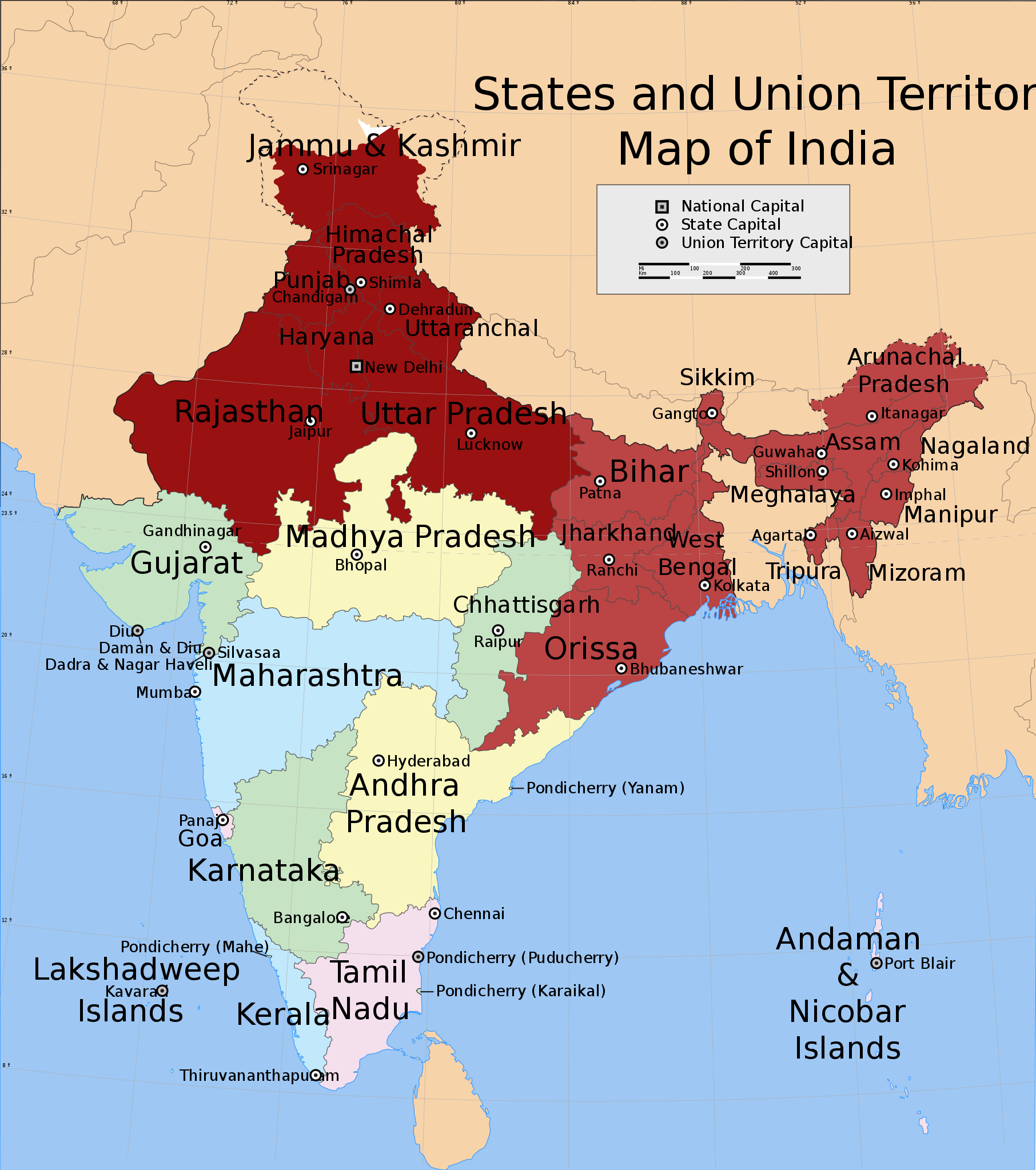
Northern and Eastern regions power blackouts in 2012
摘要
[編輯]
| 描述 |
English: Shows in dark red the states listed at the time of creation: Jammu and Kashmir, Himachal Pradesh, Punjab, Haryana, Delhi, Rajasthan, Uttar Pradesh, Bihar, West Bengal, Orissa, Jharkhand, Sikkim, Assam, Meghalaya, Tripura, Nagaland, Manipur, Mizoram and Arunachal Pradesh.
Derived from India_states_and_union_territories_map.svg by changing the fill colour for those states. |
| 日期 | Not known. Modified 2012年七月31日 |
| 來源 | File:India_states_and_union_territories_map.svg |
| 作者 | Whoever uploaded File:India_states_and_union_territories_map.svg to English Wikipedia |
| 授權許可 (重用此檔案) |
http://en.wikipedia.org |
授權條款
[編輯]
此檔案採用共享創意 姓名標示-相同方式分享 1.0 通用版授權條款。
- 您可以自由:
- 分享 – 複製、發佈和傳播本作品
- 重新修改 – 創作演繹作品
- 惟需遵照下列條件:
- 姓名標示 – 您必須指名出正確的製作者,和提供授權條款的連結,以及表示是否有對內容上做出變更。您可以用任何合理的方式來行動,但不得以任何方式表明授權條款是對您許可或是由您所使用。
- 相同方式分享 – If you alter, transform, or build upon this work, you must distribute the resulting work under the same license as the original.
原始上傳日誌
[編輯]
Transferred from en.wikipedia to Commons.
The original description page was here. All following user names refer to en.wikipedia.
- 2012-07-31 20:55 Maproom 1639×1852× (309753 bytes) Added Uttaranchal to affected area, removed Assam and states south and east of it.
- 2012-07-31 17:29 Maproom 1639×1852× (309753 bytes) Uploading a file from a free published source using [[Wikipedia:File_Upload_Wizard|File Upload Wizard]]
The original description page was here. All following user names refer to en.wikipedia.
- 2012-08-01 15:07 Maproom 1639×1852× (309753 bytes) altered the status of (Bihar, West Bengal, Jharkhand, Orissa, Chhattisgarh) to 2nd-day only.
- 2012-08-01 08:12 Maproom 1639×1852× (309753 bytes) re-added the north-eastern states, in a lighter colour
- 2012-08-01 08:09 Maproom 1639×1852× (309753 bytes) re-added the north-eastern states, in a lighter colour
- 2012-07-31 20:55 Maproom 1639×1852× (309753 bytes) Added Uttaranchal to affected area, removed Assam and states south and east of it.
- 2012-07-31 17:29 Maproom 1639×1852× (309753 bytes) Uploading a file from a free published source using [[Wikipedia:File_Upload_Wizard|File Upload Wizard]]
檔案歷史
點選日期/時間以檢視該時間的檔案版本。
| 日期/時間 | 縮圖 | 尺寸 | 用戶 | 備註 | |
|---|---|---|---|---|---|
| 目前 | 2012年8月9日 (四) 15:17 | | 1,639 × 1,852(302 KB) | Maproom(對話 | 貢獻) | un-marked Chhattisgarh, in accordance with request at http://en.wikipedia.org/wiki/Wikipedia:WikiProject_Maps/Requested_and_orphan_maps |
| 2012年8月1日 (三) 17:34 |  | 1,639 × 1,852(302 KB) | OgreBot(對話 | 貢獻) | (BOT): Uploading old version of file from en.wikipedia; originally uploaded on 2012-08-01 15:07:18 by Maproom | |
| 2012年8月1日 (三) 17:33 |  | 1,639 × 1,852(302 KB) | OgreBot(對話 | 貢獻) | (BOT): Uploading old version of file from en.wikipedia; originally uploaded on 2012-08-01 08:09:17 by Maproom | |
| 2012年8月1日 (三) 17:33 |  | 1,639 × 1,852(302 KB) | OgreBot(對話 | 貢獻) | (BOT): Uploading old version of file from en.wikipedia; originally uploaded on 2012-07-31 17:29:42 by Maproom | |
| 2012年8月1日 (三) 04:36 |  | 1,639 × 1,852(302 KB) | Makecat(對話 | 貢獻) | {{Information |Description={{en|Shows in dark red the states listed at the time of creation: Jammu and Kashmir, Himachal Pradesh, Punjab, Haryana, Delhi, Rajasthan, Uttar Pradesh, Bihar, West Bengal, Orissa, Jharkhand, Sikkim, Assam, Meghalaya, Tripura... |
無法覆蓋此檔案。
檔案用途
沒有使用此檔案的頁面。
全域檔案使用狀況
以下其他 wiki 使用了這個檔案:
- af.wikipedia.org 的使用狀況
- ar.wikipedia.org 的使用狀況
- en.wikipedia.org 的使用狀況
- es.wikipedia.org 的使用狀況
- fr.wikipedia.org 的使用狀況
- he.wikipedia.org 的使用狀況
- ko.wikipedia.org 的使用狀況
- lv.wikipedia.org 的使用狀況
- pt.wikipedia.org 的使用狀況
- ru.wikipedia.org 的使用狀況
- ta.wikipedia.org 的使用狀況
- th.wikipedia.org 的使用狀況
- vi.wikipedia.org 的使用狀況
- zh.wikipedia.org 的使用狀況