File:Indochina map 1886.jpg
পরিভ্রমণে চলুন
অনুসন্ধানে চলুন

এই প্রাকদর্শনের আকার: ৪৬১ × ৫৯৯ পিক্সেল। অন্যান্য আকারসমূহ: ১৮৪ × ২৪০ পিক্সেল | ৩৬৯ × ৪৮০ পিক্সেল | ৫৯১ × ৭৬৮ পিক্সেল | ৭৮৮ × ১,০২৪ পিক্সেল | ১,৬২৬ × ২,১১৪ পিক্সেল।
মূল ফাইল (১,৬২৬ × ২,১১৪ পিক্সেল, ফাইলের আকার: ৫৩৩ কিলোবাইট, এমআইএমই ধরন: image/jpeg)
ক্যাপশনসমূহ
ক্যাপশন
এই ফাইলটি কী উপস্থাপন করছে তার এক লাইন ব্যাখ্যা যোগ করুন
super map
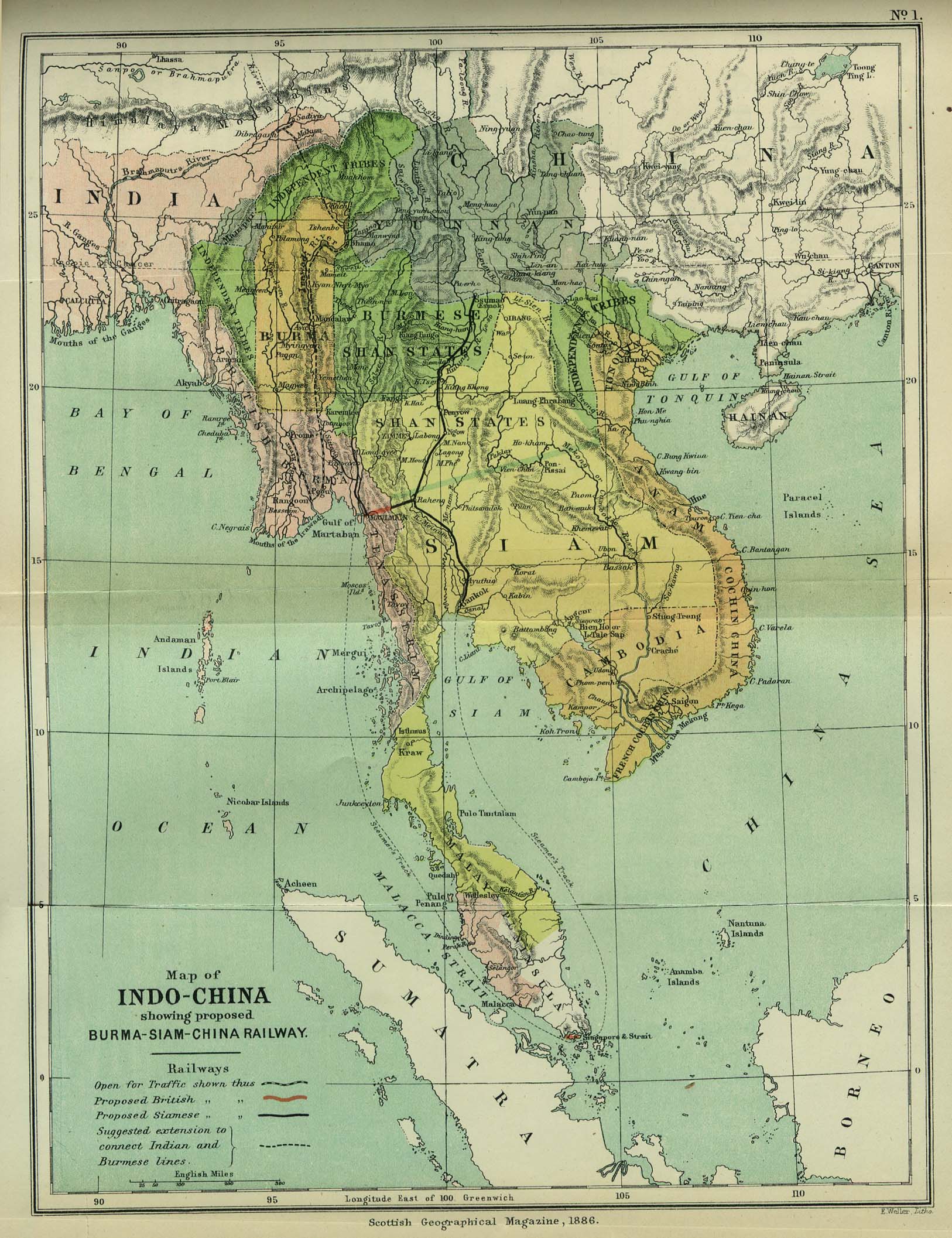
| বিবরণ | Map of Indochina | ||||
| তারিখ | |||||
| উৎস | http://www.lib.utexas.edu/maps/cambodia.html (http://www.lib.utexas.edu/maps/historical/indo_china_1886.jpg); Scottish Geographical Magazine (Volume II) | ||||
| লেখক | Scottish Geographical Magazine and edited by Hugh A. Webster and Arthur Silva White | ||||
| অনুমতি (এ ফাইলের পুনঃব্যবহার) |
|
||||
| অন্যান্য সংস্করণ | File:IndoChina1886.jpg | ||||
ফাইলের ইতিহাস
যেকোনো তারিখ/সময়ে ক্লিক করে দেখুন ফাইলটি তখন কী অবস্থায় ছিল।
| তারিখ/সময় | সংক্ষেপচিত্র | মাত্রা | ব্যবহারকারী | মন্তব্য | |
|---|---|---|---|---|---|
| বর্তমান | ০২:৫৬, ২ মে ২০০৮ | | ১,৬২৬ × ২,১১৪ (৫৩৩ কিলোবাইট) | Calliopejen1 (আলোচনা | অবদান) | {{Information |Description=Map of French Indochina |Source=http://www.lib.utexas.edu/maps/cambodia.html (http://www.lib.utexas.edu/maps/historical/indo_china_1886.jpg) |Date=1886 |Author=Scottish Geographical Magazine |Permission={{PD-old}} |other_version |
আপনি এই ফাইলটি প্রতিস্থাপন করতে পারবেন না।
ফাইলের ব্যবহার
এই ফাইল ব্যবহার করে এমন কোনো পাতা নেই।
ফাইলের বৈশ্বিক ব্যবহার
নিচের অন্যান্য উইকিগুলো এই ফাইলটি ব্যবহার করে:
- bcl.wikipedia.org-এ ব্যবহার
- el.wikipedia.org-এ ব্যবহার
- en.wikipedia.org-এ ব্যবহার
- en.wikiversity.org-এ ব্যবহার
- fi.wikipedia.org-এ ব্যবহার
- got.wikipedia.org-এ ব্যবহার
- kn.wikipedia.org-এ ব্যবহার
- ms.wikipedia.org-এ ব্যবহার
- pa.wikipedia.org-এ ব্যবহার
- sl.wikipedia.org-এ ব্যবহার
- uz.wikipedia.org-এ ব্যবহার