File:Influenza Seasonal Risk Areas.svg
跳至導覽
跳至搜尋

此 SVG 檔案的 PNG 預覽的大小:800 × 411 像素。 其他解析度:320 × 164 像素 | 640 × 329 像素 | 1,024 × 526 像素 | 1,280 × 657 像素 | 2,560 × 1,314 像素 | 863 × 443 像素。
原始檔案 (SVG 檔案,表面大小:863 × 443 像素,檔案大小:3.17 MB)
說明
說明
添加單行說明來描述出檔案所代表的內容
摘要
[編輯]
| 描述 |
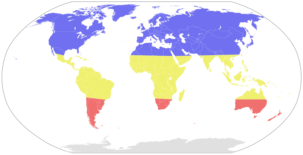
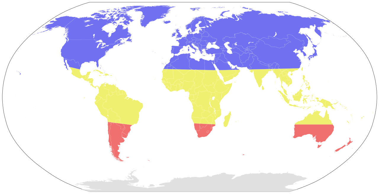
A map showing the seasonal risk areas for influenza, as indicated in the TravelWise™ pamphlet
|
|
| 日期 | (UTC) | |
| 來源 | ||
| 作者 |
|
授權條款
[編輯]
此檔案採用共享創意 姓名標示-相同方式分享 3.0 未在地化版本授權條款。
- 您可以自由:
- 分享 – 複製、發佈和傳播本作品
- 重新修改 – 創作演繹作品
- 惟需遵照下列條件:
- 姓名標示 – 您必須指名出正確的製作者,和提供授權條款的連結,以及表示是否有對內容上做出變更。您可以用任何合理的方式來行動,但不得以任何方式表明授權條款是對您許可或是由您所使用。
- 相同方式分享 – 如果您利用本素材進行再混合、轉換或創作,您必須基於如同原先的相同或兼容的條款,來分布您的貢獻成品。
原始上傳日誌
[編輯]
This image is a derivative work of the following images:
- File:BlankMap-World6.svg licensed with PD-self
- 2011-08-27T00:51:14Z Anomie 863x443 (1612580 Bytes) South Sudan has been assigned code SS, so use that code.
- 2011-07-30T18:04:36Z Lokal Profil 863x443 (1612578 Bytes) Minor circle related changes and remove the legacy pentagram
- 2011-07-08T23:26:24Z NuclearVacuum 863x443 (1613386 Bytes) South Sudan is free!! Hooray
- 2011-07-04T20:41:30Z NuclearVacuum 863x443 (1615589 Bytes) Restored to previous version, as SS isn't independent yet. But the code is now ready and waiting
- 2011-07-04T20:40:06Z NuclearVacuum 863x443 (1613386 Bytes) Separated South Sudan from (North) Sudan in preparation for SS independence on July 9, 2011.
- 2011-06-27T15:15:14Z Canuckguy 863x443 (1615589 Bytes) restored PR, set id labels for West Bank and Gaza
- 2011-04-01T14:09:57Z NuclearVacuum 863x443 (1614917 Bytes) Mayotte is now a department of France
- 2011-02-17T14:31:36Z NuclearVacuum 863x443 (1614903 Bytes) minor fixes
- 2011-02-13T01:43:20Z Canuckguy 863x443 (1632654 Bytes) minor fix
- 2011-01-22T20:16:24Z NuclearVacuum 863x443 (1614900 Bytes) added lakes
- 2011-01-22T20:12:02Z NuclearVacuum 863x443 (1632622 Bytes) ...
- 2011-01-22T20:08:04Z NuclearVacuum 863x443 (1632651 Bytes) Reverted to version as of 18:31, 17 January 2011
- 2011-01-22T20:07:39Z NuclearVacuum 1173x937 (334238 Bytes) just testing something
- 2011-01-17T18:31:33Z NuclearVacuum 863x443 (1632651 Bytes) minor fix of Sudan
- 2011-01-17T18:26:18Z NuclearVacuum 863x443 (1632651 Bytes) minor fix
- 2011-01-17T18:17:24Z NuclearVacuum 863x443 (1632633 Bytes) clean code
- 2011-01-17T18:12:07Z NuclearVacuum 863x443 (1632625 Bytes) added new class of circles, added Southern Sudan as a region within Sudan.
- 2011-01-15T00:06:15Z NuclearVacuum 863x443 (1631574 Bytes) minor fix
- 2011-01-14T23:51:44Z NuclearVacuum 863x443 (1631571 Bytes) added missing regions of the European Union
- 2011-01-13T14:26:50Z NuclearVacuum 863x443 (1631559 Bytes) minor fix
- 2011-01-13T14:17:57Z NuclearVacuum 863x443 (1631550 Bytes) added the BES Islands to the Netherladns
- 2011-01-07T21:02:08Z NuclearVacuum 863x443 (1631333 Bytes) minor fix
- 2011-01-07T20:55:32Z NuclearVacuum 863x443 (1631333 Bytes) corrected code for the circles
- 2011-01-06T16:44:29Z NuclearVacuum 863x443 (1208206 Bytes) removed all but 5px of whitespace, see talk page
- 2011-01-03T14:03:40Z NuclearVacuum 854x433 (1208195 Bytes) Curaçao and Sint Maarten have been given codes
- 2011-01-02T03:21:03Z Tomchen1989 854x433 (1205379 Bytes) compromised for the bug
- 2010-12-28T01:58:24Z Kintetsubuffalo 853x433 (1205378 Bytes) what are you talking about? nothing is cut off or squished
- 2010-12-28T00:28:42Z NuclearVacuum 940x477 (1631321 Bytes) Reverted to version as of 16:43, 27 October 2010
- 2010-12-19T20:10:58Z Tomchen1989 853x433 (1205378 Bytes) stroke-width of coast
- 2010-12-19T08:51:57Z Tomchen1989 853x433 (1205378 Bytes) minor change
- 2010-12-16T16:14:47Z Tomchen1989 853x433 (1205378 Bytes) radius of the circles changed
- 2010-12-14T22:57:20Z Tomchen1989 853x433 (1208461 Bytes) small fixed
- 2010-12-14T22:36:00Z Tomchen1989 853x433 (1208830 Bytes) had outside whitespace removed; cleaned the code; used tab indent
- 2010-10-27T16:43:23Z NuclearVacuum 940x477 (1631321 Bytes) fixed as part of discussion
- 2010-10-24T03:54:05Z NuclearVacuum 940x477 (1630960 Bytes) I fixed the code so it is valid
- 2010-10-10T22:06:16Z Canuckguy 940x477 (1630991 Bytes) Reverted to version as of 02:01, 18 September 2010 (Neth. Antilles removed, Sint Maarten and Curacao added, Bonaire part of "nl")
- 2010-09-18T02:01:50Z Canuckguy 940x477 (1630802 Bytes) Reverted to version as of 01:03, 9 July 2010. New version to be used October 10, 2010
- 2010-09-18T02:01:03Z Canuckguy 940x477 (1630991 Bytes) version with Sint Maarten and Curacao added, Bonaire as part of Netherlands, and Netherlands Antilles removed. To be used starting October 10, 2010
- 2010-07-09T01:03:28Z NuclearVacuum 940x477 (1630802 Bytes) after thinking about it, I think "aa" is better for the ocean than "zz"
- 2010-07-07T21:49:57Z NuclearVacuum 940x477 (1630805 Bytes) Reverted to version as of 20:25, 7 July 2010
- 2010-07-07T21:49:26Z NuclearVacuum 940x477 (1629207 Bytes) Reverted to version as of 16:45, 25 June 2010
- 2010-07-07T21:48:28Z NuclearVacuum 940x477 (1630623 Bytes) Reverted to version as of 16:51, 29 June 2010 checking
- 2010-07-07T21:47:19Z NuclearVacuum 940x477 (1630506 Bytes) Reverted to version as of 14:49, 1 July 2010 checking something
- 2010-07-07T20:25:43Z NuclearVacuum 940x477 (1630805 Bytes) added marker for Swaziland
- 2010-07-07T19:43:09Z NuclearVacuum 940x477 (1630656 Bytes) added the European Union
- 2010-07-01T14:49:16Z NuclearVacuum 940x477 (1630506 Bytes) minor mistake
- 2010-07-01T14:47:13Z NuclearVacuum 940x477 (1630506 Bytes) Created code for the French Southern and Antarctic Lands.
- 2010-06-29T16:51:08Z NuclearVacuum 940x477 (1630623 Bytes) minor code cleanup
- 2010-06-28T22:28:48Z NuclearVacuum 940x477 (1630576 Bytes) new version taking into account the unrecognized nations and using user-assigned code.
- 2010-06-28T20:16:10Z NuclearVacuum 940x477 (1630640 Bytes) added separate class for unrecognized nations, minor cleanup
Uploaded with derivativeFX
檔案歷史
點選日期/時間以檢視該時間的檔案版本。
| 日期/時間 | 縮圖 | 尺寸 | 用戶 | 備註 | |
|---|---|---|---|---|---|
| 目前 | 2011年12月10日 (六) 02:57 | | 863 × 443(3.17 MB) | Ninjatacoshell(對話 | 貢獻) | == {{int:filedesc}} == {{Information |Description=A map showing the seasonal risk areas for influenza, as indicated in [http://www.northeastinfectiousdiseases.org/resources/MapsTearPad.pdf the TravelWise™ pamphlet] <br> Key: <br> <table border="0" cells |
無法覆蓋此檔案。
檔案用途
下列頁面有用到此檔案:
全域檔案使用狀況
以下其他 wiki 使用了這個檔案:
- af.wikipedia.org 的使用狀況
- ar.wikipedia.org 的使用狀況
- da.wikipedia.org 的使用狀況
- de.wikipedia.org 的使用狀況
- en.wikipedia.org 的使用狀況
- hu.wikipedia.org 的使用狀況
- hu.wikibooks.org 的使用狀況
- ja.wikipedia.org 的使用狀況
- kab.wikipedia.org 的使用狀況
- ml.wikipedia.org 的使用狀況
- or.wikipedia.org 的使用狀況
- pt.wikipedia.org 的使用狀況
- sl.wikipedia.org 的使用狀況
- th.wikipedia.org 的使用狀況
- uk.wikipedia.org 的使用狀況
- zh.wikipedia.org 的使用狀況