File:Inner german border herrnburg.jpg
跳至導覽
跳至搜尋
預覽大小:800 × 379 像素。 其他解析度:320 × 151 像素 | 640 × 303 像素 | 1,456 × 689 像素。
原始檔案 (1,456 × 689 像素,檔案大小:474 KB,MIME 類型:image/jpeg)
說明
說明
添加單行說明來描述出檔案所代表的內容
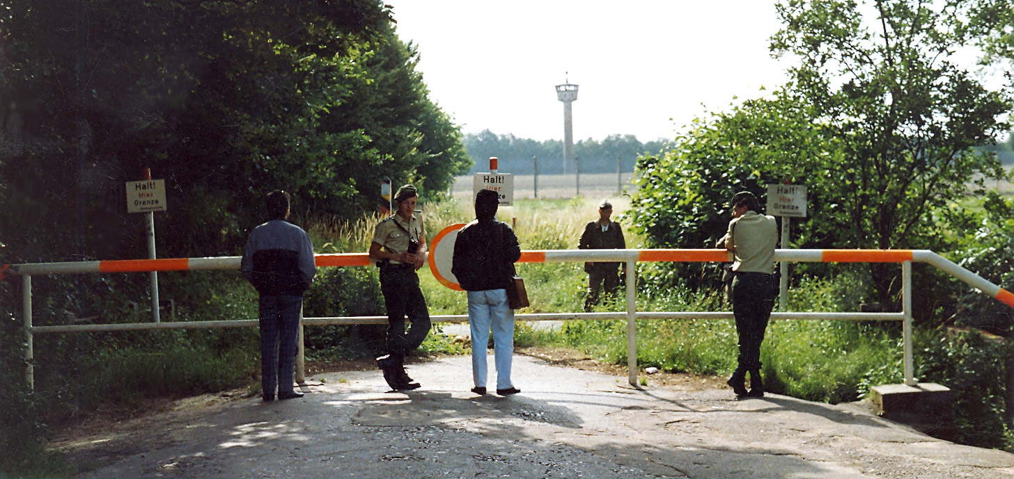
Inner German border in Ludersdorf from the West Germany's site in 1989. In the foreground we can see two soldiers of western Bundesgrenzschutz, and in the background there is seen eastern Grenztruppen soldier.
摘要
[編輯]
| 描述 |
English: (Original description by author) Lübeck remained part of Schleswig-Holstein after the war and was situated directly at the inner German border during the division of Germany into two rival states during the Cold War period. South of the city the border followed the path of the river Wakenitz that separated both countries by less than 10 m in many parts. The northernmost border crossing was in Lübeck's district of Schlutup. My historical picture here shows the former border between Lübeck and "German Democratic Republic" with the little village Herrnburg in Mecklenburg. Behind the border barrier we can see an East German border-soldier of the "National Peoples' Army", and behind him one of the several watch towers to guard the border against those attempting to escape. On this side of the border are two officers of the West German Frontier Police (Bundesgrenzschutz), today called Federal Police (Bundespolizei). |
| 日期 | |
| 來源 | https://www.flickr.com/photos/libaer2002/3382170909/ |
| 作者 | 匿名 |
| 授權許可 (重用此檔案) |
授權條款
[編輯]
此檔案採用創用CC 姓名標示-相同方式分享 2.0 通用版授權條款。
- 您可以自由:
- 分享 – 複製、發佈和傳播本作品
- 重新修改 – 創作演繹作品
- 惟需遵照下列條件:
- 姓名標示 – 您必須指名出正確的製作者,和提供授權條款的連結,以及表示是否有對內容上做出變更。您可以用任何合理的方式來行動,但不得以任何方式表明授權條款是對您許可或是由您所使用。
- 相同方式分享 – 如果您利用本素材進行再混合、轉換或創作,您必須基於如同原先的相同或兼容的條款,來分布您的貢獻成品。
| This image, originally posted to Flickr, was reviewed on 24 October 2009 by the administrator or reviewer PeterSymonds, who confirmed that it was available on Flickr under the stated license on that date. |
檔案歷史
點選日期/時間以檢視該時間的檔案版本。
| 日期/時間 | 縮圖 | 尺寸 | 使用者 | 備註 | |
|---|---|---|---|---|---|
| 目前 | 2009年10月24日 (六) 17:45 | | 1,456 × 689(474 KB) | ChrisO(留言 | 貢獻) | {{Information |Description={{en|1=(Original description by author) Lübeck remained part of Schleswig-Holstein after the war and was situated directly at the inner German border during the division of Germany into two rival states in the Cold War period. |
無法覆蓋此檔案。
檔案用途
全域檔案使用狀況
以下其他 wiki 使用了這個檔案:
- ar.wikipedia.org 的使用狀況
- ceb.wikipedia.org 的使用狀況
- ce.wikipedia.org 的使用狀況
- de.wikipedia.org 的使用狀況
- en.wikipedia.org 的使用狀況
- es.wikipedia.org 的使用狀況
- eu.wikipedia.org 的使用狀況
- fr.wikipedia.org 的使用狀況
- hu.wikipedia.org 的使用狀況
- it.wikipedia.org 的使用狀況
- ka.wikipedia.org 的使用狀況
- ku.wikipedia.org 的使用狀況
- nl.wikipedia.org 的使用狀況
- pl.wikipedia.org 的使用狀況
- pms.wikipedia.org 的使用狀況
- pt.wikipedia.org 的使用狀況
- ro.wikipedia.org 的使用狀況
- ru.wikipedia.org 的使用狀況
- sr.wikipedia.org 的使用狀況
- tt.wikipedia.org 的使用狀況
- uk.wikipedia.org 的使用狀況
- uz.wikipedia.org 的使用狀況
- vi.wikipedia.org 的使用狀況
- www.wikidata.org 的使用狀況
- zh.wikipedia.org 的使用狀況
詮釋資料
分類:
- Monuments and memorials in Lüdersdorf
- 1989 in Lübeck
- Lübeck-St. Gertrud
- Inner German border in Landkreis Nordwestmecklenburg
- Police officers of the Bundesgrenzschutz in Lübeck
- Border Troops of the German Democratic Republic
- Lübecker Landgraben (eastern section)
- Concrete towers in Mecklenburg-Vorpommern
- BT-11 Watchtowers
- Watchtowers at the Inner German border
- Bundesgrenzschutz at the Inner German border
- Grenzpfahl (BRD)
- Grenzaufklärer of the GDR Border Troops
- Watch towers in Mecklenburg-Vorpommern